Volhynia or Volynia is a historic region in Central and Eastern Europe, between southeastern Poland, southwestern Belarus, and northwestern Ukraine. The borders of the region are not clearly defined, but in Ukraine it is roughly equivalent to Volyn and Rivne Oblasts; the territory that still carries the name is Volyn Oblast.
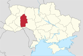
Khmelnytskyi Oblast, also known as Khmelnychchyna, is an oblast (province) in western Ukraine covering portions of the historical regions of western Podolia and southern Volhynia. The administrative center of the oblast is the city of Khmelnytskyi.

The Desna is a river in Russia and Ukraine, a major left-tributary of the Dnieper. Its name means "right hand" in the Old East Slavic language. It has a length of 1,130 km (702 mi), and its drainage basin covers 88,900 km2 (34,324 sq mi).

The Inhul is a left tributary of the Southern Bug (Boh) and is the 14th longest river of Ukraine. It flows through the Kirovohrad and Mykolaiv regions.

Right-bank Ukraine is a historical and territorial name for a part of modern Ukraine on the right (west) bank of the Dnieper River, corresponding to the modern-day oblasts of Vinnytsia, Zhytomyr, Kirovohrad, as well as the western parts of Kyiv and Cherkasy. It was separated from the left bank during the Ruin.
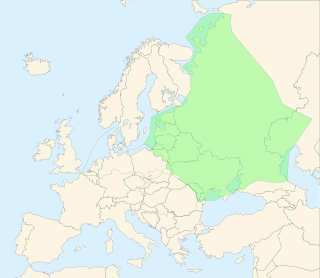
The East European Plain is a vast interior plain extending east of the North European Plain, and comprising several plateaus stretching roughly from 25 degrees longitude eastward. It includes Volhynian-Podolian Upland on its westernmost fringe, the Central Russian Upland, and, on the eastern border, encompasses the Volga Upland. The plain includes also a series of major river basins such as the Dnepr Basin, the Oka–Don Lowland, and the Volga Basin. At the southeastern point of the East European Plain are the Caucasus and Crimean mountain ranges. Together with the North European Plain, and covering the Baltic states, European Russia, Belarus, Ukraine, Moldova, southeastern Romania, and, at its southernmost point, the Danubian Plain in Northern Bulgaria, it constitutes the majority of the Great European Plain, the greatest mountain-free part of the European landscape. The plain spans approximately 4,000,000 km2 (2,000,000 sq mi) and averages about 170 m (560 ft) in elevation. The highest point of the plain, located in the Valdai Hills, is 346.9 metres (1,138.1 ft).

Zhytomyr Oblast, also referred to as Zhytomyrshchyna, is an oblast (province) in northwestern Ukraine. The administrative center of the oblast is the city of Zhytomyr. Its population is approximately 1,179,032.

The Ros is a river in Ukraine, a right tributary of the Dnieper. The Ros finds its source in the village of Ordyntsi in Pohrebyshche Raion, Vinnytsia Oblast. It is 346 kilometres (215 mi) long, and has a drainage basin of 12,600 square kilometres (4,900 sq mi). Larger settlements on the river are Bila Tserkva, Bohuslav, and Korsun-Shevchenkivskyi.

The Styr is a right tributary of the Pripyat, with a length of 494 kilometres (307 mi). Its basin area is 13,100 square kilometres (5,100 sq mi) and located in the historical region of Volhynia.

Radomyshl is a historic city in Zhytomyr Raion, Zhytomyr Oblast, northern Ukraine. Before 2020, it was the administrative center of the former Radomyshl Raion. It is located on the left bank of the Teteriv River, a right tributary of the Dnieper. Its population is approximately 13,685. It is located within the historic region of Right-bank Ukraine.

The Seym or Seim is a river that flows westward in Russia and Ukraine. It is 748 kilometres (465 mi) long and its basin area about 27,500 square kilometres (10,600 sq mi). It is the largest tributary of the Desna.

The Oster is a river in the northern Ukrainian oblast of Chernihiv. The river is a left tributary of the Desna River. It is approximately 199 km long and its basin area is 2,950 km2. It is connected by canals and streams with the Trubizh River, which flows southwest from Kyiv into the Dnieper River. Important towns and villages on the river include: Nizhyn, Kozelets, Roslavl and Oster.

The Sula is a left tributary of the Dnieper with a total length of 363 kilometres (226 mi) and a drainage basin of 19,600 square kilometres (7,600 sq mi).

The Psel or Psyol is a river, a left tributary of the Dnieper, which flows through Russia and Ukraine.

The Horyn or Haryn is a tributary of the Pripyat, which flows through Ukraine and Belarus. The Horyn is 659 kilometres (409 mi) long, and has a drainage basin of 27,700 square kilometres (10,700 sq mi). It has a maximum width of 80 m, and a maximum depth of 16 m. An important tributary of the Horyn River is the Sluch.

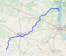
The Sluch or Southern Sluch is a river in Ukraine. It is a right tributary of the Horyn. It has a length of 451 kilometres (280 mi) and a drainage basin of 13,800 square kilometres (5,300 sq mi). The Sluch takes its source in the Ukrainian oblast of Khmelnytskyi. It then flows through the Zhytomyr and Rivne oblasts, and briefly along the Ukrainian-Belarusian border before finally emptying into the Horyn.
The Aidar is a river in Luhansk Oblast, Ukraine and Belgorod Oblast, Russia. A left tributary of the Seversky Donets, it is 264 km (164 mi) long and has a basin area of 7,420 square kilometres (2,860 sq mi). The slopes of the valley are partitioned with ravines and gorges. In the spring, snow melt accounts for approximately 70% of the flow. The average flow module is 1.7 litres • sec / km². The river freezes in December.

The Vysun, Vulsun or Isun is a river of Ukraine, flowing through the Mykolaiv Oblast. It is a right tributary of the Inhulets. It has a length of 201 km and begins in the Dnieper Upland and flows south through Prychornomorskoy Lowland, through the district center of Kazanka. It covers a basin of 2670 km2. During season it is powered mainly by snowmelt.

The Dnieper Upland or Cisdnieper Upland is a southeastern European plain occupying the territory between the Dnieper and the Southern Bug. It lies in central Ukraine, occupying the oblasts of Zhytomyr, Kyiv, Vinnytsia, Cherkasy, Kirovohrad and Dnipropetrovsk.
Brodetske is a rural settlement in Khmilnyk Raion, Vinnytsia Oblast, Ukraine. It is located on the banks of the Hnylopiat, a left tributary of the Teteriv in the drainage basin of the Dnieper. Brodetske belongs to Hlukhivtsi settlement hromada, one of the hromadas of Ukraine. Population: 2,032.