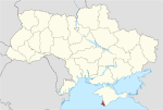
Krasnoperekopsk or Yany Kapu is a city in Crimea. Following the 2014 annexation of Crimea, it was incorporated into Russia's Republic of Crimea. However, a majority of countries recognises the territory as part of Ukraine within the Autonomous Republic of Crimea. It is the administrative center of Krasnoperekopsk Raion. Administratively is not a part of the raion (district) and is incorporated separately as a town of regional significance. Population: 26,268 .

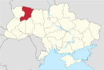
Kirovske Raion was one of the 25 regions of the Autonomous Republic of Crimea until 2020. The raion's administrative centre is the urban-type settlement of Kirovske. Population: 50,834 .

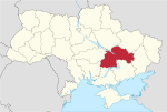
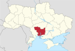
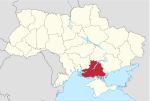
Bakhmut Raion, known as Artemivsk Raion between 1924 and 2016, is a raion (district) within the northeastern part of Donetsk Oblast in eastern Ukraine. Its administrative center is Bakhmut. Its area is 1,687 square kilometres (651 sq mi), and its population is approximately 220,275.

The Yevpatoria City Municipality is one of the 25 regions of the Autonomous Republic of Crimea, a territory recognized by almost all countries as part of Ukraine but occupied by Russia as the Republic of Crimea. The region is located on the western coast of Crimea on the Black Sea's shore. Its administrative center is the city of Yevpatoria. Population: 119,258 .

A raion, often translated as district, is the second-level administrative division in Ukraine. Raions were created in a 1922 administrative reform of the Soviet Union, to which Ukraine, as the Ukrainian Soviet Socialist Republic, belonged.
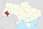
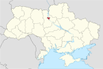
Novyi Kalyniv is a small city in Sambir Raion (district), Lviv Oblast (region) of Ukraine. Novyi Kalyniv hosts the administration of Novyi Kalyniv urban hromada, one of the hromadas of Ukraine.
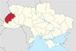
Valky is a city in Bohodukhiv Raion, Kharkiv Oblast, Ukraine. Valky is situated on the banks of the river Mzha. The city borders on such villages as Kostiv and Hontiv Yar. It hosts the administration of Valky urban hromada, one of the hromadas of Ukraine. Population: 8,577.

A hromada is a basic unit of administrative division in Ukraine, similar to a municipality. It was established by the Government of Ukraine on 12 June 2020.
An urban district or urban raion is the second-level administrative division in certain cities in Ukraine. There are 118 districts in 20 cities across Ukraine. The cities that contain districts are mostly administrative centers in addition to the two cities with special status. The number of city districts per region varies between a minimum of two and a high of 21 in Donetsk Oblast. The maximum districts for a single city in the country is Kyiv, which has 10 districts. Cities which have abolished their urban districts are marked in italics below.
Boikivske Raion or Telmanove Raion was one of the administrative raions of Donetsk Oblast, Ukraine from 1934 until 2020. The administrative center of the raion was located in the urban-type settlement of Boikivske, also known as Telmanove. The last estimate of the raion population, reported by the Ukrainian government, was 13,773.

The Autonomous Republic of Crimea is an administrative division of Ukraine encompassing most of Crimea that was unilaterally annexed by Russia in 2014. The Autonomous Republic of Crimea occupies most of the peninsula, while the City of Sevastopol occupies the rest.
Chornukhyne is a rural settlement in Alchevsk urban hromada, Alchevsk Raion (district), Luhansk Oblast (region), Ukraine. It was formerly in the Popasna Raion and then Perevalsk Raion. In the 2001 Ukrainian census, the town's population was 7,782. The current population estimate is 5,690
Soniachne is a rural settlement in the Zaporizhzhia Raion (district) of Zaporizhzhia Oblast in southern Ukraine. Its population was 588 in the 2001 Ukrainian Census. Soniachne is the administrative center of the Soniachne Rural Council, a local government area.
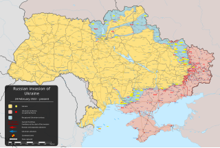
The Russian-occupied territories of Ukraine are areas of Ukraine that are currently controlled by Russia in the course of the Russo-Ukrainian War. In Ukrainian law, they are defined as the "temporarily occupied territories of Ukraine".

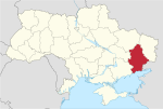
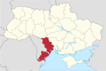
Sievierodonetsk Raion or Siverskodonetsk Raion is a raion (district) of Luhansk Oblast, Ukraine. It was created in July 2020 as part of the reform of administrative divisions of Ukraine. The center of the raion is the city of Sievierodonetsk. Population: 362,539.
Rzhyshchiv urban hromada is a hromada in Ukraine, in Obukhiv Raion of Kyiv Oblast. The administrative center is the city of Rzhyshchiv.
Lypske or Krasnyi Oktiabr is a rural settlement in Makiivka urban hromada, Donetsk Raion in Donetsk Oblast of Ukraine. Population: 886.
Anatoliy Pavlolyvch Hrytsenko is a Ukrainian politician who had last served as the 11th Governor of Kherson Oblast in 2010.