Development of the administrative divisions of Ukraine

Last updated

Administrative divisions development in Ukraine reviews the history of changes in the administrative divisions of Ukraine, in chronological order.

Contents

Russian Empire

The Russian Empire had acquired much of the territory inhabited by Ukrainians between the mid 17th and early 19th centuries, which was organized into nine Ukrainian governorates: Chernigov (Chernihiv in Ukrainian), Yekaterinoslav (Katerynoslav), Kiev (Kyiv), Kharkov (Kharkiv), Kherson, Podolia (Podillia), Poltava, Volhynia (Volyn), and the mainland part of Taurida (or Tavriia, without the Crimean peninsula). Additional lands annexed from Poland in 1815 were organized into the Kholm governorate in 1912. [1]

Ukrainian People's Republic (1917–1921)

Pohoryna zemlia Pogorina UNR.png
Pohoryna zemlia

After the creation of the Ukrainian People's Republic in 1917, the Russian governorates inhabited by Ukrainians became subdivisions of Ukraine. In 1918, there was a not fully realized territorial administrative reform in the Ukrainian People's Republic, where the country was divided into zemlias, volosts, and hromadas.

The West Ukrainian People's Republic in former Austro-Hungarian Empire territory was not subdivided into governorates, and would be annexed by the Second Polish Republic from 1919 until the Soviet invasion of 1939.

Overview of Soviet Ukraine (1919–1991)

During the existence of Soviet Ukraine its administration division went through three changes.[ citation needed ]

Before World War II

Carpatho Ukraine March 1939.png

In 1919, the northern Mhlyn, Novozybkiv, Starodub, and Surazh counties of Chernihiv Governorate, with their mixed Ukrainian–Belarusian–Russian population, were transferred from Ukraine to the newly established Gomel Governorate of the Russian republic. [2] In February 1924, Tahanrih and Shakhty counties (Tahanrizka okruha and Shakhtynska okruha) were transferred from the Donetsk Governorate of the Ukrainian SSR to the North Caucasus Krai of the Russian SFSR. [3] [4]

Czechoslovakia01.png

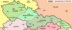
Just before World War II, Hungary with the help from Poland occupied Carpatho-Ukraine that was to secede from the falling apart Czechoslovakia after the Munich agreement plus some additional territories of Slovakia. Poland in turn also occupied some territories of Silesia.

In the fall of 1938, the southwestern territories of Subcarpathian Rus including the cities of Uzhhorod, Berehove, and Mukacheve were yielded to the Kingdom of Hungary.

In 1939, Carpatho-Ukraine was overrun by the Kingdom of Hungary.

Some of the newly acquired territories in 1939 were annexed and incorporated as Kárpátalja. Kárpátalja unlike most of the country, however, had a special administrative system with the intention of it being governed by the Ruthenian minority population. In practice, it was not the case. Kárpátalja was divided into three administrative delegations (közigazgatási kirendeltség) which were each divided into four districts (járás). The previously annexed territories of 1938 were divided into Bereg County and Ung County.

World War II

Ukraine 1940-1945.png
General Government for the occupied Polish territories (1941).png
ReichskommissariatUkraineMap.png

In 1939 and 1940, the Soviet Union launched an offensive into eastern Poland and eastern Romania. During these operations, the territories of Volhynia, Halychyna, Bukovina, and Budjak were added to the Ukrainian SSR. In the territories of Volhynia and Halychyna, six oblasts were created in 1939: Lviv Oblast, Drohobych Oblast, Stanislav Oblast, Ternopil Oblast, Volyn Oblast, and Rivne Oblast. In 1940, Bukovina was organized as Chernivtsi Oblast and Budjak as Izmail Oblast.

After the German invasion of 1941, Ukraine was split between three countries, Germany, Romania, and Hungary. Within Germany Ukraine also was divided between the General Government (Krakau), Reichskommisariat (centered in Rivne), and Wehrmacht administration closer to the Eastern Front.

General Government

Western Ukraine around Lviv was part of the General Government as Distrikt Galizien which was added to four other existing districts with the invasion of the Soviet Union. Distrikt Galizien consisted of 13 land-kreis and one stadtkreis (Lemberg). Some other territories that had been incorporated into the Ukrainian SSR in 1939 were passed to other Distrikts, mostly Krakau.

Reichskommissariat Ukraine

Most of Ukraine was under a "civil administration" of Reichskommissariat Ukraine with capital in Rowno. Some territories also included former parts of Belarus. Reichskommissariat was divided into five General-bezirke and one Teil-bezirke Taurien (Krim):

Each Generalbezirke consisted of several Kreisgebiete which in turn were divided into selsoviets. Krim, however, did not in reality encompass territory of the Crimean peninsula which was under a special jurisdiction of Wehrmacht. Territories of Ukraine (Donets basin and Sloboda Ukraine) also stayed under the Wehrmacht jurisdiction due to a close proximity to front-lines. It was planned to extend the territory of such Ukraine all the way to Volga river adding some other General-bezirke.

Romania

WWII administrative map of Romania.svg

Romania liberated the south-western part of Ukrainian Soviet Socialist Republic from the foreign rule, more specifically the area which today constitutes Odesa Oblast eastward of the Dniester and southern Vinnytsia Oblast, land inhabited mostly by Romanians a few centuries ago. Those territories were organized into the province of Transnistria. Romania also recovered Budjak (Izmail Oblast) and Northern Bukovina (Chernivtsi Oblast), territories with Romanian ethnic majority, which Romania lost in the beginning of World War II.

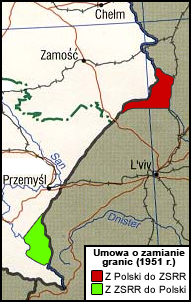
Polish-Soviet border changes (1944–1951)

Ukraine 1946-1954.png
Polish-Soviet border changes Umowa o zamianie granic 1951.jpg
Polish-Soviet border changes

Between 1944 and 1951 the border between the Ukrainian SSR and the Polish People's Republic changed a lot. There were at least five territorial transfers.

Other changes (1944–1946)

A new Kherson Oblast was created during the war on March 30, 1944, out of the territories of Mykolaiv Oblast and Zaporizhzhia Oblast. Furthermore, a few raions of Odesa Oblast (including the city of Voznesensk and its surrounding areas), were transferred to Mykolaiv Oblast.

Beside a Ukrainian-Polish border exchange on January 22, 1946, the Zakarpattia Oblast was also created out of newly acquired Czechoslovakia territories, where Carpatho-Ukraine had been proclaimed just before World War II.

1954

Big changes in the administrative division in Ukraine took place in winter of 1954.

The new Cherkasy Oblast was created on January 7, mostly out of the southern raions of Kyiv Oblast, and some raions of Poltava and Kirovohrad Oblasts.

On February 15 Izmail Oblast was merged into Odesa Oblast. Several raions of the previous Odesa Oblast were transferred to the neighboring Kirovohrad and Mykolaiv Oblasts.

The Crimean Oblast was transferred from Russia to Ukraine on February 19.

Oblast changes (1954–1991)

Before the fall of Soviet Union in 1992 the Ukrainian SSR consisted of 25 oblasts and two cities of republican subordination, Kyiv and Sevastopol.

In 1958 Voroshylovhrad Oblast was renamed Luhansk, then in 1970 back to Voroshylovhrad, and in 1990 once again to Luhansk.

May 21, 1959, Drohobych Oblast was merged into Lviv Oblast.

1965 Talalaiv Raion was transferred from Sumy Oblast to Chernihiv Oblast.

1986 Chornobyl Raion and the city municipality of Prypiat were liquidated and merged with the Ivankiv Raion, Kyiv Oblast.

In 1988 the new city of Slavutych was established for victims of the Chornobyl catastrophe, in Chernihiv Oblast. The city was subordinated to the Kyiv Oblast.

On February 12, 1991, the Crimean oblast was restored to its pre-WWII status of autonomous Soviet socialist republic following a referendum.

Modern (1991–)

After its declaration of independence in August 1991, and the dissolution of the Soviet Union in December, Ukraine grandfathered most of the Soviet system of administrative divisions.

In February 1992, the Crimean ASSR's parliament renamed it the Republic of Crimea,[ citation needed ] and in 1998 the Ukrainian parliament renamed it Autonomous Republic of Crimea, following disputes over the republic's constitution and level of autonomy. In February 2014, Russian forces occupied the peninsula including the Autonomous Republic of Crimea and city of Sevastopol, and in March formally annexed the territories to the Russian Federation, although it remained internationally recognized as part of Ukraine.[ citation needed ]

After the start of the war in Donbas in the oblasts of Donetsk and Luhansk in April 2014, Ukrainian government forces fought to hold territory against separatist militias with a significant level of Russian manpower and military support. After a period of intense warfare involving Russian regular forces in 2014 and 2015, a ceasefire was declared and a relatively stable line of contact was established, although the semi-frozen conflict has continued to cost thousands of lives along the so-called grey zone that surrounds the line of contact. About a third of the area of the two Donbas oblasts remain under the de facto control of Russian-supported self-proclaimed Donetsk and Luhansk people's republics. In these cities and raions where the respective local governments cannot exercise their constitutional powers, Ukraine created civil–military administrations in February 2015. [5]

Administrative reform of 2015

In 2015 a new type of administrative unit was created, the amalgamated hromada, to help the financial and administrate power and independence of rural Ukraine. [6] This means that settlement councils, rural councils, and cities of district significance can create new administrative units. [6] According to draft constitutional changes submitted to the Verkhovna Rada (Ukraine's parliament) by President Volodymyr Zelensky in December 2019, the hromadas should replace the raions of Ukraine. [7]

Administrative reform of 2020

Raions of Ukraine after October 2020 Raions of Ukraine (after Oct. 2020).svg
Raions of Ukraine after October 2020

On 17 July 2020, the Verkhovna Rada (Ukraine's parliament) approved an administrative reform to merge most of the 490 raions, along with the "cities of regional significance" which had been separate from raions, into just 136 reformed raions. These 136 districts include ten in Crimea and several in Donetsk and Luhansk oblasts, which were and remain under Russian control. New third-level hromadas have taken over most tasks of the raions (education, healthcare, sport facilities, culture, and social welfare). [8]

Administrative reform of 2023

On 24 October 2023 President Volodymyr Zelenskyy signed Law No. 8263 that abolished the concept of "urban-type settlement" in Ukraine. [9] Law No. 8263 was meant to facilitate "de-Sovietization of the procedure for solving certain issues of the administrative and territorial system of Ukraine." [9] (In 1991 Ukraine became independent of the Soviet Union. [10] ) The only official classifications of inhabited locality in Ukraine remained a city (misto, an urban locality), a settlement ( selyshche , a rural locality with a population of at least 5,000) and village (selo, a rural locality of less than 5,000). [9]

See also

Related Research Articles

<span class="mw-page-title-main">Oblasts of Ukraine</span> Type of first-level administrative division of Ukraine

An oblast in Ukraine, sometimes translated as region or province, is the main type of first-level administrative division of the country. Ukraine's territory is divided into 24 oblasts, as well as one autonomous republic and two cities with special status. Ukraine is a unitary state, thus the oblasts do not have much legal scope of competence other than that which is established in the Ukrainian Constitution and devolved by law. Articles 140–146 of Chapter XI of the constitution deal directly with local authorities and their competence.

<span class="mw-page-title-main">Budjak</span> Historical region in southwestern Ukraine

Budjak, also known as Budzhak, is a historical region that was part of Bessarabia from 1812 to 1940. Situated along the Black Sea, between the Danube and Dniester rivers, this multi-ethnic region covers an area of 13,188 km2 (5,092 sq mi) and is home to approximately 600,000 people. The majority of the region is now located in Ukraine's Odesa Oblast, while the remaining part is found in the southern districts of Moldova. The region is bordered to the north by the rest of Moldova, to the west and south by Romania, and to the east by the Black Sea and the rest of Ukraine.

<span class="mw-page-title-main">Mykolaiv Raion</span> Subdivision of Mykolaiv Oblast, Ukraine

Mykolaiv Raion is a raion (district) in Mykolaiv Oblast, Ukraine with a pre-war population of 636,832. Its administrative center is the city of Mykolaiv.

<span class="mw-page-title-main">Administrative divisions of the Ukrainian Soviet Socialist Republic</span>

During its existence from 1919 to 1991, the Ukrainian Soviet Socialist Republic consisted of many administrative divisions. Itself part of the highly centralized Soviet Union, sub-national divisions in the Ukrainian SSR were subordinate to higher executive authorities and derived their power from them. Throughout the Ukrainian SSR's history, other national subdivisions were established in the republic, including guberniyas and okrugs, before finally being reorganized into their present structure as oblasts. At the time of the Ukrainian SSR's independence from the Soviet Union, the country was composed of 25 oblasts (provinces) and two cities with special status, Kiev, the capital, and Sevastopol, respectively.

<span class="mw-page-title-main">Shevchenkove, Izmail Raion, Odesa Oblast</span> Rural locality in Odesa Oblast, Ukraine

Shevchenkove is a village in Izmail Raion of Odesa Oblast of Ukraine. It belongs to Kiliia urban hromada, one of the hromadas of Ukraine. It is located 63 km (39 mi) from the raion center and 28 km (17 mi) from the Dzinilor railway station. The territory has a flat topography. A large cluster of water bodies in the Danube and Northern Black Sea basins is concentrated within a radius of 30 km (19 mi). According to the 2001 census, 5,625 inhabitants lived in the village, the territory is 6.37 km2 (2.46 sq mi), with the agricultural land measuring 98.68 km2 (38.10 sq mi), and by both indicators it is the largest village in the district.

<span class="mw-page-title-main">Okruhas of the Ukrainian Soviet Socialist Republic</span> Administrative divisions of the Ukrainian SSR

An okruha is a historical administrative division of the Ukrainian Soviet Socialist Republic that existed between 1923 and 1930. The system was intended as a transitional system between the Russian Imperial division of governorates and the modern equivalent of oblasts.

<span class="mw-page-title-main">Administrative divisions of Ukraine (1918–1925)</span>

The administrative division of Ukraine in 1918 was inherited from the Russian Empire, and based on the largest unit of the gubernia with smaller subdivisions county or district, and rural district.

<span class="mw-page-title-main">Bereznehuvate Raion</span> Former subdivision of Mykolaiv Oblast, Ukraine

Bereznehuvate Raion was a subdivision of Mykolaiv Oblast of Ukraine. Its administrative center was the urban-type settlement of Bereznehuvate. The raion was abolished on 18 July 2020 as part of the administrative reform of Ukraine, which reduced the number of raions of Mykolaiv Oblast to four. The area of Bereznehuvate Raion was merged into Bashtanka Raion. The last estimate of the raion population was 19,344

<span class="mw-page-title-main">Pervomaisk Raion</span> Subdivision of Mykolaiv Oblast, Ukraine

Pervomaisk Raion is a raion (district) in Mykolaiv Oblast, Ukraine. Its administrative center is the town of Pervomaisk. Population: 145,213.

<span class="mw-page-title-main">Velyka Mykhailivka Raion</span> Former subdivision of Odesa Oblast, Ukraine

Velyka Mykhailivka Raion was a raion (district) in Odesa Oblast of Ukraine. Its administrative center was the urban-type settlement of Velyka Mykhailivka. The raion was abolished on 18 July 2020 as part of the administrative reform of Ukraine, which reduced the number of raions of Odesa Oblast to seven. The area of Velyka Mykhailivka Raion was merged into Rozdilna Raion. The last estimate of the raion population was 30,166.

<span class="mw-page-title-main">Povit</span> County territorial unit in Ukraine

A povit, also known as a county, was a type of historical territorial-administrative and judicial unit in Ukraine, administered by a starosta. Under the Russian Empire, the Russian administration introduced the system of uezds which locally were still referred in old manner as povits. After Ukraine declared its independence in 1918, povits remained in use until the introduction of raions in 1923.

<span class="mw-page-title-main">Arbuzynka</span> Rural locality in Mykolaiv Oblast, Ukraine

Arbuzynka is a rural settlement in Pervomaisk Raion in the north of Mykolaiv Oblast, Ukraine. It hosts the administration of Arbuzynka settlement hromada, one of the hromadas of Ukraine. Population: 5,954.

Kostiantynivka is a rural settlement in Voznesensk Raion in the north of Mykolaiv Oblast, Ukraine. It belongs to Yuzhnoukrainsk urban hromada, one of the hromadas of Ukraine. Population: 2,154.

<span class="mw-page-title-main">Berezanka</span> Rural locality in Mykolaiv Oblast, Ukraine

Berezanka is a Rural settlement in Mykolaiv Raion in the south of Mykolaiv Oblast, Ukraine. It hosts the administration of Berezanka settlement hromada, one of the hromadas of Ukraine. Population: 4,000.

<span class="mw-page-title-main">Kazanka, Ukraine</span> Rural locality in Mykolaiv Oblast, Ukraine

Kazanka is a rural settlement in Bashtanka Raion in the northeast of Mykolaiv Oblast, Ukraine. It host the administration of Kazanka settlement hromada, one of the hromadas of Ukraine. Population: 6,523.

<span class="mw-page-title-main">Kryve Ozero</span> Rural locality in Mykolaiv Oblast, Ukraine

Kryve Ozero is a Rural settlement in Pervomaisk Raion in the northwest of Mykolaiv Oblast, Ukraine. It hosts the administration of Kryve Ozero settlement hromada, one of the hromadas of Ukraine. Population: 7,262.

<span class="mw-page-title-main">Oleksandrivka, Oleksandrivka settlement hromada, Voznesensk Raion, Mykolaiv Oblast</span> Rural locality in Mykolaiv Oblast, Ukraine

Oleksandrivka is a rural settlement in Voznesensk Raion, Mykolaiv Oblast, Ukraine. It hosts the administration of Oleksandrivka settlement hromada, one of the hromadas of Ukraine. Population: 5,040.

Yelanets is a rural settlement in Voznesensk Raion. Mykolaiv Oblast, Ukraine. It hosts the administration of Yelanets settlement hromada, one of the hromadas of Ukraine. Population: 4,636.

<span class="mw-page-title-main">Ivanivka, Odesa Oblast</span> Rural locality in Odesa Oblast, Ukraine

Ivanivka is a rural settlement in Berezivka Raion, in the west of Odesa Oblast, Ukraine. It hosts the administration of Ivanivka settlement hromada, one of the hromadas of Ukraine. Population: 2,362.

<span class="mw-page-title-main">Odesa Oblast</span> Oblast (region) of Ukraine

Odesa Oblast, also referred to as Odeshchyna (Одещина), is an oblast (province) of southwestern Ukraine, located along the northern coast of the Black Sea. Its administrative centre is the city of Odesa. Population: 2,351,382.

References

  1. Kohut, Zenon E.; Nebesio, Bohdan Y.; Yurkevich, Myroslav (2005). "Administrative Divisions of Ukraine". Historical dictionary of Ukraine. Bohdan Y. Nebesio, Myroslav Yurkevich. Lanham, Md.: Scarecrow Press. ISBN   0-8108-5387-6. OCLC   57002343.
  2. "Chernihiv gubernia". Encyclopedia of Ukraine. Retrieved 2020-05-28.
  3. Struk, Danylo Husar (1993-12-15). Encyclopedia of Ukraine: Volume IV: Ph-Sr. University of Toronto Press. ISBN   9781442651265.
  4. Krinko, Evgeny F. (2015). "'…To Elect a Parity Commission': Documents about the Transfer of Taganrog and Shakhty Districts to the RSFSR in 1924–1925" (PDF). Russkii Arhkiv. 10 (4): 288–295. doi: 10.13187/ra.2015.10.288 .
  5. "Poroshenko gave the green light to create civil-military administrations". Ukrainska Pravda . Ukrainian. 26 February 2015. Retrieved 26 February 2015.
  6. 1 2 (in Ukrainian) Elections in the united territorial communities. What is this and what you need, Espreso TV (31 October 2017)
  7. "Zelensky's decentralization: without features of Donbass, but with districts and prefects". BBC Ukrainian (in Ukrainian). 16 December 2019.
  8. Where did 354 districts disappear to? Anatomy of loud reform, Glavcom (7 August 2020) (in Ukrainian)
  9. 1 2 3 "Zelensky canceled urban-type settlements" (in Ukrainian). Ukrainska Pravda. 25 October 2023. Retrieved 24 October 2023.
  10. A History of Ukraine: The Land and Its Peoples Archived 7 April 2023 at the Wayback Machine by Paul Robert Magocsi, University of Toronto Press, 2010, ISBN   1442610212 (page 563/564 & 722/723)