The following is the mountains in South Korea by height.
| Mountain | Height | Region | Image | Notes |
|---|---|---|---|---|
| Mount Halla | 1,950 m (6,400 ft) | Jeju |  | The highest mountain in South Korea. |
| Mount Jiri | 1,915 m (6,283 ft) | Gyeongnam (Jeonnam/Jeonbuk) |  | The highest mountain in South Korean mainland. |
| Banya Peak | 1,732 m (5,682 ft) | Jeonnam/Jeonbuk (Gyeongnam) | Belongs to the Mount Jiri National Park. The highest mountain in Jeonnam and Jeonbuk. | |
| Mount Seorak | 1,708 m (5,604 ft) | Gangwon |  | The highest mountain in Gangwon. |
| Mount Deogyu | 1,614 m (5,295 ft) | Jeonbuk (Gyeongnam) | 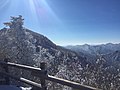 | |
| Mount Gyebang | 1,577 m (5,174 ft) | Gangwon | ||
| Mount Hambaek | 1,573 m (5,161 ft) | Gangwon | Belongs to the Mount Taebaek National Park. | |
| Mount Taebaek | 1,567 m (5,141 ft) | Gangwon (Gyeongbuk) |  | |
| Mount Odae | 1,563 m (5,128 ft) | Gangwon | ||
| Mount Gariwang | 1,561 m (5,121 ft) | Gangwon | ||
| Gari Peak | 1,519 m (4,984 ft) | Gangwon | Belongs to the Mount Seorak National Park. | |
| Mount Namdeogyu | 1,507 m (4,944 ft) | Gyeongnam (Jeonbuk) | Belongs to the Mount Deogyu National Park. | |
| Duwi Peak | 1,470 m (4,820 ft) | Gangwon | ||
| Mount Hwaak | 1,468 m (4,816 ft) | Gyeonggi (Gangwon) | The highest mountain in Gyeonggi. | |
| Mount Barwang | 1,459 m (4,787 ft) | Gangwon | ||
| Mount Bangtae | 1,444 m (4,738 ft) | Gangwon | ||
| Mount Sobaek | 1,440 m (4,720 ft) | Gyeongbuk/Chungbuk | The highest mountain in Chungbuk. | |
| Mount Gaya | 1,433 m (4,701 ft) | Gyeongnam/Gyeongbuk | 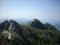 | |
| Manbokdae | 1,433 m (4,701 ft) | Jeonnam/Jeonbuk | Belongs to the Mount Jiri National Park. | |
| Mount Baegun | 1,426 m (4,678 ft) | Gangwon |  | |
| Mount Jeombong | 1,424 m (4,672 ft) | Gangwon | Belongs to the Mount Seorak National Park. | |
| Mount Sangwon | 1,421 m (4,662 ft) | Gangwon | ||
| Jangsan | 1,409 m (4,623 ft) | Gangwon | ||
| Mount Hwangbyeong | 1,407 m (4,616 ft) | Gangwon |  | Belongs to the Mount Odae National Park. |
| Mount Cheongok | 1,404 m (4,606 ft) | Gangwon |  | |
| Mount Duta | 1,391 m (4,564 ft) | Gangwon | Also called Mount Bakji. | |
| Mount Baekseok | 1,365 m (4,478 ft) | Gangwon | ||
| Mount Eungbok | 1,360 m (4,460 ft) | Gangwon | ||
| Mount Geumwon | 1,353 m (4,439 ft) | Gyeongnam | ||
| Mount Baekdeok | 1,349 m (4,426 ft) | Gangwon | ||
| Mount Gaein | 1,342 m (4,403 ft) | Gangwon | ||
| Hoeryeong Peak | 1,331 m (4,367 ft) [1] | Gangwon | ||
| Danji Peak | 1,324 m (4,344 ft) | Gyeongnam/Gyeongbuk | ||
| Mount Nochu | 1,322 m (4,337 ft) | Gangwon | ||
| Mount Sudo | 1,317 m (4,321 ft) | Gyeongnam/Gyeongbuk | ||
| Dosol Peak | 1,314 m (4,311 ft) | Gyeongbuk/Chungbuk | Belongs to the Mount Sobaek National Park. |