
The highest mountains in Iran include Damavand, Alam-Kuh, Sabalan, Takht-e Soleyman, Azad Kuh, Zard-Kuh, and Shir Kuh.
This is a list of mountains in the country of Iran.


By clicking on the symbols at the head of the table the individual columns may be sorted.
| Ranking | Photograph | Mountain | Height (m) | Range |
|---|---|---|---|---|
| 1 | 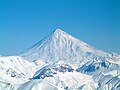 | Mount Damavand | 5,610 [1] | Middle Alborz Mountains |
| 2 |  | Alam-Kuh | 4,850 | Takht-e Suleyman Mountains |
| 3 |  | Sabalan | 4,811 | |
| 4 | North Khersan | 4,680 | Takht-e Suleyman Mountains | |
| 5 | South Khersan | 4,659 | Takht-e Suleyman Mountains | |
| 6 |  | Mount Takht-e Suleyman | 4,659 | Takht-e Suleyman Mountains |
| 7 | Siahsang | 4,604 | Takht-e Suleyman Mountains | |
| 8 | Haft Khan | 4,537 | Takht-e Suleyman Mountains | |
| 9 | Chaloon | 4,516 | Takht-e Suleyman Mountains | |
| 10 | South Siahgook | 4,500 | Takht-e Suleyman Mountains | |
| 11 |  | Hazaran | 4,501 | Central Iranian plateau |
| 12 |  | Siah-Kaman | 4,472 | Takht-e Suleyman Mountains |
| 13 | Shaneh-Kuh | 4,465 | Takht-e Suleyman Mountains | |
| 14 | North Siahgook | 4,445 | Takht-e Suleyman Mountains | |
| 15 | Kaloo | 4,412 | Takht-e Suleyman Mountains | |
| 16 |  | Dena | 4,409 | Zagros Mountains |
| 17 | Gardoon Kuh | 4,402 | Takht-e Suleyman Mountains | |
| 18 | Kuh-e Shah (Lalehzar) | 4,384 | Zagros Mountains | |
| 19 | Kholeno | 4,375 | Middle Alborz Mountains | |
| 20 |  | Azad Kuh | 4,375 | Middle Alborz Mountains |
| 21 | Paloon Gardan | 4,375 | Middle Alborz Mountains | |
| 22 | Nazer | 4,350 | Middle Alborz Mountains | |
| 23 |  | Mian-Seh-Chal | 4,348 | Takht-e Suleyman Mountains |
| 24 | Lashgarak | 4,256 | Takht-e Suleyman Mountains | |
| 25 |  | Sialan | 4,250 | West Alborz Mountains |
| 26 |  | Mount Chlchama | 4,250 | North Zagros Mountains |
| 27 | Palvar | 4,229 | Zagros Mountains | |
| 28 |  | Zard-Kuh | 4,221 | Zagros Mountains |
| 29 | Koloon Bastak | 4,200 | Middle Alborz Mountains | |
| 30 |  | Shah Alborz | 4,200 | West Alborz Mountains |
| 31 | Zarin Kuh | 4,200 | Takht-e Suleyman Mountains | |
| 32 | Khashechal | 4,180 | West Alborz Mountains | |
| 33 | Jupar | 4,150 | Zagros Mountains | |
| 34 | Sarakchal | 4,150 | Middle Alborz Mountains | |
| 35 | Naz | 4,108 | West Alborz Mountains | |
| 36 | Varevasht | 4,100 | Middle Alborz Mountains | |
| 37 | Kharsang | 4,100 | Middle Alborz Mountains | |
| 38 | Shir Kuh | 4,050 | Zagros Mountains | |
| 39 | Kahar (Mountain) | 4,050 | West Alborz Mountains | |
| 40 | Alanehsar | 4,050 | Takht-e Suleyman Mountains | |
| 41 |  | Oshtorankuh | 4,050 | Zagros Mountains |
| 42 | Shahankuh | 4,040 | Zagros Mountains | |
| 43 | Korma Kuh | 4,020 | Takht-e Suleyman Mountains | |
| 44 | Pasand Kuh | 4,000 | Takht-e Suleyman Mountains | |
| 45 | Siahleiz | 3,975 | Takht-e Suleyman Mountains | |
| 46 | Bel Mountain | 3,943 | Zagros Mountains | |
| 47 |  | Taftan | 3,941 | Baluchestan Mountains |
| 48 |  | Tochal | 3,933 | Middle Alborz Mountains |
| 49 | Mehrchal | 3,920 | Middle Alborz Mountains | |
| 50 | Dalankuh | 3,915 | Zagros Mountains | |
| 51 | Shahvar | 3,890 | East Alborz Mountains | |
| 52 | Mount Bahr Aseman | 3,886 | Sahand-Bazman range | |
| 53 | 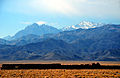 | Karkas | 3,870 | Karkas Mountains |
| 54 | Atash Kuh | 3,850 | Middle Alborz Mountains | |
| 55 | Shah Neshin (Mountain) | 3,850 | Middle Alborz Mountains | |
| 56 |  | Sahand | 3,707 | Azerbaijan Mountains |
| 57 | Sataple | 3,669 | Zagros Mountains | |
| 58 | Garrin | 3,623 | Zagros Mountains | |
| 59 | West Alborz Mountains | 3,609 | ||
| 60 |  | Alvand Kuh | 3,580 | Zagros Mountains |
| 61 | Bazman | 3,490 | Baluchestan Mountains | |
| 62 | 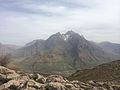 | Paraw | 3,415 | central Zagros Mountains |
| 63 |  | Shaho | 3,390 | central Zagros Mountains |
| 64 | Tsikhe | 3,350 | Zagros Mountains | |
| 65 | Qezel Arsalan | 3,250 | Zagros Mountains | |
| 66 | Jahanbin | 3,220 | Zagros Mountains | |
| 67 |  | Binalud | 3,220 | Middle Alborz Mountains |
| 68 | Birk Mountain | 2,740 | Baluchistan Mountains | |
| 69 | Baghdasht Peak | 2,500 | ||
| 70 | Sharbak | 1,694 | Middle Alborz Mountains | |