The Caucasus Mountains is a mountain range at the intersection of Asia and Europe. Stretching between the Black Sea and the Caspian Sea, they are surrounded by the Caucasus region and are home to Mount Elbrus, the highest peak in Europe at 5,642 metres (18,510 ft) above sea level.

The Iranian plateau or Persian plateau is a geological feature spanning parts of the Caucasus, Central Asia, South Asia, and West Asia. It makes up part of the Eurasian plate, and is wedged between the Arabian plate and the Indian plate. The plateau is situated between the Zagros Mountains to the west, the Caspian Sea and the Köpet Dag to the north, the Armenian Highlands and the Caucasus Mountains to the northwest, the Strait of Hormuz and the Persian Gulf to the south, and the Indian subcontinent to the southeast.

Kabir Kuh is one of the long ranges of the Zagros Mountains near the border of Lurestan and Ilam provinces in Ilam province, Iran. Covering an area of 9,500 km2 (3,700 sq mi), Kabir Kuh stretches 175 km (109 mi) in length and 48–80 km (30–50 mi) in width along the Zagros Mountains in the northwest–southeast direction. It begins about 20 km (12 mi) south of Ilam and stretches down to the vicinity of Andimeshk in Khuzestan. Made mainly by Cretaceous sedimentary rocks, the Kabir Kuh range consists of a large number of mountains, including Shah Ahmad, Tabriz, Kaleh-bad, Filman, Damaghey-e Anar, Rivasan, Puneh, Sabzkhani, Zarrin, Golgol that are covered by snow and ice all year round. Its highest peak is Kan Seifi with 2,790 m (9,150 ft) elevation, 50 km (31 mi) south-east of Ilam. Kabir Kuh runs along the Seymareh River, which becomes Karkheh when joins the Kashkan river before reaching the border of Ilam province and Khuzestan province. Kabir Kuh divides the mountainous region in western Iran into two regions generally referred as Piškuh and Poštkuh, the latter virtually coinciding with Ilam. In prehistoric times, one of the largest known landslides occurred on the north-eastern slope of Kabir Kouh, moving across the Seymareh River.

The Zagros Mountains are a long mountain range in Iran, northern Iraq, and southeastern Turkey. The mountain range has a total length of 1,600 km. The Zagros range begins in northwestern Iran and roughly follows Iran's western border while covering much of southeastern Turkey and northeastern Iraq. From this border region, the range continues southeast to the waters of the Persian Gulf. It spans the southern parts of the Armenian highlands, and the whole length of the western and southwestern Iranian plateau, ending at the Strait of Hormuz. The highest point is Mount Dena, at 4,409 metres (14,465 ft).

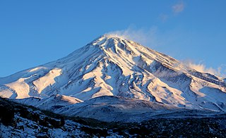
Mount Damavand is a dormant stratovolcano and is the highest peak in Iran and Western Asia, the highest volcano in Asia, and the 3rd highest volcano in the Eastern Hemisphere, at an elevation of 5,609 metres (18,402 ft). Damāvand has a special place in Persian mythology and folklore. It is in the middle of the Alborz range, adjacent to Varārū, Sesang, Gol-e Zard, and Mīānrūd. It is near the southern coast of the Caspian Sea, in Amol City, Mazandaran State, 66 km (41 mi) northeast of the city of Tehran.

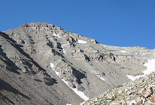
Castle Peak is the ninth highest summit of the Rocky Mountains of North America and the U.S. state of Colorado. The prominent 14,272-foot (4350.20 m) fourteener is the highest summit of the Elk Mountains and the Maroon Bells-Snowmass Wilderness. The peak is located 11.6 miles (18.7 km) northeast by north of the Town of Crested Butte, Colorado, United States, on the drainage divide separating Gunnison National Forest and Gunnison County from White River National Forest and Pitkin County. The summit of Castle Peak is the highest point of both counties.

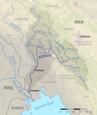
The Karun is the Iranian river with the highest water flow, and the country's only navigable river. It is 950 km (590 mi) long. The Karun rises in the Zard Kuh mountains of the Bakhtiari district in the Zagros Range, receiving many tributaries, such as the Dez and the Kuhrang. It passes through the city of Ahvaz, the capital of the Khuzestan Province of Iran, before emptying to its mouth into Arvand Rud.

Alvand is a subrange of the Zagros Mountains in western Iran located 10 km south of the city of Hamadan in Hamadan province. Its summit has an elevation of 3,580 m (11,750 ft). The main body of the Alvand range extends for about 50 km from east to west, while their maximum north–south width is about 30 km. Formed as part of the Zagros orogeny in the late Jurassic and early Cretaceous, the mountains rise sharply from the surrounding plains and are scored by many deep valleys. The mountains are mostly granite and diorite, which are types of intrusive rock.

Dena is the name for a sub-range within the Zagros Mountains, Iran. Mount Dena, with 80 km length and 15 km (49,000 ft) average width, is situated on the boundary of the Isfahan, Kohgiluyeh and Boyer-Ahmad and Chaharmahal and Bakhtiari Provinces of Iran.

Shir Kuh or Shirkuh is a high peak in central Iran about 40 km (25 mi) south-west of the city of Yazd in Yazd province.

Alam-Kūh or Mount Alam is a mountain in Alborz mountain range in northern Iran, Mazandaran Province, forming a peak of Takht-e Suleyman Massif. It is located in Kelardasht District of Mazandaran Province. With an elevation of 4,828 meters, it is the second-highest peak in Iran after Mount Damavand.
Garrin Mountain, or Kuh-e Garin, is a vast high-elevated mountain of the Zagros Mountains, located in the provinces of Hamedan and Lorestan in western Iran.
Hazaran, is a massif of the Central Iranian Plateau, and an eastern outlier of the Zagros Mountains. Hazaran is located in Kerman Province, in southeast Iran. With an elevation of 4,500 metres, it is the highest peak in Kerman Province. The jebal Barez chain is a continuation to the south-east. The Halil River rises in the Bid Khan region. The massif is situated in the area encircled by the cities of Kerman, Bardsir, Sirjan, Baft, Jiroft and Bam.

Buckner Mountain is a tall peak in the North Cascades of Washington state and in the Stephen Mather Wilderness of North Cascades National Park. At 9,114 feet (2,778 m) in elevation it is the highest in Skagit County and one of about ten of Washington's non-volcanic peaks above 9,000 feet high. It is ranked as the 14th highest peak in the state, and the third highest peak in North Cascades National Park.
Kuh-e Haji Ebrahim is a mountain of the Qandil Mountains, a subrange of the Zagros Mountains. The peak is located in western Iran and eastern Iraq, in western Asia.

Bazoft District is in Kuhrang County, Chaharmahal and Bakhtiari province, Iran. Its capital is the city of Bazoft.
Shahankuh is a mountain located about 20 kilometres southwest of the city of Fereydunshahr in the western part of Isfahan province in Iran. With an elevation of 4,040 metres, the Shahankuh is the highest mountain in Isfahan Province. Situated in the Zagros Mountains and stretched in a general northwest–southeast direction and almost parallel to other Zagros mountains, the Shahankuh has an average width of about 3 kilometres and a length of almost 20 kilometres.


