List of beaches in Albania

Last updated
Map of Albania's coastline with its beaches (2018) Harta e Bregdetit Shqiptar (2018).svg
Map of Albania's coastline with its beaches (2018)

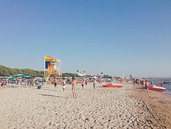
This is a list of beaches in Albania, listed geographically by coastline. [1]

Contents

Adriatic coast

Velipoje Plazhi i Velipojes, ne zonen e derdhjes se Bunes.jpg
Velipojë
Rodoni Cape Kepi Rodonit .jpg
Rodoni Cape
Golem Golem Beach.jpg
Golem

Albania's Adriatic coastline lies mainly on the eastern side of the Adriatic Sea, emerging from the Buna estuary, where the designated boundary line with Montenegro is drawn and stretching all the way down toward the Karaburun Peninsula, where Gjuhëza Cape is its westernmost point. [2]

Numerous rivers flowing into the Adriatic Sea form bays, lagoons and inlets. The sand and silt they bring are deposited in areas of reduced flow, which form the sides of the bays, with narrow swales. The depositional coastline is characterized by a low elevation on a slightly uneven relief, with the presence of sandy beaches and lagoons aligned primarily in a North-South orientation. [3] Some areas of the coast are highlighted by sand dunes covered in Mediterranean vegetation. The coastal section of the Western Lowlands is continually expanding through land reclamation, while other areas of the coast experience erosive deterioration, as is the case in Patok, the Seman estuary and Lalzi bay. The Bay of Vlorë features high and rocky cliffs, particularly around the Karaburun Peninsula. [4]

The total length of the coastline is approximately 274 km (170 mi), of which 178 km (111 mi) consist primarily of white sandy beaches and the rest of various landforms of the sea coast. The most popular beaches by number of visitors include Durrës, Golem, Lalzi Bay, Shëngjin, Velipojë, Divjakë, Spille, etc. [5]

Ionian coast

Ksamil Ksamil tourism.jpg
Ksamil
Bunec Bunec beach Albanian Riviera.jpg
Bunec
Jal Jala Beach Vlora Albania.jpg
Jal

The Ionian coast extends from Gjuhëza Cape to the Bay of Ftelie in a Northwest-Southeast orientation. The coastline is characterized by rugged, eroded tectonic formations with towering cliffs, numerous capes, and a combination of small horseshoe-shaped bays and sandy beaches. Some notable bays along the coast include Ftelie, Butrint, Saranda, Kakome, Borsh, Porto Palermo, Spile, Jal and Bristan (Arushë). The main peninsulas are Ksamil, Qefali and Karaburun.

The coastline stands out for its high abrasive intensity, primarily due to the deep sea and the absence of river discharges. Waves can surge to heights exceeding 4 meters, colliding against the rocky shores.

Ohrid lake

Beach in Pogradec Beach in Pogradec.jpg
Beach in Pogradec

Pogradec Beach lies on the shores of Lake Ohrid, in the eastern municipality of Pogradec. It was formed due to the lake's surface reduction caused by tectonic subsidence, leading to the discovery of sandy deposits brought by the stream flowing through Pogradec and other streams entering the lake.

At a length of 8 km (5.0 mi), the beach extends from the city pier to the eastern end of Tushemisht and is divided into two sections: 1) the City beach, which stretches along the "1 Maji" promenade and features fine to medium sand; 2) Tushemisht and Drilon beaches, known for their more abrasive sand, which form part of the Drilon-Tushemisht Waterscape Park, covered in lush vegetation and characterized by springs that gracefully flow into the lake.

See also

Related Research Articles

<span class="mw-page-title-main">Geography of Albania</span>

Albania is a country in Southeastern Europe that lies along the Adriatic and Ionian Seas, with a coastline spanning approximately 476 km (296 mi). Situated on the Balkan Peninsula, it is one of the most mountainous countries in Europe. It is bounded by Montenegro to the northwest, Kosovo to the northeast, North Macedonia to the east and Greece to the southeast and south.

<span class="mw-page-title-main">Tourism in Albania</span> Overview of tourism in Albania

Tourism in Albania has been a key element to the country's economic activity and is constantly developing. Albania is characterized by its rich archaeological and cultural heritage dating back to the classical period when Illyrians and Ancient Greeks inhabited the region. Over the course of history, the territory of Albania was occupied and populated by Romans, Byzantines, Venetians and Ottomans. Notably the country features unspoiled beaches, mountainous landscapes, traditional cuisine, archaeological artifacts, unique traditions, low prices and the wild atmosphere of the countryside.

<span class="mw-page-title-main">Sazan</span> Island in Albania

Sazan is an Albanian uninhabited island in the Mediterranean Sea. The largest of Albania's islands, it is a designated military exclusion zone; it lies in a strategically important location between the Strait of Otranto and the mouth of the Bay of Vlorë, marking the border between the Adriatic and Ionian seas.

<span class="mw-page-title-main">Durrës County</span> County in central Albania

Durrës County, officially the County of Durrës, is a county in the Northern Region of the Republic of Albania. It is the smallest by area and the second most populous of the twelve counties, with 292,029 people within an area of 766 km2 (296 sq mi). The county borders on the Adriatic Sea to the west, the counties of Lezhë to the north, Dibër to the east and Tirana to the south. It is divided into three municipalities, Durrës, Krujë and Shijak, with all of whom incorporate sixteen administrative units.

<span class="mw-page-title-main">Vlorë County</span> County of Albania

Vlorë County is one of the 12 counties of the Republic of Albania with the capital in Vlorë. The county spans 2,706 square kilometres (1,045 sq mi) and has a total population of 187,675 people as of 2021. It borders the counties of Fier and Gjirokastër, as well as the Adriatic and Ionian Sea.

<span class="mw-page-title-main">Shëngjin</span> Municipal unit in Lezhë, Albania

Shëngjin is a coastal town and a former municipality in Lezhë County, northwestern Albania. At the 2015 local government reform it became a subdivision of the municipality of Lezhë. The population at the 2011 census was 8,091. Shëngjin is a growing tourist destination, well known for its beaches and resort accommodations. Shëngjin is one of many cities within the District of Lezhë and is home to one of Albania's entry ports, Port of Shëngjin.

<span class="mw-page-title-main">Albanian Naval Force</span> Military unit

The Albanian Naval Force is the naval branch of the Albanian military. Their name was changed from the Albanian Naval Defense Forces in 2010. The Naval Force is headquartered in Durrës, and operates multiple bases, including Kepi i Palit base in Durrës, and Pashaliman in Vlorë.

<span class="mw-page-title-main">Velipojë</span> Village and former municipality in Shkodër, Albania

Velipojë is a village and a former municipality in Shkodër County, northwestern Albania. At the 2015 local government reform, it became a subdivision of the municipality of Shkodër. The population at the 2011 census was 5,031.

<span class="mw-page-title-main">Albanian Riviera</span> Tourist attraction in Albania

The Albanian Riviera, also popularly known as Bregu, is a coastline along the north-eastern Ionian Sea in the Mediterranean Sea, encompassing the districts of Sarandë and Vlorë in south-western Albania. It forms an important section of the Albanian Ionian Sea Coast, dotted with the villages of Palasë, Dhërmi, Vuno, Himara, Qeparo, Borsh, Piqeras, Lukovë, and the city of Sarandë.

<span class="mw-page-title-main">Gulf of Drin</span> Inlet of the Adriatic Sea in the northern coast of Albania

The Gulf of Drin or Bay of Drin is an ocean basin of the Adriatic Sea within the Mediterranean Sea along the northern coast of Albania. Roughly scythe-shaped, it extends immediately from the Delta of the Buna in the north, across the port city of Shëngjin, to the Cape of Rodon in the south. The shoreline of the gulf is a shallow combination of sandy beaches, sand dunes, capes, salty and fresh water wetlands, estuaries, pine and coastal forests, reed beds and coastal meadows.

<span class="mw-page-title-main">Albanian dialects</span> Overview of dialects of Albanian

The Albanian language is composed of many dialects, divided into two major groups: Gheg and Tosk. The Shkumbin river is roughly the geographical dividing line, with Gheg spoken north of the Shkumbin and Tosk south of it.

Border crossings in the Republic of Albania are defined as boundary checkpoints that serve to control the flow of people and goods from neighbouring countries to and from Albania. These checkpoints are administered by the border police authorities that record the entry and exit of each person and vehicle followed by the customs authorities that record the entry and exit of goods and cash. Albania currently has 22 operational land border crossings and shares borders with Montenegro, Kosovo, North Macedonia, and Greece. This article outlines a complete list of Albania's international border crossings, including land, sea and air entry points.

<span class="mw-page-title-main">Bay of Vlorë</span> Bay in Albania bordering the Adriatic Sea

The Bay of Vlorë is a large bay of the Adriatic Sea situated along the Albanian Adriatic Sea Coast on the Mediterranean Sea in Southern Europe. It opens to the sea in the northwest and is largely surrounded by the lagoon of Narta in the north, the city of Vlorë in the northeast, the mountains of the Ceraunians in the east and southeast, and the peninsula of Karaburun in the southwest and west.

<span class="mw-page-title-main">Himarë (town)</span> Place

Himarë is a town in Southern Albania along the Albanian Riviera and part of the Vlorë County. It is the largest settlement and the seat of the municipality of Himarë. The town is populated predominantly by an ethnic Greek community.

<span class="mw-page-title-main">Karaburun Peninsula, Albania</span> Peninsula on the southwest coast of Albania

The Karaburun Peninsula is a peninsula of the Mediterranean Sea located in Southern and Southeastern Europe, which is almost completely surrounded by both the Adriatic Sea to the north and the Ionian Sea to the south. It is located in Southwestern Albania along the Albanian Ionian Sea Coast, whereas the Strait of Otranto separates it from Italy. The Strait of Mezokanal separates the peninsula from Sazan Island, while in the southeast stretches the Bay of Vlorë. Its name “Karaburun” derives from Turkish for "black cape". In classical antiquity, its name was the "Akrokeraunian Peninsula", whose name was derived from the eponymous Akrokeraunian mountains;this is because, in terms of geology, the Rrëza e Kanalit on the peninsula represent the continuation of said mountains, which are the highest and most extensive mountain range system that extends parallel to the Ionian Sea. Karaburun peninsula is sometimes called Ceraunian Peninsula due to the name of the mountain range. Created during the mesozoic era of the cretaceous and paleogene period, the crests of the mountain range form a northwest-southeast line with a series of distinct peaks along its irregular structure that are broken apart by steep and unequally slopes. The highest peaks are namely, the Maja Çaderës, Maja e Flamurit, Maja e Koretës and Maja e Ilqes.

The regions of Albania—apart from the official present and historical administrative divisions—include the following:

<span class="mw-page-title-main">Highways in Albania</span> Transport network in Albania

The Highways in Albania are the central state and main transport network in Albania. The motorways and expressways are both part of the national road network. The motorways are primary roads with a speed limit of 110 kilometres per hour (68 mph). They have white on green road signs such as in Italy and other countries nearby. The expressways are the secondary roads, also dual carriageways, but without an emergency lane. They have a speed limit of 90 kilometres per hour (56 mph). They have white on blue road signs.

<span class="mw-page-title-main">Albanian Adriatic Sea Coast</span> Albanian coastline of the south-eastern Adriatic Sea

The Albanian Adriatic Sea Coast stretches in the south-eastern Adriatic Sea beginning at the Gulf of Drin in the north, across the port cities of Shëngjin, Durrës, and Vlorë, to the Bay of Vlorë in the south, where the Albanian Riviera as well as the Albanian Ionian Sea Coast begins.

<span class="mw-page-title-main">Albanian Ionian Sea Coast</span> Albanian coastline of the north-eastern Ionian Sea

The Albanian Ionian Sea Coast is a coastline of the north-eastern Ionian Sea, that encompasses the south-western border of the Republic of Albania, stretching from the southern half of Karaburun Peninsula, across the historical region of Labëria, the city of Sarandë, the mountains of the Ceraunians, and the Albanian Riviera, to the Lake of Butrint, where the Strait of Corfu separates the country from Greece.

<span class="mw-page-title-main">Buna River-Velipojë Protected Landscape</span> Protected area and a tourist attraction in Albania

The Buna River-Velipojë Protected Landscape is a protected landscape area in northwestern Albania, encompassing the estuary of Drin, the lagoon of Viluni, the river of Buna with its estuary, and the gulf of Drin that runs across the city of Velipojë alongside the Adriatic Sea.

References

  1. "United Nations Environment Programme Mediterranean Action Plan" (PDF). UNEP: 11. 13 September 2019.
  2. Buda, Aleks (1985). Fjalori Enciklopedik Shqiptar. Tiranë: Akademia e Shkencave e RPSSH. pp. 184–185.
  3. Kabo, Mevlan (1990). Gjeografia Fizike e Shqipërisë (1st ed.). Tiranë: Qendra e Studimeve Gjeografike. pp. 154–160.
  4. Pano, Niko (2015). Pasuritë ujore të Shqipërisë. Akademia e Shkencave e Shqipërisë. pp. 476–548. ISBN   978-99956-10-87-6.
  5. "Plani i integruar ndërsektorial për brezin bregdetar". AKPT. Retrieved 12 April 2023.