
Vlorë is the third most populous city of Albania and seat of Vlorë County and Vlorë Municipality. Located in southwestern Albania, Vlorë sprawls on the Bay of Vlorë and is surrounded by the foothills of the Ceraunian Mountains along the Albanian Adriatic and Ionian Sea Coasts. It experiences a Mediterranean climate, which is affected by the Ceraunian Mountains and the proximity to the Mediterranean Sea.

Vlorë District was one of the 36 districts of Albania, which were dissolved in July 2000 and replaced by 12 newly created counties. It had a population of 147,267 in 2001, and an area of 1,609 km2 (621 sq mi). It is in the south-west of the country, and its capital was the city of Vlorë. Its territory is now part of Vlorë County: the municipalities of Vlorë, Selenicë and Himara (partly). Its population included a Greek minority.
Markat is a village and a former municipality in Vlorë County, southern Albania. In the 2015 local government reform, it became a subdivision of the municipality Konispol. The population in the 2011 census was 1,859. The municipal unit consists of the villages Dishat, Vërvë, Shalës, Markat, Ninat and Janjar and all villages are inhabited by Muslim Cham Albanians.
Dhivër is a village and a former municipality in the Vlorë County, southern Albania. At the 2015 local government reform it became a subdivision of the municipality Finiq. The population at the 2011 census was 1,396,

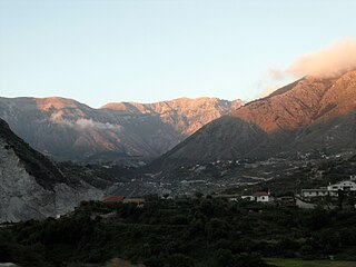
Horë-Vranisht is a village and a former municipality in the Vlorë County, southwestern Albania. At the 2015 local government reform it became a subdivision of the municipality Himarë. The population at the 2011 census was 2,080. The municipal unit consists of the villages Vranisht, Kuç, Bolenë, Kallarat and Tërbaç.
Kotë is a village and a former municipality in the Vlorë County, southwestern Albania. At the 2015 local government reform it became a subdivision of the municipality Selenicë. The population at the 2011 census was 3,516. The municipal unit consists of the villages Kotë, Gumeicë, Hysoverdhë, Lapardha, Mavrovë, Mazhar, Vajzë, Vodicë, Shkallë Mavrovë and Drashovicë.
Sevaster is a village and a former municipality in the Vlorë County, southwestern Albania. At the 2015 local government reform it became a subdivision of the municipality Selenicë. The population at the 2011 census was 1,720. The municipal unit consists of the villages Sevaster, Golimbas, Dushkarak, Shkozë, Mazhar, Ploçë, Lezhan and Amonicë.
Armen is a village and a former municipality in the Vlorë County, southwestern Albania. At the 2015 local government reform it became a subdivision of the municipality Selenicë. The population at the 2011 census was 2,965. The municipal unit consists of the villages Armen, Karbunarë, Rromës, Treblovë, Lubonjë, Picar and Mesarak.

Shushicë is a village and a former municipality in the Vlorë County, southwestern Albania. At the 2015 local government reform it became a subdivision of the municipality Vlorë. The population at the 2011 census was 3,981. The municipal unit consists of the villages Shushicë, Bunavi, Beshisht, Grabian, Drithas, Mekat, Llakatund, Çeprat and Risili.

Novoselë is a village and a former municipality in the Vlorë County, southwestern Albania. At the 2015 local government reform it became a subdivision of the municipality Vlorë. The population at the 2011 census was 8,209.The village formerly had a railway station, which closed in 1997. The etymology of the village comes from Slavic languages meaning new village, Novo Selo. In Albanian it turned into Novoselë.
Qendër Vlorë is a former municipality in the Vlorë County, southwestern Albania. At the 2015 local government reform it became a subdivision of the municipality Vlorë. The population at the 2011 census was 7,621. The municipal unit consists of the villages Bestrovë, Babicë e Madhe, Babicë e Vogël, Hoshtimë, Kaninë, Kërkovë, Nartë, Sherishtë, Panaja, Xhyherinë, Zvërnec and Sazan Island. Nartë and Zvërnec are predominantly Greek-speaking settlements.

Llogara National Park is a national park centered on the Ceraunian Mountains along the Albanian Riviera in southwestern Albania, spanning a surface area of 1,769 ha (17.69 km2). The park's terrain includes large alpine meadows, vertical rock faces, precipices and dense forests. Most area of the park is covered by forests and was established in 1966 to protect several ecosystems and biodiversity of national importance. The International Union for Conservation of Nature (IUCN) has listed the park as Category II. The region has been recognised as an important Bird and Plant Area, supporting significant number of species.
Dukat is a community in Vlorë County, southern Albania. With the 2015 local government reform, it became part of the municipality Vlorë. The Dukat Plain covers an area of around 1,000–1,500 ha delimited by the Ceraunian Mountains and opened in the north towards the Bay of Vlorë on the Adriatic. Dukat traditionally belongs to the Albanian ethnographic region of Labëria.
Tërbaç is a community in the Vlorë County, southwestern Albania. At the 2015 local government reform it became part of the municipality Himarë.

Dervish Ali's Towers are an early 19th century complex of towers in Dukat, Vlorë County, Albania. It is a Cultural Monument of Albania since 1979

The Karaburun Peninsula, also known as Cape Linguetta, is a peninsula of the Mediterranean Sea located in Southern and Southeastern Europe, which is almost completely surrounded by both the Adriatic Sea to the north and the Ionian Sea to the south. It is located in Southwestern Albania along the Albanian Ionian Sea Coast, whereas the Strait of Otranto separates it from Italy. The Strait of Mezokanal separates the peninsula from Sazan Island, while in the southeast stretches the Bay of Vlorë. In classical antiquity, its name was the "Akrokeraunian Peninsula", whose name was derived from the eponymous Akrokeraunian mountains; this is because, in terms of geology, the Rrëza e Kanalit on the peninsula represent the continuation of said mountains, which are the highest and most extensive mountain range system that extends parallel to the Ionian Sea. Karaburun peninsula is sometimes called Ceraunian Peninsula due to the name of the mountain range. Formed during the mesozoic era of the cretaceous and paleogene period, the crests of the mountain range form a northwest-southeast line with a series of distinct peaks along its irregular structure that are broken apart by steep and unequally slopes. The highest peaks are namely, the Maja Çaderës, Maja e Flamurit, Maja e Koretës and Maja e Ilqes.

The Port of Shëngjin or Shëngjin Harbor is a port of Albania in the city of Shëngjin, Albania.

Karaburun-Sazan Marine Park is a marine park in the Vlorë County of southwestern Albania. The marine park encompasses over 125.70 km2 (48.53 sq mi) and comprises the boundaries of both the Peninsula of Karaburun and the Island of Sazan. It is home to a vast array of landforms, including mountains, caves, islands, depressions, bays, cliffs, canyons and rocky coasts, all contributing to an exceptionally considerable biological diversity. The marine park has been identified as an Important Bird and Plant Area, because it supports immense bird and plant species. Containing ecosystems and habitats that are specific to the Mediterranean Basin, the convention of Barcelona has classified the marine park as a Specially Protected Areas of Mediterranean Importance.

The Llogara Pass ; is a high mountain pass within the Ceraunian Mountains along the Albanian Riviera. It connects the Dukat Valley in the north with Himarë in the south. Orikum is the nearest city on the northern side of the pass and the village of Dhërmi in the south.

The Cave of Haxhi Ali is a karst cave formed in limestone cliffs in southwestern Albania, located in the Karaburun Peninsula near the Cape of Gjuhëz in Vlorë County. The cave was named after Haxhi Aliu, a prominent Albanian warrior and sailor from Ulcinj who fled with his son in this cave. Several archaeological objects has been found, that prove that this cave was used by traders and passers during the ancient times. The cave has a length of 30 m (98 ft) with a width which can vary between of 10–12 m (33–39 ft) and a height of 18 m (59 ft).


