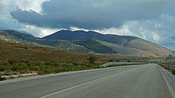
Konispol

Last updated
Konispol
Konispol.jpg
Stema e Bashkise Konispol.svg
Albania (location map).svg
Red pog.svg
Konispol
Coordinates: 39°40′N20°11′E / 39.667°N 20.183°E / 39.667; 20.183
CountryFlag of Albania.svg  Albania
County Vlorë
Government
   Mayor Ergest Duli (PS)
Area
  Municipality226.26 km2 (87.36 sq mi)
Elevation
389 m (1,276 ft)
Population
 (2011)
  Municipality
8,245
  Municipality density36/km2 (94/sq mi)
  Municipal unit
2,123
Time zone UTC+1 (CET)
  Summer (DST) UTC+2 (CEST)
Postal Code
9705
Area Code(0)891
Website www.bashkiakonispol.gov.al

Konispol (definite form : Konispoli) is the southernmost town in Albania. It sits one kilometer away from the Albanian-Greek border. The settlement is inhabited by Muslim Cham Albanians. [1] Konispol is the modern centre of the Cham Albanian community in Albania. The main economic interests of Konispol are agriculture and viticulture.

Contents

The town is the seat of the southernmost administrative unit in Albania, the Municipality of Konispol (Albanian : Bashkia Konispol). It was formed during the 2015 local government reform by the merger of the former municipalities of Konispol, Markat and Xarrë. [2] The total population is 8,245 (2011 census), [3] in a total area of 226.26 km2. [4] The population of the former Konispol municipality at the 2011 census was 2,123. [3]

The former Konispol municipal unit (pre-2015) consisted of the town Konispol and the village Çiflik. [5] The new larger municipality of Konispol contains settlements that are inhabited by Albanians who form the majority of the population, Aromanians, Greeks and Romani that live in the villages of Xarrë municipal unit. [1] [6] [7]

Name

The name of the settlement Konispol is derived from kon'c (коньць) and polya (поля), Slavic words for end and field referring to the end of a field. [8]

History

The most ancient traces of human presence in Konispol can be found in the Kreçmoi Cave on the late period of the Middle Paleolithic era (40,000-30,000 years ago). [9] [10] [11]

The area was part of the ancient region of Epirus and was inhabited by Chaonian Epirotes. [12]

In 1943, Konispol is noted for being the battleground of a fierce conflict between German units, Cham collaborators from the Thesprotia province in Greece of the Nuri Dino battalion, and the communist Albanian resistance. [13] On 8 October 8 1943, a meeting of the Albanian and Greek communist resistance groups took place in the town. [14] Apart from recognising that Albanian and Greek minorities existed on either side of the border, due to disagreements between the communist movements, a separate headquarters for the communist resistance units of the Greek minority in Albania was planned. [14]

In 1992, 7 caves were discovered just north of the town with findings that dated from the Upper Paleolithic age to the Iron Age. [15]

Modern period

Konispol, due to its proximity to the Albanian-Greek borders, is part of the European Union's Greece – Albania Neighbourhood Programme for improving the standard of living of the local population by promoting sustainable local development in the cross-border area between the two countries.

Municipality demographics

The municipal seat Konispol, [6] along with the villages of Dishat, Vërvë, Shalës, Markat, Ninat and Janjar are populated by native Muslim Cham Albanians. [1] The village of Xarrë is inhabited by an Orthodox Albanian majority, Muslim Albanian Chams (200) that arrived from northern Greece in the 1920s and 1940s, a combined population of Aromanians and Greeks (50) and some Romani. [1] [6] Mursi is inhabited by an Orthodox Albanian majority, alongside a few Muslim Albanians and Greeks. [1] [6] [16] Çiflik is inhabited by Orthodox Albanians, Aromanians, Muslim Albanians and a few Greeks. [1] Shkallë is inhabited by an Aromanian majority, alongside a few Muslim Albanians and Greeks and also contains a few families of Muslim Romani originally from Filiates, Greece who were expelled in 1944–1945. [1] [7] Vrinë is a new village established during the communist period and is populated by Muslim Albanians (400), Orthodox Albanians (318) and Greeks (300). [1]

Location

Konispol is:

Notable people

Related Research Articles

Cham Albanians or Chams, are a sub-group of Albanians who originally resided in the western part of the region of Epirus in southwestern Albania and northwestern Greece, an area known among Albanians as Chameria. The Chams have their own particular cultural identity within Albanian sub-groups. A number of Chams contributed to the Albanian national identity and played an important role in starting the renaissance of the Albanian culture in the 19th century. The Chams speak their own dialect of the Albanian language, the Cham Albanian dialect, which is a Southern Tosk Albanian dialect and one of the two most conservative ones; the other being Arvanitika.

<span class="mw-page-title-main">Sarandë District</span> Defunct (2000) Albanian administrative area

Sarandë District was one of the 36 districts of Albania, which were dissolved in July 2000 and replaced by 12 newly created counties. It had a population of 35,235 in 2001, and an area of 730 km2 (280 sq mi). The centre of the district was the city of Sarandë. Other places included Konispol, Ksamil, Çukë, Vrinë and Butrint. Its territory is now part of Vlorë County: the municipalities of Sarandë, Konispol, Finiq (partly) and Himara (partly).

<span class="mw-page-title-main">Gjirokastër District</span> Defunct (2000) Albanian administrative area

Gjirokastër District was one of the 36 districts of Albania, which were dissolved in July 2000 and replaced by 12 counties. It had a population of 55,991 in 2001, and an area of 1,137 km2 (439 sq mi). It contained a large Greek ethnic minority. It is in the south of the country, and its capital was the city of Gjirokastër. Its territory is now part of Gjirokastër County: the municipalities of Gjirokastër, Dropull and Libohovë.

Markat is a village and a former municipality in Vlorë County, southern Albania. In the 2015 local government reform, it became a subdivision of the municipality Konispol. The population in the 2011 census was 1,859. The municipal unit consists of the villages Dishat, Vërvë, Shalës, Markat, Ninat and Janjar and all villages are inhabited by Muslim Cham Albanians.

<span class="mw-page-title-main">Chameria</span> Designation of a historical region located in Epirus which was mostly inhabited by Cham Albanians.

Chameria is a term used today mostly by Albanians to refer to parts of the coastal region of Epirus in southern Albania and Greece, traditionally associated with the Albanian ethnic subgroup of the Chams. For a brief period (1909-1912), three kazas were combined by the Ottomans into an administrative district called Çamlak sancak. Apart from geographic and ethnographic usages, in contemporary times within Albania the toponym has also acquired irredentist connotations. During the interwar period, the toponym was in common use and the official name of the area above the Acheron river in all Greek state documents. Today it is obsolete in Greek, surviving in some old folk songs. Most of what is called Chameria is divided between parts of the Greek regional units of Thesprotia, Preveza, and Ioannina ; and the municipality of Konispol at the southernmost extremity of Albania. As the wider Greek toponyms Epirus has existed since antiquity and the narrower Thesprotia also reflects an ancient name, and given the negative sentiments towards Albanian irredentism, the term is not used by the locals on the Greek side of the border.

<span class="mw-page-title-main">Ksamil</span> Municipal unit in Vlorë, Albania

Ksamil is a village and a former municipality in the riviera of Southern Albania, and part of Butrint National Park. At the 2015 local government reform it became a subdivision of the municipality Sarandë. The population at the 2011 census was 2,994; while according to the Civil Offices it was 9,220. The municipal unit consists of the villages Ksamil and Manastir. During the communist era, the coastal village of Ksamil was built in 1966 and is located south of the city of Sarandë off the road to Butrint.

<span class="mw-page-title-main">Filiates</span> Place in Greece

Filiates is a town and a municipality in Thesprotia, Greece. It is located in the northernmost part of the regional unit, bordering western Ioannina regional unit and southern Albania.

Zagoria is a former municipality in the Gjirokastër County, southern Albania. During the 2015 local government reform, Zagoria became a subdivision of the municipality Libohovë. The population at the 2011 census was 411. Since 2018, the region has been at the centre of the expanded Zagoria Nature Park. Zagoria is also considered to be a distinct "ethnographic region", traditionally consisting of 10 settlements: Sheper, Nivan, Ndëran, Topovë, Konckë, Hoshteve, Lliar, Vithuq, Doshnicë and Zhej.

<span class="mw-page-title-main">Vergo</span> Municipal unit in Vlorë, Albania

Vergo is a village and a former municipality in the Vlorë County, southern Albania. At the 2015 local government reform it became a subdivision of the municipality Delvinë. The population at the 2011 census was 1,844. The municipal unit consists of the villages Vergo, Tatzat, Kalasë, Fushë Vërri, Kopaçez, Qafë Dardhë and Bajkaj inhabited by Muslim Albanians and Senicë populated by an Orthodox Albanian population, making up 94% and 6% of the total each.

<span class="mw-page-title-main">Lukovë</span> Municipal unit in Vlorë, Albania

Lukovë is a village and a former municipality in the Vlorë County, southern Albania. At the 2015 local government reform, it became a subdivision of the municipality Himarë. The population at the 2011 census was 2,916.

Xarrë is a village and a former municipality in the Vlorë County, southern Albania. At the 2015 local government reform it became a subdivision of the municipality Konispol. The population at the 2011 census was 4,263. The municipal unit consists of the villages Xarrë, Mursi, Shkallë and Vrinë.

Livadhe is a village and a former commune in Vlorë County, southern Albania. At the 2015 local government reform it became a subdivision of the municipality Finiq. The population at the 2011 census was 1,165. The municipal unit consists of the villages Livadhja; Kulluricë; Llazat; Kalcat; Kodër; Lefter Talo; Vagalat; Gravë; Qesarat; Komat; Karroq; Grazhdan; and Zminec, while Sopik is inhabited by an Orthodox Albanian population and Pandalejmon by Muslim Cham Albanians. A study by Leonidas Kallivretakis in 1993 found that the population of the commune consisted of 85% ethnic Greek Christians, 10% Albanian Christians, and 5% Albanian Muslims.

<span class="mw-page-title-main">Cham Albanian dialect</span> Dialect of the Albanian language

The Cham Albanian dialect, also called Cham Tosk or Arvanitika, is the dialect of the Albanian language spoken by the Cham Albanians, an ethnic Albanian minority in the Epirus region of northwestern Greece and in Konispol, southern Albania.

Vrinë is a village in the former Xarrë municipality, Vlorë County in Albania. At the 2015 local government reform it became part of the municipality Konispol.

<span class="mw-page-title-main">Party for Justice and Integration</span> Political party in Albania

Party for Justice and Integration, was a political party in Albania that represented the Cham Albanians in politics. In February 2011, it dissolved into the Party for Justice, Integration and Unity.

Selckë is a small village in the former Pogon municipality in the Gjirokastër County, southern Albania. At the 2015 local government reform it became part of the municipality Dropull. In the early 1990s, the village was inhabited by an Orthodox Albanian majority and an Aromanian minority, while in the 2010s a Greek community is also recorded.

Saraqinisht is a small village of the former Antigonë municipality in the Gjirokastër County, southern Albania. At the 2015 local government reform it became part of the municipality Gjirokastër. Near the village are the remains of the ancient city of Antigonea, which was founded by Pyrrhus of Epirus, and named after his wife, Antigone. Saraqinisht is inhabited by an Orthodox Albanian population and an Aromanian minority.

<span class="mw-page-title-main">Qestorat</span> Village in Gjirokastër, Albania

Qestorat is a community of the former Lunxhëri municipality in the Gjirokastër County, southern Albania. At the 2015 local government reform it became part of the municipality Gjirokastër.

<span class="mw-page-title-main">Sheper</span> Village in Gjirokastër, Albania

Sheper is a community in the Gjirokastër County, southern Albania. Sheperi is the largest village of the former Zagori municipality. At the 2015 local government reform it became part of the municipality Libohovë. It is mountain village located 30 km from the city of Gjirokastër, about 800 meters above sea level. Due to heavy migration, its current population is about 100 inhabitants. Sheper is inhabited by an Orthodox Albanian population.

<span class="mw-page-title-main">Piqeras</span> Village in Vlorë, Albania

Piqeras is a village in the former municipality of Lukovë, Vlorë County, southern Albania. At the 2015 local government reform it became part of the municipality Himarë.

References

  1. 1 2 3 4 5 6 7 8 Kallivretakis, Leonidas (1995). "Η ελληνική κοινότητα της Αλβανίας υπό το πρίσμα της ιστορικής γεωγραφίας και δημογραφίας [The Greek Community of Albania in terms of historical geography and demography." In Nikolakopoulos, Ilias, Kouloubis Theodoros A. & Thanos M. Veremis (eds). Ο Ελληνισμός της Αλβανίας [The Greeks of Albania]. University of Athens. p. 51. "Ε Έλληνες, ΑΧ Αλβανοί Ορθόδοξοι Χριστιανοί, AM Αλβανοί Μουσουλμάνοι, ΤΣ Τσάμηδες, Β Βλάχοι, Μ Μικτός πληθυσμός”; p.52. “KONISPOL ΚΟΝΙΣΠΟΛΗ 2380 ΤΣ; VERVE BEPBA 345 ΤΣ; DISHAT ΝΤΙΣΑΤΙ 317 ΤΣ; SHALES ΣΑλΕΣΙ 1168 ΤΣ; ΝΙΝΑΤ NINATI (ΝΙΝΑΤΕΣ) 547 ΤΣ; MARKAT MAPKATI 748 ΤΣ; JANJAR ΓΙΑΝΑΡΙ 595 ΤΣ; XARRE TZAPA 2085 AX + αμ (200) + ε/β (50); MURSI ΜΟΥΡΣΙ (ΜΟΥΡΤΣΙΑ) 1984 AX + αμ + ε; VRINE BPINA (νέο) 1018 M (400 AM+ 318 ΑΧ+ 300 E); SHKALLE ΣΚΑΛΛΑ 619 Β + αμ + ε; ÇIFLIK ΤΣΙΦΛΙΚΙ 525 Μ (ΑΧ + Β + AM + ε)"
  2. "Law nr. 115/2014" (PDF) (in Albanian). p. 6376. Retrieved 25 February 2022.
  3. 1 2 "Population and housing census - Vlorë 2011" (PDF). INSTAT . Retrieved 2019-09-25.
  4. "Correspondence table LAU – NUTS 2016, EU-28 and EFTA / available Candidate Countries" (XLS). Eurostat . Retrieved 2019-09-25.
  5. Greece – Albania Neighbourhood Programme Archived March 27, 2012, at the Wayback Machine
  6. 1 2 3 4 Kretsi, Georgia (2005). "The uses of origin: Migration, Power-struggle and Memory in southern Albania". In King, Russell; Mai, Nicola; Schwandner-Sievers, Stephanie (eds.). The New Albanian Migration. Brighton-Portland: Sussex Academic. ISBN   9781903900789. pp. 197-198. The first village, Xarrë, contains a mixed population in regard to confession and language.[3] The village is about 15 km from the Albanian-Greek border crossing point (for pedestrians) of Qafë Bota and around 30 km from the district capital, Sarandë. The second community, Mursi, consists of a rather homogeneous population in terms of religious affiliation and language (Christian and Albanian speaking) and is located just 1 km away from Xarrë. The third village, Konispol, around 10 km distant from these villages, is a traditionally Muslim, Albanian speaking settlement and is situated close to the 'green line' with Greece."; p. 210. "[3]. In Xarrë the relevant groups were Albanian-speaking Christians, Çam people (or Chams - the Albanian speaking minority settled in northern Greece/Epirus in the 1920s and 1940s), Vlachs (cattle breeders, speaking a Latin-based language), Roma, and some members of the Greek minority."
  7. 1 2 Baltsiotis, Lambros (2015). "Balkan Roma immigrants in Greece: An initial approach to the traits of a migration flow", International Journal of Language, Translation and Intercultural Communication. 1. (1): 5. " In general terms, it seems that previous ties of any kind with Greece facilitate not only the migration but also a more permanent way of living in the country. This is the case with the Muslim Roma of Filiati in Thesprotia who, following the expulsion of the Muslim Albanian Chams from Greece in 1944-1945, were settled in the village of Shkallë, Sarandë in Albania. The majority of the families, more than fifteen, gradually settled in Greece.
  8. Ylli, Xhelal (2000). Das slavische Lehngut im Albanischen. 2 [Slavic settlement in Albania . Verlag Otto Sagner. p. 127. "KONISPÓL,-I 1431 Konisboli, Vayonetya; 1856 Κονίσπολις) A. VA 37 Κονίσπολις. B. Im türk. Register als Dorf bezeichnet. VA bezieht sich mit Vorbehalt auf die Erklärung von Hilferding 287: zu *коньць поля ,Feldende‘. In diesem Fall hätte man es mit einer alten Form zu tun, die den Reflex ь> I widerspiegelt, vgl. Dibrri usw. C. EI SO 2 96 Kuhschnappel Koniecpol (pol.), Konecpol’ (russ.), HE HSK Końčnopole. [KONISPÓL,-I 1431 Konisboli, Vayonetya; 1856 Κονίσπολις) A. VA 37 Κονίσπολις. B. In Turk. In the Register called as a village. VA refers conditionally to the statement of Hilferding 287: to *коньць поля, Field's End'. In this case you would have to do with an old form that ь the reflex reflecting> I see. Dibrri etc. C. EI SO 2 96 Kuhschnappel Koniecpol (pol.), Konecpol’ (russ.), HE HSK Końčnopole.]"
  9. Sheme, Selman (2016). Çamëria-Vështrim gjeopopullativ dhe etnokulturor (in Albanian). Tiranë: Albas. p. 21. ISBN   978-9928-02-778-8.
  10. Myzyri, Hysni (2001). Historia e Shqipërisë dhe Shqiptarëve (in Albanian). Prizren: Sprint. pp. 13–14. OCLC   60603000.
  11. Korkuti, Muzafer; Petruso, Karl M.; Bejko, Lorenc; EIlwood, Brooks B.; Hansen, Julie M.; Harrold, Francis B.; Rusell, Nerissa; Bottema, Sytze (1996). "Shpella e Konispolit (Raport paraprak për gërmimet e viteve 1992-1994) / Konispol cave, Albania (A preliminary report on excavation, 1992-1994)". Iliria. 26 (1): 183–224. doi:10.3406/iliri.1996.1666.
  12. Hammond, N.G.L. (1997). "Hammond The Tribal Systems of Epirus and Neighbouring Areas down to 400 B.C.". Epirus, 4000 Years of Greek History and Civilization: 55. Chaonian power thus ran from the northern end of the Gulf of Aulon (adjacent to Apollonia) to the southern end of the plain by Konispolis
  13. Meyer, Hermann Frank (2008). Blutiges Edelweiß: Die 1. Gebirgs-division im zweiten Weltkrieg [Bloodstained Edelweiss. The 1st Mountain-Division in WWII] (in German). Ch. Links Verlag. ISBN   978-3-86153-447-1.
  14. 1 2 Kretsi, Georgia (2002). "The 'Secret' Past of the Greek-Albanian Borderlands". Ethnologia Balkanica (6): 181. In 1943 the first rapprochements had taken place between the Albanian and Greek communist resistance movements, and although no concrete statuses were defined, the minorities on both sides were recognized mutually for the first time.[35].; [35]Serious disagreements emerged, however, due to the convention of Konispol (8/10/1943) a separate headquarters for the Greek minority was planned
  15. Schuldenrein, Joseph (1998-06-01). "Konispol Cave, southern Albania, and correlations with other Aegean caves occupied in the Late Quaternary". Geoarchaeology. 13 (5): 501–526. doi:10.1002/(sici)1520-6548(199806)13:5<501::aid-gea3>3.0.co;2-4. ISSN   1520-6548.
  16. Hammond, Nicholas Geoffrey Lemprière (1967). Epirus: the Geography, the Ancient Remains, the History and Topography of Epirus and Adjacent Areas. Oxford: Clarendon Press. p. 95. ISBN   9780198142539. "The small hamlet of Çiflik lies below the hill of Aetos, and it is one hour's walk from there to Murzië, an Albanian speaking village of 700 people"
  17. Elsie, Robert (1992). "Albanian Literature in the Moslem Tradition: Eighteenth and Early Nineteenth Century Albanian Writing in Arabic Script". Oriens. 33: 287–306. doi:10.2307/1580608. JSTOR   1580608.