
Paiania is a town and a municipality in East Attica, Greece. It is an eastern suburb of Athens, located east of Mount Hymettus. It is 11 km east of Athens city centre.

Falaisia is a village and a former municipality in southwestern Arcadia, Peloponnese, Greece. Since the 2011 local government reform it is part of the municipality Megalopoli, of which it is a municipal unit. The municipal unit has an area of 274.926 km2. The seat of the municipality was in Leontari, 5 km northwest of the village Falaisia. The municipal unit Falaisia is located in the northern foothills of the Taygetus mountains, south of Megalopoli and north of Kalamata. It borders on Laconia to the southeast, and Messenia to the southwest.

Igoumenitsa is a coastal city in northwestern Greece. It is the capital of the regional unit of Thesprotia.

Malakasa is a village and former community of East Attica in Greece. Since the 2011 local government reform it is part of the municipality Oropos, of which it is a municipal unit. The municipal unit has an area of 10.450 km2. The municipal unit Malakasa consists of the villages Malakasa, Milesi and Sfendali.

Thespies is a village in Boeotia, Greece. A former municipality, which included the village, shared the same name. Since the 2011 local government reform it is part of the municipality Aliartos-Thespies, of which it is a municipal unit. Population 3,386 (2021). The municipal unit has an area of 108.152 km2, the community 12.725 km2.
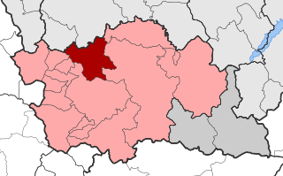
Agios Kosmas is a village, a community and a municipal unit of the Grevena municipality. Before the 2011 local government reform it was an independent municipality. The municipality was established in 1997 with the name Kosmas o Aitolos, which was changed to Agios Kosmas in 2004. The seat of the municipality was in Megaro. The 2021 census recorded 54 residents in the community and 681 residents in the municipal unit. The community of Agios Kosmas covers an area of 9.496 km2 while the municipal unit covers an area of 115.087 km2. The village is named after the 18th-century saint Cosmas the Aetolian.

Sagiada is a village and a former municipality in Thesprotia, Epirus, Greece. Since the 2011 local government reform it is part of the municipality Filiates, of which it is a municipal unit. The municipal unit has an area of 87.803 km2. In 2021 its population was 515 for the village and 1,580 for the municipal unit. The seat of the municipality was in Asprokklisi.

Perdika is a village and a former community in Thesprotia, Epirus, Greece. Since the 2011 local government reform it is part of the municipality Igoumenitsa, of which it is a municipal unit. The municipal unit has an area of 34.605 km2.

Vertiskos, known before 1927 as Berovo (Μπέροβο), is a village a community and a former municipality in the Thessaloniki regional unit, Greece. Since the 2011 local government reform it is part of the municipality Lagkadas, of which it is a municipal unit. The 2021 census recorded 279 people in the community and 1,644 people in the municipal unit of Vertiskos. The community of Vertiskos covers an area of 46.629 km2 while the respective municipal unit covers an area of 196.613 km2.

Ano Pogoni is a former municipality in the Ioannina regional unit, Epirus, Greece. Since the 2011 local government reform it is part of the municipality Pogoni, of which it is a municipal unit. The municipal unit has an area of 137.084 km2. The seat of the municipality was in Kefalovryso.

Kalpaki is a former municipality in the Ioannina regional unit, Epirus, Greece. Since the 2011 local government reform it is part of the municipality Pogoni, of which it is a municipal unit. It is situated about 30 km (19 mi) northwest of Ioannina, and southwest of Konitsa. The municipal unit has an area of 116.756 km2, the community 13.189 km2. The Greek National Road 20 connects Kalpaki with Ioannina and Konitsa. The GR-22 connects Kalpaki with Kakavia, the border crossing into southern Albania.

Gramos is a remote mountain village and a former municipality in Kastoria regional unit, Macedonia, Greece. Since the 2011 local government reform it is part of the Nestorio municipality as a municipal unit. The municipal unit has an area of 59.422 km2. Population 10 (2021). The village is a traditional Aromanian (Vlach) settlement, named after the nearby Gramos mountains to its south. It lies very close to the Albanian border. The source of the river Aliakmonas is near Gramos. It had the smallest population of any municipality in Greece at 28 inhabitants in the 2001 Greek census. It was also the least densely populated community or municipality in Greece, at 0.47 inhabitants/km2. A small road connects Gramos with Nestorio, 20 km to its east. Gramos is the nearest village to Lake Gkistova.

Pentalofos, is a village and a former community in Kozani regional unit, Western Macedonia, Greece. Since the 2011 local government reform it is part of the municipality Voio, of which it is a municipal unit. It is located at 1060 meters elevation to the base of mountain Voio. The municipal unit has an area of 83.923 km2, the community 38.113 km2. The population of the municipal unit was 367 people, while the population of the community itself was 272 people as of 2021.

Sminos is a former municipality in Laconia, Peloponnese, Greece. Since the 2011 local government reform it has been part of the municipality East Mani, of which it is a municipal unit. The municipal unit has an area of 94.503 km2. Population 1,139 (2021).
Makrychori is a former municipality in the Larissa regional unit, Thessaly, Greece. Since the 2011 local government reform it has been part of the municipality Tempi, of which it is a municipal unit. The municipal unit has an area of 107.767 km2. The municipality was created under the Kapodistrias Law in 1997 out of the former communes of Elateia, Evangelismos, Gyrtoni and Parapotamos.

Malakasi is a village and a former municipality in the Trikala regional unit, Thessaly, Greece. Since the 2011 local government reform it is part of the municipality Meteora, of which it is a municipal unit. The municipal unit has an area of 157.534 km2. Population 612 (2021). The seat of the municipality was in Panagia.

Salamina or Kοullοuri is the largest city and a former municipality on Salamina Island in Greece. Since the 2011 local government reform it is part of the municipality of Salamina, of which it is the seat and a municipal unit.
Kalloni is a village and a community of the Grevena municipality. Before the 2011 local government reform it was a part of the municipality of Agios Kosmas, of which it was a municipal district. The 2021 census recorded 13 residents in the village. The community of Kalloni covers an area of 9.447 km2.
Knidi is a village and a community of the Grevena municipality. Before the 2011 local government reform it was a part of the municipality of Ventzio, of which it was a municipal district and the seat. The 2021 census recorded 411 residents in the community. The community of Knidi covers an area of 81.901 km2.
Syndendro is a village and a community of the Grevena municipality. Before the 2011 local government reform it was a part of the municipality of Grevena, of which it was a municipal district. The 2021 census recorded 155 residents in the village. The community of Syndendro covers an area of 19.229 km2.

