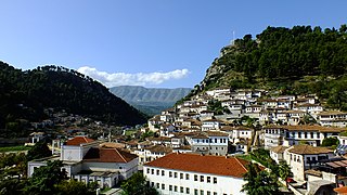
Berat is the ninth most populous city of Albania and the seat of Berat County and Berat Municipality. By air, it is 71 kilometres north of Gjirokastër, 70 kilometres west of Korçë, 70 kilometres south of Tirana, and 33 kilometres east of Fier. Berat is located in the south of the country. It is surrounded by mountains and hills, including Tomorr on the east that was declared a national park. The river Osum runs through the city before it empties into the Seman within the Myzeqe Plain. The municipality of Berat was formed at the 2015 local government reform by the merger of the former municipalities Berat, Otllak, Roshnik, Sinjë, and Velabisht, that became municipal units. The seat of the municipality is the city Berat. The total population is 62,232 as of the 2023 census, in a total area of 421.6 km2 (162.8 sq mi).

Tourism in Albania has been a key element to the country's economic activity and is constantly developing. Albania is characterized by its rich archaeological and cultural heritage dating back to the classical period when Illyrians and Ancient Greeks inhabited the region. Over the course of history, the territory of Albania was occupied and populated by Romans, Byzantines, Venetians and Ottomans. Notably the country features unspoiled beaches, mountainous landscapes, traditional cuisine, archaeological artifacts, unique traditions, low prices and the wild atmosphere of the countryside.

Burrel is a town in northern Albania, 91 km from Tirana. At the 2015 local government reform it became a subdivision and the seat of the municipality Mat. It was the seat of the former District of Mat. The population as of the 2023 census is 7,928.

Skrapar District was one of the 36 districts of Albania, which were dissolved in July 2000 and replaced by 12 newly created counties. It had a population of 29,874 in 2001, and an area of 775 km2 (299 sq mi). It was in the centre of the country, and its capital was the town of Çorovodë. Its territory is now part of Berat County: the municipalities of Skrapar and Poliçan (partly).

Fier is the seventh most populous city of the Republic of Albania and seat of Fier County and Fier Municipality. It is situated on the bank of Gjanica River in the Myzeqe Plain between the Seman in the north, the Vjosë in the south and the foothills of the Mallakastra Mountains in the southeast. Fier experiences a seasonal Mediterranean climate affected by its proximity to the Adriatic Sea in the west.

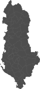
Berat County, officially the County of Berat, is a county in the Southern Region of the Republic of Albania. It is the ninth largest by area and the ninth most populous of the twelve counties, with around 140,956 people within an area of 1,798 km2 (694 sq mi). The county borders the counties of Elbasan to the north, Korçë to the east, Gjirokastër to the south and Fier to the west. It is divided into five municipalities, Berat, Dimal, Kuçovë, Poliçan and Skrapar, with all of whom incorporate twenty-five administrative units.

Vlorë County is one of the 12 counties of Albania with the city of Vlorë being the county capital. The county spans 2,706 square kilometres (1,045 sq mi) and has a total population of 146,681 people as of 2023. It borders the counties of Fier and Gjirokastër, as well as the Adriatic and Ionian Sea. Greece borders Vlorë to the south.

The Osum is a river in southern Albania, one of the source rivers of the Seman. It is 161 km (100 mi) long and its drainage basin is 2,073 km2 (800 sq mi). Its average discharge is 32.5 m3/s (1,150 cu ft/s). Its source is in the southwestern part of the Korçë County, near the village of Vithkuq at an altitude of 1,050 metres (3,440 ft). It flows initially south to the Kolonjë municipality, then west to Çepan, and northwest through Çorovodë where it flows through the famous Osum Canyon, Poliçan, Berat and Urë Vajgurore. It joins the Devoll near Kuçovë, to form Seman River. The discharge of the river is reported to vary between 5.11 m3 (180 cu ft)/s and 74.11 m3 (2,617 cu ft)/s.

Çorovodë is a town and a former municipality in Berat County, Albania. At the 2015 local government reform it became a municipal unit and the seat of the municipality Skrapar. It was the seat of the former Skrapar District. The population at the 2023 census was 3,918.
Peqin is a town and municipality in Elbasan County, central Albania. The municipality was formed at the 2015 local government reform by the merger of the former municipalities Gjoçaj, Karinë, Pajovë, Peqin, Përparim and Shezë, that became municipal units. The seat of the municipality is the town Peqin. The total population is 16,580 as of the 2023 census, in a total area of 197.90 km2. The population of the municipal unit as of the 2023 census is 4,753.

Gramsh is a town and a municipality in Elbasan County, central Albania. The municipality was formed at the 2015 local government reform by the merger of the former municipalities Gramsh, Kodovjat, Kukur, Kushovë, Lenie, Pishaj, Poroçan, Skënderbegas, Sult and Tunjë, that became municipal units. The seat of the municipality is the town Gramsh. The total population is 16,533 as of the 2011 census, in a total area of 739.75 km2. The population of the former municipality as of the 2023 census is 6,786.

Këlcyrë is a town and a municipality in southern Albania, located on the bank of the river Vjosë. It was formed at the 2015 local government reform by the merger of the former municipalities Ballaban, Dishnicë, Këlcyrë and Sukë, that became municipal units. The seat of the municipality is the town Këlcyrë. The total population is 6,113, in a total area of 304.86 km2. The population of the former municipality at the 2011 census was 2,651. The Vjosë forms a canyon near the town, known as the Këlcyrë Gorge.

Poliçan(Albanian definite form: Poliçani) is a city and a municipality situated in south-central Albania. It was formed at the 2015 local government reform by the merger of the former municipalities Poliçan, Tërpan and Vërtop, that became municipal units. The seat of the municipality is the town Poliçan. The total population is 10,953, in a total area of 272.20 km2. The population of the former municipality at the 2011 census was 4,318. Historically, Polican has been part of Berat County except from 1978 to 1991 when city was made part of Skrapar due to political pressure from the regime at that time. It was established as an industrial center.
Kamëz is a municipality in Tirana County, Albania. It was formed at the 2015 local government reform by the merger of the former municipalities Kamëz and Paskuqan, that became municipal units. The seat of the municipality is the town Kamëz. The municipality's population is 96,137 as of the 2023 census, while the municipal unit has a population of 61,739, in a total area of 37.20 km2.

Dimal formerly known as Ura Vajgurore, or as Ura e Hasan Beut, is a town in Berat County, central Albania. At the 2015 local government reform it was merged with the former municipalities Cukalat, Kutalli and Poshnjë to form a new municipality, that was officially renamed to Dimal in April 2021. The seat of the municipality Dimal is the town Ura Vajgurore, that was not renamed in 2021. The population at the 2011 census was 7,232.
Çepan is a village and a former municipality in Berat County, central Albania. At the 2015 local government reform it became a subdivision of the municipality Skrapar. The population at the 2011 census was 740.
Qendër Skrapar is a former municipality in Berat County, central Albania. At the 2015 local government reform it became a subdivision of the municipality Skrapar. The municipal unit surrounds the town Çorovodë. The population at the 2011 census was 2,545.

Ostrovicë is a massif situated on the border between Korçë and Skrapar municipalities, in southeastern Albania. Its highest peak, Çuka e Faqekuqit, reaches a height of 2,383 m (7,818 ft). It lies between the Çemericë river valley, a branch of Devoll river, in the east and the Çorovodë river valley, a branch of Osum river, in the west. Ostrovica boasts one of the tallest peaks of the southeastern region.
Kakrukë is a village in the former municipality of Bogovë in Berat County, Albania. At the 2015 local government reform it became part of the municipality Skrapar. The village lies several miles north of the border with Gjirokaster County on the Osum River. It is connected by road to Poliçan in the north and the district capital of Çorovodë in the south. The village was visited by President Sali Berisha in 1996.

Dimal is a municipality in Berat County, central Albania. It was formed at the 2015 local government reform by the merger of the former municipalities Cukalat, Kutalli, Poshnjë and Dimal, that became municipal units. The seat of the municipality is the town Ura Vajgurore. The total population is 27,295, in a total area of 156.65 km2.
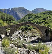 Kasabashi Bridge near Çorovodë
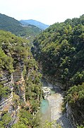 Osum Canyon
 Osum river and Tomorr in the background