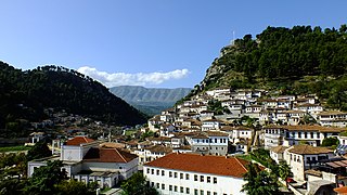
Berat is the ninth most populous city of Albania and the seat of Berat County and Berat Municipality. By air, it is 71 kilometres north of Gjirokastër, 70 kilometres west of Korçë, 70 kilometres south of Tirana, and 33 kilometres east of Fier.

Lushnjë is a city and municipality in west-central Albania. It is located in the County of Fier. The total population is 83,659, in a total area of 372.9 km2 (144.0 sq mi).

Mallakastër is a region and a municipality in Fier County, southwestern Albania. It was created in 2015 by the merger of the present municipalities Aranitas, Ballsh, Fratar, Greshicë, Hekal, Kutë, Ngraçan, Qendër Dukas and Selitë. The seat of the municipality is the town Ballsh. The total population is 27,062, in a total area of 329.37 km2. It is coterminous with the former Mallakastër District.

Berat District was one of the 36 districts of Albania, which were dissolved in July 2000 and replaced by 12 counties. It had a population of 128,410 in 2001, and an area of 915 km2 (353 sq mi). It is in the centre of the country, and its capital was the city of Berat. Another large population centre in this district was Ura Vajgurore. Its territory is now part of Berat County: the municipalities of Berat, Dimal, Poliçan (partly) and Kuçovë (partly).

Kuçovë District was one of the 36 districts of Albania, which were dissolved in July 2000 and replaced by 12 counties. It had a population of 35,571 in 2001, and an area of 112 km2 (43 sq mi), making it the smallest district of Albania. It is in the centre of the country, and its capital was the former municipality of Kuçovë. Its territory is now part of Berat County: the municipality of Kuçovë (partly).

Skrapar District was one of the 36 districts of Albania, which were dissolved in July 2000 and replaced by 12 newly created counties. It had a population of 29,874 in 2001, and an area of 775 km2 (299 sq mi). It was in the centre of the country, and its capital was the town of Çorovodë. Its territory is now part of Berat County: the municipalities of Skrapar and Poliçan (partly).

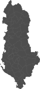
Berat County, officially the County of Berat, is a county in the Southern Region of the Republic of Albania. It is the ninth largest by area and the ninth most populous of the twelve counties, with around 119,450 people within an area of 1,798 km2 (694 sq mi). The county borders the counties of Elbasan to the north, Korçë to the east, Gjirokastër to the south and Fier to the west. It is divided into five municipalities, Berat, Dimal, Kuçovë, Poliçan and Skrapar, with all of whom incorporate twenty-five administrative units.

Patos is a town and a municipality in the County of Fier, Albania. The municipality was formed at the 2015 local government reform by the merger of the former municipalities Patos, Ruzhdie and Zharrëz, that became municipal units. The seat of the municipality is the town Patos. The total population is 22,959, in a total area of 82.59 km2. The population of the former municipality at the 2011 census was 15,397. It is the center of the oil industry in Albania, and is 7 kilometers southeast from the city of Fier.

Skrapar is a municipality in Berat County, southern Albania. It was created in 2015 by the merger of the former municipalities Bogovë, Çepan, Çorovodë, Gjerbës, Leshnjë, Potom, Qendër Skrapar, Vendreshë and Zhepë. The seat of the municipality is the town Çorovodë. The total population is 12,403, in a total area of 832.04 km2. It covers part of the area of the former Skrapar District, without the town Poliçan.

Çorovodë is a town and a former municipality in Berat County, Albania. At the 2015 local government reform it became a subdivision and the seat of the municipality Skrapar. The population at the 2011 census was 4,051. It was the seat of the former Skrapar District.

Kuçovë is a municipality in south-central Albania. It was formed at the 2015 local government reform by the merger of the former municipalities Kozare, Kuçovë, Lumas and Perondi, which all became municipal units. The seat of the municipality is the town of Kuçovë. The total population is 31,262, in a total area of 160.33 km2 (61.90 sq mi). The population of the former municipality at the 2011 census was 12,654.

Klos is a town and a municipality in Mat District, northern center Albania. It was formed at the 2015 local government reform by the merger of the former municipalities Gurrë, Klos, Suç and Xibër, that became municipal units. The seat of the municipality is the town Klos. The total population is 16,618, in a total area of 357.72 km2. The population of the former municipality at the 2011 census was 7,873. Klos lies 28.5 kilometers 'as the crow flies' from Tirana and 14 kilometers (9 mi) from Burrel.

Maliq formerly known as Malik, is a town and a municipality in Korçë County of eastern Albania. It is the smaller of two cities in the district, the other being Korçë, 7 miles (11 km) southeast of Maliq. The current enlarged municipality was formed at the 2015 local government reform by the merger of the former administrative units of Gorë, Libonik, Maliq, Moglicë, Pirg, Pojan and Vreshtas. The seat of the municipality is the town Maliq. The total population is 41,757, in a total area of 656.89 km2. The population of the former municipality at the 2011 census was 4,290. The municipal unit consists of the town Maliq and the villages Kolanec, Goce, Gjyras, Bickë, Fshat Maliq and Plovisht.
Peqin is a town and municipality in Elbasan County, central Albania. The municipality was formed at the 2015 local government reform by the merger of the former municipalities Gjoçaj, Karinë, Pajovë, Peqin, Përparim and Shezë, that became municipal units. The seat of the municipality is the town Peqin. The total population is 26,136, in a total area of 197.90 km2. The population of the former municipality at the 2011 census was 6,353.

Gramsh is a town and a municipality in Elbasan County, central Albania. The municipality was formed at the 2015 local government reform by the merger of the former municipalities Gramsh, Kodovjat, Kukur, Kushovë, Lenie, Pishaj, Poroçan, Skënderbegas, Sult and Tunjë, that became municipal units. The seat of the municipality is the town Gramsh. The total population is 24,231, in a total area of 739.75 km2. The population of the former municipality at the 2011 census was 8,440.

Këlcyrë is a town and a municipality in southern Albania, located on the bank of the river Vjosë. It was formed at the 2015 local government reform by the merger of the former municipalities Ballaban, Dishnicë, Këlcyrë and Sukë, that became municipal units. The seat of the municipality is the town Këlcyrë. The total population is 6,113, in a total area of 304.86 km2. The population of the former municipality at the 2011 census was 2,651. The Vjosë forms a canyon near the town, known as the Këlcyrë Gorge.

Ura Vajgurore, formerly known as Ura e Hasan Beut, is a town and a former municipality in Berat County, central Albania. At the 2015 local government reform it was merged with the former municipalities Cukalat, Kutalli and Poshnjë to form a new municipality, that was officially renamed to Dimal in April 2021. The seat of the municipality Dimal is the town Ura Vajgurore, that was not renamed in 2021. The population at the 2011 census was 7,232.
Tërpan is a village and a former municipality in Berat County, central Albania. At the 2015 local government reform it became a subdivision of the municipality Poliçan. The population at the 2011 census was 1,716.
Vërtop is a village and a former municipality in Berat County, central Albania. At the 2015 local government reform it became a subdivision of the municipality Poliçan. The population at the 2011 census was 4,919.
Dimal is a municipality in Berat County, central Albania. It was formed at the 2015 local government reform by the merger of the former municipalities Cukalat, Kutalli, Poshnjë and Ura Vajgurore, that became municipal units. The seat of the municipality is the town Ura Vajgurore. The total population is 27,295, in a total area of 156.65 km2.