
The Drin is a river in Southern and Southeastern Europe with two distributaries one discharging into the Adriatic Sea and the other one into the Bojana River. Its catchment area extends across Albania, Kosovo, Serbia, Greece, Montenegro and North Macedonia. The river and its tributaries form the Gulf of Drin, an ocean basin that encompasses the northern Albanian Adriatic Sea Coast.

The Lake Prespa is located on the tripoint of North Macedonia, Albania, and Greece. It is a system of two lakes separated by an isthmus: the Great Prespa Lake, divided between the three countries, and the Little Prespa Lake, mostly within Greece. They are the highest tectonic lakes in the Balkans, standing at an elevation of 853 metres (2,799 ft).

Butrint National Park is a national park in Vlorë County, southern Albania. It is located 18 kilometres (11 mi) south of Sarandë. The park encompasses 9,424 hectares (94.24 km2) of hilly terrain with freshwater lakes, wetlands, salt marshes, open plains, reed beds and islands. The park's significance for conservation is reflected in the large number of species with over 1,200 different animals and plants. Its mandate includes the protection of the lake and lagoon of Butrint, the natural channel of Vivari, the islands of Ksamil and as well the archaeological site, that provides valuable remains of ancient civilisations.

Jakupica or Mokra is a mountain range in the central part of North Macedonia. The headwaters of the Axios river, mentioned by Homer as the home of the Paeonians allies of Troy, spring from its flanks.

Lake Skadar – also called Lake Scutari, Lake Shkodër and Lake Shkodra – lies on the border of Albania and Montenegro, and is the largest lake in Southern Europe. It is named after the city of Shkodër which lies at its southeastern coast. It is a karst lake.

Lake Butrint is a salt lagoon south of Saranda, Albania, located in direct proximity of the Ionian Sea. It is surrounded by dense forested hills, rocky coast and complemented by saltwater and freshwater marshlands. The lake has a length of 7.1 km (4.4 mi) and a width of 3.3 km (2.1 mi), with a surface area of 16 km2 (6.18 sq mi). The maximum depth of the lake is 24.4 m (80 ft). At the south, the Vivari Channel connects the lagoon to the sea.
Narta Lagoon is a lagoon of the Adriatic Sea on the Mediterranean Sea in the central coast of Albania. The lagoon extends north of the Bay of Vlorë on the eastern shore of the Strait of Otranto and is separated from the sea by a narrow littoral strip, consisting of an alluvial dune. It has a surface area of 41.8 km2 (16.1 sq mi) with a maximal depth of 1.5 m (4.9 ft).
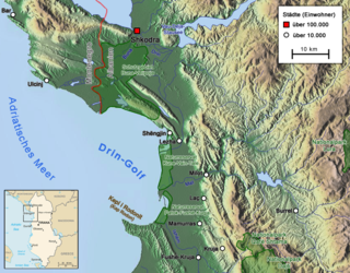
The Gulf of Drin or Bay of Drin is an ocean basin of the Adriatic Sea within the Mediterranean Sea along the northern coast of Albania. Roughly scythe-shaped, it extends immediately from the Delta of the Buna in the north, across the port city of Shëngjin, to the Cape of Rodon in the south. The shoreline of the gulf is a shallow combination of sandy beaches, sand dunes, capes, salty and fresh water wetlands, estuaries, pine and coastal forests, reed beds and coastal meadows.

Lurë-Dejë Mountain National Park is a national park in northeastern Albania, spanning an expanded area of 202.42 km2 (78.15 sq mi) since 2018 by encompassing the entire section of Kunora e Lurës, former Zall-Gjocaj National Park, and Dejë Mountain. The park was originally established in 1966 to protect the various ecosystems and biodiversity as Lura National Park. The altitude vary from 1,500–2,300 m (4,921–7,546 ft). The International Union for Conservation of Nature (IUCN) has listed the park as Category II. Nevertheless, it is described as an important Bird and Plant Area, because it supports significant bird and plant species.

Llogara National Park is a national park centered on the Ceraunian Mountains along the Albanian Riviera in Southwestern Albania, spanning a surface area of 1,769 ha (17.69 km2). The park's terrain includes large alpine meadows, vertical rock faces, precipices and dense forests. The most area of land is covered by forests and was established in 1966 to protect several ecosystems and biodiversity of national importance. The International Union for Conservation of Nature (IUCN) has listed the park as Category II. The region has been recognised as an important Bird and Plant Area, because it support significant numbers of various bird and plant species.

Theth National Park was a national park in northern Albania. In 2022, the park was amalgamated to form the Alps of Albania National Park. Established in 1966, the park covered 2,630 ha (26.3 km2) and is centred on the Albanian Alps, encompassing the larger portion of Shala Valley. The park was established to protect various ecosystems and biodiversity and the cultural and historical heritage of the region. It is dominated by high terrain, with a wide variety of natural features including valleys, rivers, mountains, waterfalls, dense forests and several rock formations. The International Union for Conservation of Nature (IUCN) has listed the park as Category II. Notably, the region has been also identified as an important Bird and Plant Area. In 2017, Theth has been further declared a Protected Historic Center.

Despite being a relatively small country, Albania is exceedingly rich in biodiversity. Its ecosystems and habitats support over 5,550 species of vascular and non-vascular plants and more than 15,600 species of coniferous and non-coniferous evergreens, most of which are threatened at global and European levels. The country has made recent efforts to expand its network of protected areas which now total 799 protected areas, including: 11 national parks, 1 marine park, 23 managed nature reserves, 11 protected landscapes, 4 World Heritage Sites, 4 Ramsar sites and other protected areas of various categories, that when combined, account for 21.36% of the territory. Furthermore 1 biosphere reserve, 45 important plant areas and 16 important bird areas are found in Albania.

Karaburun-Sazan Marine Park is a marine park in the Vlorë County of southwestern Albania. The marine park encompasses over 125.70 km2 (48.53 sq mi) and comprises the boundaries of both the Peninsula of Karaburun and the Island of Sazan. It is home to a vast array of landforms, including mountains, caves, islands, depressions, bays, cliffs, canyons and rocky coasts, all contributing to an exceptionally considerable biological diversity. The marine park has been identified as an Important Bird and Plant Area, because it supports immense bird and plant species. Containing ecosystems and habitats that are specific to the Mediterranean Basin, the convention of Barcelona has classified the marine park as a Specially Protected Areas of Mediterranean Importance.

For a small country, Albania is characterised by a considerable wealth of terrestrial and marine ecosystems and habitats with contrasting floral and faunal species, defined in an area of 28,748 square kilometres. Most of the country is predominantly of Mediterranean character, comprehending the country's center and south, while the alpine affinity is more visible in the northeast.

Prespa National Park is a national park situated in southeastern Albania on the border triangle shared with Greece and North Macedonia. At approximately 277.5 km2 (107.1 sq mi), the park encompasses the country's sections of the Great and Small Prespa Lake. It is considerably characterised by high mountains, narrow islands, vast freshwater wetlands, salt marshes, meadows, reed beds and dense forests.

Divjakë-Karavasta National Park is a national park in western Albania, sprawling across the Myzeqe Plain in the direct proximity to the Adriatic Sea. The park spans a territory of 222.3 square kilometres (22,230 ha) containing remarkable features such as wetlands, salt marshes, coastal meadows, floodplains, woodlands, reed beds, forests and estuaries. Because of the park's important and great availability of bird and plant species, it has been identified as an important Bird and Plant Area of international importance.

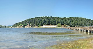
The Kunë-Vain-Talë-Patok-Fushëkuqe-Ishëm Nature Reserve is a nature park located within the Lezhë County forming the Drin river delta and facing the Adriatic Sea in northern Albania. It spans an area of 43.93 km2 (16.96 sq mi). The area is the first protected area to be established in Albania as a hunting reserve in July 1940. The current nature reserve was established in 2010 encompassing the Kunë Island, the Kunë-Vain lagoon, the woodlands, and several ecosystems. Notably, it has been also identified as an Important Bird Area by BirdLife International.

The Albanian Adriatic Sea Coast stretches in the Southeastern Adriatic Sea beginning at the Gulf of Drin in the north, across the port cities of Shëngjin, Durrës and Vlorë, to the Bay of Vlorë in the south, where the Albanian Riviera as well as the Albanian Ionian Sea Coast begins.
The Albanian Ionian Sea Coast is a coastline of the Northeastern Ionian Sea, that encompasses the southwestern border of the Republic of Albania, stretching from the southern half of Karaburun Peninsula, across the historical region of Labëria, the city of Sarandë, the mountains of the Ceraunians and the Albanian Riviera, to the Lake of Butrint, where the Strait of Corfu separates the country from Greece.

The Buna River-Velipojë Protected Landscape is a protected landscape area in northwestern Albania, encompassing the estuary of Drin, the lagoon of Viluni, the river of Buna with its estuary, and the gulf of Drin that runs across the city of Velipojë alongside the Adriatic Sea.


