Protected areas of Albania

Last updated
Network of protected areas in Albania (2020) Harta e Zonave te Mbrojtura (2020).svg
Network of protected areas in Albania (2020)

Despite being a relatively small country, Albania is exceedingly rich in biodiversity. Its ecosystems and habitats support over 5,550 species of vascular and non-vascular plants and more than 15,600 species of coniferous and non-coniferous evergreens, most of which are threatened at global and European levels. The country has made recent efforts to expand its network of protected areas which now include: 11 national parks, 1 marine park, 718 nature monuments, 23 managed nature reserves, 11 protected landscapes, 4 World Heritage Sites, [2] 4 Ramsar sites [3] and other protected areas of various categories, that when combined, account for 21.36% of the territory. [4] Furthermore, a biosphere reserve, 45 important plant areas and 16 important bird areas are found in the country. [5] [6]

Contents

Meanwhile, the central government has proclaimed the Coastline and the Tirana Greenbelt as areas of national importance. [7]

At present, protected areas are constantly under threat by illegal logging, forest fires and the construction of hydroelectric power plants which have prompted ongoing protests from environmentalists and civil society. [8]

The national policy for governing and the management of protected areas is implemented by the Ministry of Environment and Tourism through the National Agency of Protected Areas (AKZM). [9]

Strict nature reserves

(Cat. Ia) Strict nature reserves are limited areas of ecological significance, preserved and protected for scientific purposes, to safeguard the living world and all its cultural and natural values. Two such areas in the country have this designation: Gashi Valley and Rrajcë Strict Nature Reserve.

   World Heritage Site
NameImageDesignated IUCN cat. AreaMap
Gashi Valley Peaks of the Balkans - 40 (24026470167).jpg 15 January 1996Ia3,000 hectares (30 km2)
Albania relief location map.svg
Green pog.svg
Rrajcë Strict Nature Reserve Parku Kombetare Shebenik-Jabllanice Unesco,Rrajce.jpg 7 July 2017Ia4,700 hectares (47 km2)
Albania relief location map.svg
Green pog.svg

National parks

(Cat. II) National parks are vast areas of land or water, typically not less than 1000 hectares in size, that possess exceptional scientific, ecological, and educational values and are kept away from strenuous human activities. These parks are protected and monitored to maintain the ecological balance of their ecosystems, to promote scientific research, and to provide visitors with spiritual and educational experiences, in compliance with environmental and cultural regulations. A total of 12 national parks, encompassing a surface area of 313,950.77 hectares (3,140 km2), occupy 10.92% of the country's territory. [10] [11]

   World Heritage Site
   Ramsar wetland or a marine protected area
LogoNameImageDesignated IUCN cat. Area [12] Map
Parku Kombetar Butrint.svg Butrint National Park Albanien 1978 32.jpg 2 March 2000 [13] II8,622.2 hectares (86.222 km2)
Albania relief location map.svg
Green pog.svg
Parku Kombetar Prespa.svg Prespa National Park Liqeni Prespes. Ishulli Mali Gradit. Korce. Albania.jpg 18 February 1999 [14] II27,613.05 hectares (276.1305 km2)
Albania relief location map.svg
Green pog.svg
Parku Kombetar Divjake-Karavasta.svg Divjakë-Karavasta National Park Karavastra National Park (30911403928).jpg 19 October 2007 [15] II22,389.08 hectares (223.8908 km2)
Albania relief location map.svg
Green pog.svg
Parku Kombetar Llogara.svg Llogara National Park Llogora Tourist Village.jpg 21 November 1966 [16] II1,769.20 hectares (17.6920 km2)
Albania relief location map.svg
Green pog.svg
Parku Kombetar Shebenik.svg Shebenik National Park Liqeni i Fushe Studnes.jpg 21 May 2008 [17] II34,507.90 hectares (345.0790 km2)
Albania relief location map.svg
Green pog.svg
Alps of Albania National Park The Albanian Alps (31693684978).jpg 26 January 2022 [18] II82,844.65 hectares (828.4465 km2)
Albania relief location map.svg
Green pog.svg
Parku Kombetar Mali i Tomorrit.svg Tomorr Mountain National Park Tyrbe on Mount Tomorr - Mapillary (594b8tPNXU8Xzg9iPMoobQ).jpg 18 July 2012 [19] II27,185.5 hectares (271.855 km2)
Albania relief location map.svg
Green pog.svg
Lurë-Dejë Mountain National Park Liqeni i Kallabes, Lura.jpg 21 November 1966 [20] II19,288.88 hectares (192.8888 km2)
Albania relief location map.svg
Green pog.svg
Parku Kombetar Mali i Dajtit.svg Dajti Mountain National Park Mali i Dajtit.jpg 21 June 2006 [21] II28,561.85 hectares (285.6185 km2)
Albania relief location map.svg
Green pog.svg
Parku Kombetar Bredhi i Hotoves-Dangelli.svg Fir of Hotovë-Dangëlli National Park Bredhi i Hotoves.jpg 17 December 2008 [22] II36,003.76 hectares (360.0376 km2)
Albania relief location map.svg
Green pog.svg
Parku Kombetar i Lumit te Eger Vjosa.svg Vjosa Wild River National Park Permet District, Albania - panoramio (3).jpg 15 March 2023 [23] II12,727 hectares (127.27 km2)
Albania relief location map.svg
Green pog.svg
Parku Detar Karaburun-Sazan.svg Karaburun-Sazan Marine Park Jonufer vlora albania 2016.jpg 28 April 2010 [24] II12,437.7 hectares (124.377 km2)
Albania relief location map.svg
Green pog.svg

Natural monuments

(Cat. III) Natural monuments typically consist of natural entities and habitats that cover a limited area of land, usually no more than 50 hectares. These areas are recognized for their significant scientific, ecological, cultural, historical, aesthetic, and religious values. They may include both living organisms, such as rare or endemic species of trees and plants, as well as non-living environmental features like unique geological formations created by wind, ice, or water erosion, such as: karst springs and lakes, glacial lakes, wetlands, and sources of mining or thermal activity. A total of 718 nature monuments have been designated (government decision no. 303, dated 10.05.2019). [25]

NameImageDesignated IUCN cat. AreaMap
Tulipa Albanica Habitat Lendina e tulipaneve.JPG 13 March 2023III35.5 hectares (0.355 km2)
Albania relief location map.svg
Green pog.svg

Managed nature reserves

(Cat. IV) Managed nature reserves are protected areas of land or water that are of local and regional importance. These areas are maintained through proper management to preserve the species, habitats, and other unique natural phenomena, with the aim of enhancing their quality and utilizing them for recreational and entertainment purposes, as well as for studies, educational, and cultural activities. A total of 23 managed nature reserves, encompassing a surface area of 216,024.68 hectares (2,160 km2), occupy 7.5% of the territory. [26]

NameImageDesignated IUCN cat. AreaMap
Fir of Kardhiq Nature Park Kardhiqit River, Albania, September 2022 01.jpg 15 January 1996IV4,303.6 hectares (43.036 km2)
Albania relief location map.svg
Green pog.svg
Fir of Sotirë Nature Park Pejsazh nga Ujevara e Sotires.jpg 15 January 1996IV4,927.67 hectares (49.2767 km2)
Albania relief location map.svg
Green pog.svg
Fir of Zhulat Nature Park 26 January 2022IV936.2 hectares (9.362 km2)
Albania relief location map.svg
Green pog.svg
Cangonj Nature Park 27 July 1977IV250.3 hectares (2.503 km2)
Albania relief location map.svg
Green pog.svg
Dardhë-Xhyrë Nature Park 15 January 1996IV400.3 hectares (4.003 km2)
Albania relief location map.svg
Green pog.svg
Gërmenj Nature Park 15 January 1996IV1,410 hectares (14.1 km2)
Albania relief location map.svg
Green pog.svg
Karaburun Nature Reserve Bunkere bregdetar Karaburun 2.jpg 27 July 1977IV17,490.7 hectares (174.907 km2)
Albania relief location map.svg
Green pog.svg
Korab-Koritnik Nature Park Mali Korabit.jpg 21 December 2011IV53,850 hectares (538.5 km2)
Albania relief location map.svg
Green pog.svg
Kunë-Vain-Talë-Patok-Fushëkuqe-Ishëm Nature Park Kune-Vaine-Tale Nature Park 2019 02.jpg 28 April 2010IV8,092.3 hectares (80.923 km2)
Albania relief location map.svg
Green pog.svg
Gjergjevica Lagoon Nature Reserve 26 January 2022IV2,966.3 hectares (29.663 km2)
Albania relief location map.svg
Green pog.svg
Shala Lagoon Nature Park Porta e Shales (Lotaj)..jpg 26 January 2022IV10,619.35 hectares (106.1935 km2)
Albania relief location map.svg
Green pog.svg
Munellë Nature Park E851 WikipediaWeekendTirana2015 MunellaMirditaMountains 728.JPG 26 January 2022IV20,760.05 hectares (207.6005 km2)
Albania relief location map.svg
Green pog.svg
Mali me Gropa-Bizë-Martanesh Nature Park Vajkal, Bulqize.jpg 31 January 2007IV26,043.34 hectares (260.4334 km2)
Albania relief location map.svg
Green pog.svg
Lake Ulza Nature Park Lake Ulza, Albania.jpg 3 April 2013IV4,205.15 hectares (42.0515 km2)
Albania relief location map.svg
Green pog.svg
Polis Nature Park 15 January 1996IV45.1 hectares (0.451 km2)
Albania relief location map.svg
Green pog.svg
Porto Palermo Nature Park Porto Palermo, Albanian Riviera 2016.jpg 29 July 2022IV1,694.98 hectares (16.9498 km2) [27]
Albania relief location map.svg
Green pog.svg
Shtamë Pass Nature Park Qafe Shtame National Park 2017 01.jpg 15 January 1996IV6,864.36 hectares (68.6436 km2)
Albania relief location map.svg
Green pog.svg
Lake Shkodër Nature Reserve Liqeni Shkoder 01.jpg 2 November 2005IV24,049.75 hectares (240.4975 km2)
Albania relief location map.svg
Green pog.svg
Stravaj and Sopot Nature Park Stravaj.jpg 15 January 1996IV1,548.9 hectares (15.489 km2)
Albania relief location map.svg
Green pog.svg
Blue Eye Nature Park Syri Kalter 1.jpg 15 January 1996IV293.3 hectares (2.933 km2)
Albania relief location map.svg
Green pog.svg
Zagori Nature Park Albanian landscape (25743349628).jpg 26 January 2022IV24,607.63 hectares (246.0763 km2)
Albania relief location map.svg
Green pog.svg
Balloll Nature Park 27 July 1977IV323.3 hectares (3.233 km2)
Albania relief location map.svg
Green pog.svg
Bogovë Nature Park Bogova Waterfall - Mapillary (urmOoawelw6W67SolMO-zQ).jpg 27 July 1977IV342.1 hectares (3.421 km2)
Albania relief location map.svg
Green pog.svg

Protected landscapes

(Cat. V) Protected landscapes and seascapes are primarily managed for the preservation of landscape values and to provide recreational opportunities for relaxation and entertainment. This category includes areas with residential centers that allow activities like agriculture, horticulture, forestry, fishing, etc., both on land and in sea. The goal is to preserve the quality of landscapes and the harmonious interaction of human activity in them, and maintain the biological diversity they host. A total of 11 protected landscapes, encompassing a surface area of 84,746.69 hectares (847.5 km2), occupy 2.94% of the territory.

  Part of the Emerald network
NameImageDesignated IUCN cat. AreaMap
Bjeshka e Oroshit Protected Landscape Gryke-Orosh, Mirdite, Albania 2018-04 02.jpg 15 January 1996V4,646.7 hectares (46.467 km2)
Albania relief location map.svg
Green pog.svg
Fir of Drenovë-Sinicë Protected Landscape Korce District, Albania - panoramio (1).jpg 21 November 1966V2,065.8 hectares (20.658 km2)
Albania relief location map.svg
Green pog.svg
Guri i Nikës-Lenie-Valamarë Protected Landscape Perballe Gurit te Nikes 06.jpg 15 January 1996V5,172.7 hectares (51.727 km2)
Albania relief location map.svg
Green pog.svg
Qafë Bush-Kuturman Protected Landscape Lagja Gjura.jpg 27 July 1977V4,159.7 hectares (41.597 km2)
Albania relief location map.svg
Green pog.svg
Rrushkull Protected Landscape Kisha e Skenderbeut ne Kep te Rodonit.jpg 16 December 1995V579.5 hectares (5.795 km2)
Albania relief location map.svg
Green pog.svg
Bisht Kamëz Protected Landscape 28 December 2020V491.5 hectares (4.915 km2)
Albania relief location map.svg
Green pog.svg
Nikolicë Protected Landscape 15 January 1996V510 hectares (5.1 km2)
Albania relief location map.svg
Green pog.svg
Krastë-Verjon Protected Landscape 26 July 2018V1,469.24 hectares (14.6924 km2)
Albania relief location map.svg
Green pog.svg
Lake Ohri Protected Landscape Lin and lake.jpg 18 February 1999V28,000 hectares (280 km2)
Albania relief location map.svg
Green pog.svg
Pishë Poro-Nartë Protected Landscape Zvernec, Albania - Narta Lagoon 02.jpg 22 October 2004V15,972.7 hectares (159.727 km2)
Albania relief location map.svg
Green pog.svg
Buna River-Velipojë Protected Landscape Lumi i Bunes, burimi nga Liqeni i Shkodres 01.jpg 2 November 2005V21,678.85 hectares (216.7885 km2)
Albania relief location map.svg
Green pog.svg

See also

Related Research Articles

<span class="mw-page-title-main">Lurë-Dejë Mountain National Park</span> National park in Albania

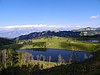
Lurë-Dejë Mountain National Park is a national park in northeastern Albania, spanning an expanded area of 202.42 km2 (78.15 sq mi) since 2018 by encompassing the entire section of Kunora e Lurës, former Zall-Gjocaj National Park, and Dejë Mountain. The park was originally established in 1966 to protect the various ecosystems and biodiversity as Lura National Park. The altitude vary from 1,500–2,300 m (4,921–7,546 ft). The International Union for Conservation of Nature (IUCN) has listed the park as Category II. Nevertheless, it is described as an important Bird and Plant Area, because it supports significant bird and plant species.

<span class="mw-page-title-main">Llogara National Park</span> National park and a tourist attraction in Albania

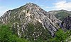
Llogara National Park is a national park centered on the Ceraunian Mountains along the Albanian Riviera in Southwestern Albania, spanning a surface area of 1,769 ha (17.69 km2). The park's terrain includes large alpine meadows, vertical rock faces, precipices and dense forests. The most area of land is covered by forests and was established in 1966 to protect several ecosystems and biodiversity of national importance. The International Union for Conservation of Nature (IUCN) has listed the park as Category II. The region has been recognised as an important Bird and Plant Area, because it support significant numbers of various bird and plant species.

<span class="mw-page-title-main">Dajti Mountain National Park</span> National park and a tourist attraction in Albania

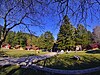
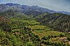
Dajti Mountain National Park is a national park established in 1966 in central Albania, spanning an area of 293.84 km2 (113.45 sq mi) since 2006. The park is 40 km (25 mi) east of the Adriatic Sea and 26 km (16 mi) east of Tirana. The area is under shared jurisdiction between Albanian Agency of Protected Areas (AKZM) and Tirana Municipality Parks and Recreation Agency (APR). It is adjacent to Shtamë Pass Nature Park to the northwest, Kraste-Verjon Protected Landscape to the west, and Mali me Gropa-Bizë-Martanesh Protected Landscape to the east. The park is marked by an extremely fragmented, rugged topography which creates favourable conditions for a great diversity of ecosystems and biodiversity.

<span class="mw-page-title-main">Shebenik National Park</span> Protected area in Albania

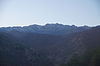
Shebenik National Park is a national park in eastern Albania adjacent to the border with North Macedonia. It encompasses 34,507.9 hectares (345.079 km2) and is specifically marked by a mountainous landscape supplied with glacial lakes, valleys, dense coniferous and deciduous forests and alpine meadows and pastures. Elevations in the park vary from 300 metres to over 2,200 metres above the Adriatic at the peak of Shebenik and Jabllanica, hence the name. It dwells a number of endangered species that are fast becoming rare in Southern Europe, including the brown bear, gray wolf and balkan lynx. The abundance in wildlife can in part be explained by the variety of vegetation types and remote location.

<span class="mw-page-title-main">Theth National Park</span> National park in Albania

Theth National Park was a national park in northern Albania. In 2022, the park was amalgamated to form the Alps of Albania National Park. Established in 1966, the park covered 2,630 ha (26.3 km2) and is centred on the Albanian Alps, encompassing the larger portion of Shala Valley. The park was established to protect various ecosystems and biodiversity and the cultural and historical heritage of the region. It is dominated by high terrain, with a wide variety of natural features including valleys, rivers, mountains, waterfalls, dense forests and several rock formations. The International Union for Conservation of Nature (IUCN) has listed the park as Category II. Notably, the region has been also identified as an important Bird and Plant Area. In 2017, Theth has been further declared a Protected Historic Center.

<span class="mw-page-title-main">Valbona Valley</span> National park in Albania

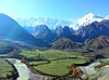
The Valbona Valley National Park was a national park inside the Albanian Alps in northern Albania. In 2022, the park was amalgamated to form the Alps of Albania National Park. The park covers a total area of 80 km2 (31 sq mi), encompassing Valbona River and its surrounding areas with mountainous terrain, alpine landscapes, glacial springs, deep depressions, various rock formations, waterfalls and the Valbona Valley with its dense coniferous and deciduous forest. It is characterized by its very remote areas which have a large preserved ecosystem all of which is primarily untouched with pristine quality. This vast pristine ecosystem is the centrepiece of what has been referred to as the Albanian Miracle of the Alps.

<span class="mw-page-title-main">Shtamë Pass Nature Park</span> Protected area in Albania

Shtamë Pass Nature Park resides in the edge of the mountain chain north of Tirana, about 25 kilometers east of Kruja. The park is named after the Qafë-Shtamë passage, and has an area of 6,864.36 hectares, with a beautiful mountain scenery consisting mainly of pine forests, some small lakes and major water sources. The national park was established in 1996 by the Albanian government and transformed in 2022 into a larger nature park. It is becoming lately a popular attraction for hiking.

<span class="mw-page-title-main">Fir of Drenovë-Sinicë Protected Landscape</span> Protected area in Albania

The Fir of Drenovë-Sinicë Protected Landscape is a protected landscape near Korçë in eastern Albania, with an area of 10.3 km2 (4.0 sq mi).

<span class="mw-page-title-main">Prespa National Park (Albania)</span> National park and tourist attraction in southeastern Albania

Prespa National Park is a national park situated in southeastern Albania on the border triangle shared with Greece and North Macedonia. At approximately 277.5 km2 (107.1 sq mi), the park encompasses the country's sections of the Great and Small Prespa Lake. It is considerably characterised by high mountains, narrow islands, vast freshwater wetlands, salt marshes, meadows, reed beds and dense forests.

<span class="mw-page-title-main">Divjakë-Karavasta National Park</span> National park in western Albania

Divjakë-Karavasta National Park is a national park in western Albania, sprawling across the Myzeqe Plain in the direct proximity to the Adriatic Sea. The park spans a territory of 222.3 square kilometres (22,230 ha) containing remarkable features such as wetlands, salt marshes, coastal meadows, floodplains, woodlands, reed beds, forests and estuaries. Because of the park's important and great availability of bird and plant species, it has been identified as an important Bird and Plant Area of international importance.

<span class="mw-page-title-main">Tomorr Mountain National Park</span> National park and a tourist attraction in Albania

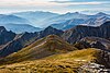
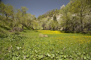
Tomorr Mountain National Park is a national park founded in 1956 that lies in southern Albania, nestled in the central and higher portions of the Tomorr massif, spanning an area of 261.06 km2 (100.80 sq mi) since 2012, and expanded to include its quarry areas since 2019. The park covers a territory of 26,106 ha. The area falls within the Berat County and only 1,278 ha inside the Elbasan County. The park was established in 1956 and is considered one of the most important protected areas for the maintenance of mountainous biodiversity and ecosystem integrity at the national level. The park has been recognised as an Important Plant Area of international importance by Plantlife.

<span class="mw-page-title-main">Korab-Koritnik Nature Park</span> Protected area and a tourist attraction in Albania

The Korab-Koritnik Nature Park is a nature park in eastern Albania and forms a section of the European Green Belt, which serves as a retreat for endangered animal and plant species. It encompasses 55,550 hectares (555.5 km2) of alpine mountainous terrain, with valleys, rivers, glacial lakes, caves, canyons, dense coniferous and deciduous forest. The International Union for Conservation of Nature (IUCN) has listed the park as Category IV. Both, Koritnik and Korab has been recognised as an Important Plant Area of international importance by Plantlife.

<span class="mw-page-title-main">Kunë-Vain-Talë-Patok-Fushëkuqe-Ishëm Nature Park</span> Nature park in Lezhë County and a tourist attraction in Albania

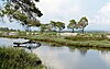
The Kunë-Vain-Talë-Patok-Fushëkuqe-Ishëm Nature Reserve is a nature park located within the Lezhë County forming the Drin river delta and facing the Adriatic Sea in northern Albania. It spans an area of 43.93 km2 (16.96 sq mi). The area is the first protected area to be established in Albania as a hunting reserve in July 1940. The current nature reserve was established in 2010 encompassing the Kunë Island, the Kunë-Vain lagoon, the woodlands, and several ecosystems. Notably, it has been also identified as an Important Bird Area by BirdLife International.

<span class="mw-page-title-main">Mali me Gropa-Bizë-Martanesh Nature Park</span>

The Mali me Gropa-Bizë-Martanesh Nature Park is a habitat or species management area in central Albania adjacent with the border with Dajti National Park. It covers a surface area of 25,266.42 hectares (252.6642 km2). It is situated in Dibër and Tirana County with three municipalities, Xibër, Martanesh and Shëngjergj, and several villages within its territory. The International Union for Conservation of Nature (IUCN) has listed the landscape as Category V. The region has been as well recognised as an Important Plant Area of international importance by Plantlife.

<span class="mw-page-title-main">Albanian Ionian Sea Coast</span>

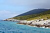
The Albanian Ionian Sea Coast is a coastline of the Northeastern Ionian Sea, that encompasses the southwestern border of the Republic of Albania, stretching from the southern half of Karaburun Peninsula, across the historical region of Labëria, the city of Sarandë, the mountains of the Ceraunians and the Albanian Riviera, to the Lake of Butrint, where the Strait of Corfu separates the country from Greece.

<span class="mw-page-title-main">Bay of Grama</span> Bay in the Ionian sea and a tourist attraction in Albania

The Bay of Grama is a bay in the Ionian Sea situated along the Albanian Ionian Sea Coast on the Mediterranean Sea in Southern Europe. It is one of many bays of the western Ceraunian Mountains along the Albanian Riviera south of the Karaburun Peninsula. The bay is primarily known as a touristic place, and for the engraved inscriptions in the surrounding coastal cliffs as its name relieves.

<span class="mw-page-title-main">National Agency of Protected Areas (Albania)</span>

The National Agency of Protected Areas is a government agency in Albania. Its main duties are focused on the management, protection, development, expansion and operation of the protected areas in the country, which today account for about 21.3% of the territory of Albania. AKZM was established on February 4, 2015, and took many of the functions and duties of former local Forestry Police which was abolished. The newly created local Protected Areas Administrations (AdZM) on a county level are: AdZM Tiranë, AdZM Durrës, AdZM Shkodër, AdZM Kukës, AdZM Dibër, AdZM Lezhë, AdZM Elbasan, AdZM Berat, AdZM Fier, AdZM Korçë, AdZM Vlorë, AdZM Gjirokastër.

<span class="mw-page-title-main">Vjosa Wild River National Park</span> National park in Albania

Vjosa Wild River National Park is a national park located in southern Albania. The Vjosa River is Europe's first Wild River National Park that was designated on 15 March 2023. The park was declared a natural ecosystem by decision of the Council of Ministers, in compliance with Law 81/2017 "On Protected Areas". The river valley is considered Albania's biodiversity hotspot, offering ideal aquatic habitats for over 1,100 species of wildlife, including otters, the endangered Egyptian vulture and the critically endangered Balkan lynx, of which only 15 are estimated to remain.

<span class="mw-page-title-main">Lake Ulza Nature Park</span> Regional park and a tourist attraction in Albania

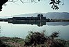
Lake Ulza Nature Park is a regional nature park located in Mat, Albania. It covers a surface area of 4206 hectares and is located near the town of Burrel in the central part of the country.

References

  1. "Map" (PDF). gazetasi.al. Retrieved 2021-04-13.
  2. UNESCO. "Albania". whc.unesco.org.
  3. Ramsar Convention. "ALBANIA" (PDF). ramsar.org.
  4. "WDPA - Designation Display". Archived from the original on 2011-01-12. Retrieved 2010-11-28.
  5. "Important Plant Areas of the south and east Mediterranean region" (PDF). portals.iucn.org. p. 76.
  6. BirdLife International. "Albania". datazone.birdlife.org.
  7. "Baza Ligjore | APR Tirana" . Retrieved 2021-02-20.
  8. "FLETORJA ZYRTARE" (PHP). planifikimi.gov.al. 23 May 2017. Retrieved 2021-04-13.
  9. "Zonat e Mbrojtura në Shqipëri". akzm.gov.al. Retrieved 10 April 2023.
  10. "Për miratimin e ndryshimit të statusit dhe të sipërfaqes së ekosistemeve natyrore park kombëtar (kategoria ii) të zonave të mbrojtura mjedisore". Qendra e Botimeve Zyrtare. 26 January 2022.
  11. "Initial assessment of protected areas in Albania" (PDF). iucn.org. pp. 1–12.
  12. "Vendime të miratuara në mbledhjen e Këshillit të Ministrave, datë 26 Janar 2022" (in Albanian). Kryeministria. 26 January 2022. Archived from the original on 24 March 2023. Retrieved 24 March 2023.
  13. "Parku Kombëtar i Butrintit – Plani i Menaxhimit të Integruar (2020-2030)" (PDF). kultura.gov.al. Retrieved 23 September 2019.
  14. "Parku Kombëtar i Prespës pajiset me sinjalistikën vertikale". ata.gov.al. Agjencia Telegrafike Shqiptare. 5 December 2021.
  15. "Parku i Karavastasë: Një destinacion ndryshe". monitor.al. Retrieved 28 January 2017.
  16. "Final Report on the Study on Landscape of the National Park Llogara" (PDF). United Nations Development Program. Retrieved 25 March 2020.
  17. Brazhda, Fatmir. "Parku Kombëtar Shebenik-Jabllanicë". albNatyra. Retrieved 21 May 2008.
  18. "Vendime të miratuara në mbledhjen e Këshillit të Ministrave". kryeministria.al. Retrieved 26 January 2022.
  19. "PVKM për miratimin e ndryshimit në sipërfaqe të ekosistemit natyror "Mali i Tomorrit" i shpallur Park Kombëtar". konsultimipublik.gov.al. Ministria e Turizmit dhe Mjedisit. Retrieved 16 July 2021.
  20. Parmentier, Laurian (15 November 2022). "Integrative analysis reveals cryptic speciation linked to habitat differentiation within Albanian populations of the anomalous blues (Lepidoptera, Lycaenidae, Polyommatus Latreille, 1804)". Comparative Cytogenetics.
  21. "Decision no.715 dated 23.06.2009 amending Decision No.402 dated 21.6.2006 proclaiming National Park the Dajti Mountain natural ecosystem". FAOLEX. Retrieved 23 June 2009.
  22. "Regulation No. 1631 proclaiming the natural ecosystem of Bredhi I Hotoves-Dangelli as national park". UNEP. Retrieved 17 December 2008.
  23. Katanich, Doloresz (15 March 2023). "'Conserved forever': Albania's Vjosa officially declared Europe's first wild river national park". Euronews.
  24. "10 years Karaburun-Sazan National Marine Park". UNDP. Retrieved 28 April 2020.
  25. "40-vjetori i Monumenteve të Natyrës". inca-al.org. Institute for Nature Conservation in Albania. Retrieved 4 May 2021.
  26. "Rrjeti i Zonave të Mbrojtura në Shqipëri" (PDF). cbd.int. Retrieved 1 January 2014.
  27. "UNEP/MAP welcomes the announcement of a protected area in Porto-Palermo Bay in Albania". United Nations Environment Programme (UNEP). 2 September 2022. Archived from the original on 5 September 2023. Retrieved 5 September 2023.