Erosion is the action of surface processes that removes soil, rock, or dissolved material from one location on the Earth's crust and then transports it to another location where it is deposited. Erosion is distinct from weathering which involves no movement. Removal of rock or soil as clastic sediment is referred to as physical or mechanical erosion; this contrasts with chemical erosion, where soil or rock material is removed from an area by dissolution. Eroded sediment or solutes may be transported just a few millimetres, or for thousands of kilometres.

Albania is a country in Southeastern Europe that lies along the Adriatic and Ionian Seas, with a coastline spanning approximately 476 km (296 mi). Situated on the Balkan Peninsula, it is one of the most mountainous countries in Europe. It is bounded by Montenegro to the northwest, Kosovo to the northeast, North Macedonia to the east and Greece to the southeast and south.

Physical geography is one of the three main branches of geography. Physical geography is the branch of natural science which deals with the processes and patterns in the natural environment such as the atmosphere, hydrosphere, biosphere, and geosphere. This focus is in contrast with the branch of human geography, which focuses on the built environment, and technical geography, which focuses on using, studying, and creating tools to obtain, analyze, interpret, and understand spatial information. The three branches have significant overlap, however.

Tourism in Albania has been a key element to the country's economic activity and is constantly developing. Albania is characterized by its rich archaeological and cultural heritage dating back to the classical period when Illyrians and Ancient Greeks inhabited the region. Over the course of history, the territory of Albania was occupied and populated by Romans, Byzantines, Venetians and Ottomans. Notably the country features unspoiled beaches, mountainous landscapes, traditional cuisine, archaeological artifacts, unique traditions, low prices and the wild atmosphere of the countryside.
Landforms are categorized by characteristic physical attributes such as their creating process, shape, elevation, slope, orientation, rock exposure, and soil type.

The Driftless Area, also known as Bluff Country and the Paleozoic Plateau, is a topographical and cultural region in the Midwestern United States that comprises southwestern Wisconsin, southeastern Minnesota, northeastern Iowa, and the extreme northwestern corner of Illinois. The Driftless Area is a USDA Level III Ecoregion: Ecoregion 52. The Driftless Area takes up a large portion of the Upper Midwest forest–savanna transition. The Blufflands refers to the eastern section of the Driftless area in Minnesota, due to the steep bluffs and cliffs around the river valleys. The western half is known as the Rochester Plateau, which is flatter than the Blufflands. The Coulee Region refers to the southwestern part of the Driftless Area in Wisconsin. It is named for its numerous ravines.

Orjen is a transboundary Dinaric Mediterranean limestone mountain range, located between southernmost Bosnia and Herzegovina and southwestern Montenegro.

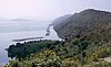
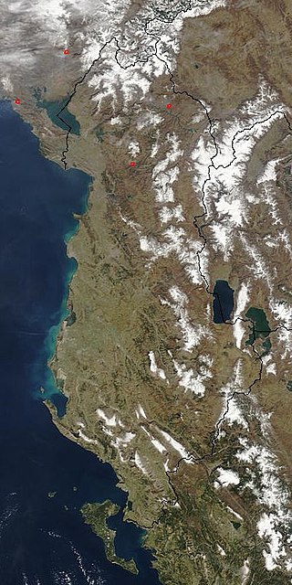
Lake Skadar – also called Lake Scutari, Lake Shkodër and Lake Shkodra – lies on the border of Albania and Montenegro, and is the largest lake in Southern Europe. It is named after the city of Shkodër which lies at its southeastern coast. It is a karst lake.
A lake is a naturally occurring, relatively large and fixed body of water on the Earth's surface. It is localized in a basin or interconnected basins surrounded by dry land. Lakes lie completely on land and are separate from the ocean, although, like the much larger oceans, they form part of the Earth's water cycle by serving as large standing pools of storage water. Most lakes are freshwater and account for almost all the world's surface freshwater, but some are salt lakes with salinities even higher than that of seawater. Lakes vary significantly in surface area and volume.
Earth science or geoscience includes all fields of natural science related to the planet Earth. This is a branch of science dealing with the physical, chemical, and biological complex constitutions and synergistic linkages of Earth's four spheres: the biosphere, hydrosphere/cryosphere, atmosphere, and geosphere. Earth science can be considered to be a branch of planetary science but with a much older history.

Lurë-Dejë Mountain National Park is a national park in northeastern Albania, spanning an expanded area of 202.42 km2 (78.15 sq mi) since 2018 by encompassing the entire section of Kunora e Lurës, former Zall-Gjocaj National Park, and Dejë Mountain. The park was originally established in 1966 to protect the various ecosystems and biodiversity as Lura National Park. The altitude vary from 1,500–2,300 m (4,921–7,546 ft). The International Union for Conservation of Nature (IUCN) has listed the park as Category II. Nevertheless, it is described as an important Bird and Plant Area, because it supports significant bird and plant species.

The environment of Albania is characterised by unique flora and fauna and a variety of landforms contained within a small nation. It also consists of different ecoregions, which represent the natural geographical ecosystem, water systems, weather, renewable resources and influences upon them.

Shebenik National Park is a national park in eastern Albania adjacent to the border with North Macedonia. It encompasses 34,507.9 hectares (345.079 km2) and is specifically marked by a mountainous landscape supplied with glacial lakes, valleys, dense coniferous and deciduous forests and alpine meadows and pastures. Elevations in the park vary from 300 metres to over 2,200 metres above the Adriatic at the peak of Shebenik and Jabllanica, hence the name. It dwells a number of endangered species that are fast becoming rare in Southern Europe, including the brown bear, gray wolf and balkan lynx. The abundance in wildlife can in part be explained by the variety of vegetation types and remote location.

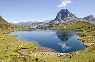
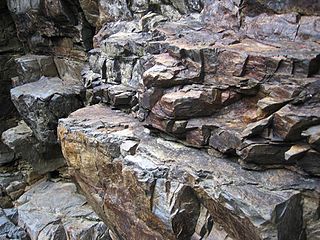
The Valbona Valley is in the Albanian Alps in northern Albania. It is part of Alps of Albania National Park, one of the most impressive and notable topographic features of Albania. Being the southernmost continuation of the Dinaric Alps, it forms a section of the Alpine-Himalayan orogenic belt, which extend from the Atlantic Ocean to the Himalaya Mountains. The mountains are characterized by limestone and dolomite rocks and shows major karst features. Maja Jezercë sprawls to the west of the valley and is the highest mountain of the Dinaric Alps, with an altitude of 2,694 m (8,839 ft). The Valbona River originate from several karst springs along the south of Maja Jezercë and the east of Valbona Pass. It is the largest river within the Albanian Alps and drains the entire eastern portion of the range. Over the past few million years, glaciers have at times covered most of the park. During the Würm period, the glacier of Valbona reached a total length of 9.5 kilometres. Nowadays, there are two very small active glaciers close to the northeastern edge of Maja Jezercë.

The Karaburun Peninsula is a peninsula of the Mediterranean Sea located in Southern and Southeastern Europe, which is almost completely surrounded by both the Adriatic Sea to the north and the Ionian Sea to the south. It is located in Southwestern Albania along the Albanian Ionian Sea Coast, whereas the Strait of Otranto separates it from Italy. The Strait of Mezokanal separates the peninsula from Sazan Island, while in the southeast stretches the Bay of Vlorë. Its name “Karaburun” derives from Turkish for "black cape". In classical antiquity, its name was the "Akrokeraunian Peninsula", whose name was derived from the eponymous Akrokeraunian mountains;this is because, in terms of geology, the Rrëza e Kanalit on the peninsula represent the continuation of said mountains, which are the highest and most extensive mountain range system that extends parallel to the Ionian Sea. Karaburun peninsula is sometimes called Ceraunian Peninsula due to the name of the mountain range. Created during the mesozoic era of the cretaceous and paleogene period, the crests of the mountain range form a northwest-southeast line with a series of distinct peaks along its irregular structure that are broken apart by steep and unequally slopes. The highest peaks are namely, the Maja Çaderës, Maja e Flamurit, Maja e Koretës and Maja e Ilqes.

Despite being a relatively small country, Albania is exceedingly rich in biodiversity. Its ecosystems and habitats support over 5,550 species of vascular and non-vascular plants and more than 15,600 species of coniferous and non-coniferous evergreens, most of which are threatened at global and European levels. The country has made recent efforts to expand its network of protected areas which now include: 11 national parks, 1 marine park, 718 nature monuments, 23 managed nature reserves, 11 protected landscapes, 4 World Heritage Sites, 4 Ramsar sites and other protected areas of various categories, that when combined, account for 21.36% of the territory. Furthermore, a biosphere reserve, 45 important plant areas and 16 important bird areas are found in the country.
The Central Mountain Region is a physiogeographical region encompassing the central and eastern edge of Albania. It comprises the mountainous inland extending all the way from the valley of Drin and the mountains of Sharr, Skanderbeg, Korab, and Shebenik-Jabllanicë, through the lakes of Ohrid and Prespa, until it reaches the village of Ersekë and the mountains of Pindus close to the border between the country and Greece.

For a small country, Albania is characterised by a considerable wealth of terrestrial and marine ecosystems and habitats with contrasting floral, faunal, and fungal species, defined in an area of 28,748 square kilometres. Most of the country is predominantly of Mediterranean character, comprehending the country's center and south, while the alpine affinity is more visible in the northeast.

Prespa National Park is a national park situated in southeastern Albania on the border triangle shared with Greece and North Macedonia. At approximately 277.5 km2 (107.1 sq mi), the park encompasses the country's sections of the Great and Small Prespa Lake. It is considerably characterised by high mountains, narrow islands, vast freshwater wetlands, salt marshes, meadows, reed beds and dense forests.
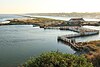
The Albanian Ionian Sea Coast is a coastline of the north-eastern Ionian Sea, that encompasses the south-western border of the Republic of Albania, stretching from the southern half of Karaburun Peninsula, across the historical region of Labëria, the city of Sarandë, the mountains of the Ceraunians, and the Albanian Riviera, to the Lake of Butrint, where the Strait of Corfu separates the country from Greece.