
Karst is a topography formed from the dissolution of soluble rocks such as limestone, dolomite, and gypsum. It is characterized by underground drainage systems with sinkholes and caves. It has also been documented for more weathering-resistant rocks, such as quartzite, given the right conditions. Subterranean drainage may limit surface water, with few to no rivers or lakes. However, in regions where the dissolved bedrock is covered or confined by one or more superimposed non-soluble rock strata, distinctive karst features may occur only at subsurface levels and can be totally missing above ground.

The Harz is a highland area in northern Germany. It has the highest elevations for that region, and its rugged terrain extends across parts of Lower Saxony, Saxony-Anhalt, and Thuringia. The name Harz derives from the Middle High German word Hardt or Hart. The name Hercynia derives from a Celtic name and could refer to other mountain forests, but has also been applied to the geology of the Harz. The Brocken is the highest summit in the Harz with an elevation of 1,141.1 metres (3,744 ft) above sea level. The Wurmberg is the highest peak located entirely within the state of Lower Saxony.

A sinkhole is a depression or hole in the ground caused by some form of collapse of the surface layer. The term is sometimes used to refer to doline, enclosed depressions that are locally also known as vrtače and shakeholes, and to openings where surface water enters into underground passages known as ponor, swallow hole or swallet. A cenote is a type of sinkhole that exposes groundwater underneath. Sink and stream sink are more general terms for sites that drain surface water, possibly by infiltration into sediment or crumbled rock.

The Riviera Maya is a tourism and resort district south of Cancun, Mexico. It straddles the coastal Federal Highway 307, along the Caribbean coastline of the state of Quintana Roo, located in the eastern portion of the Yucatán Peninsula. Historically, this district started at the city of Playa del Carmen and ended at the village of Tulum, although the towns of Puerto Morelos, situated to the north of Playa del Carmen, as well as the town of Felipe Carrillo Puerto, situated 40 km (25 mi) to the south of Tulum, are both currently being promoted as part of the Riviera Maya tourist corridor.

A cenote is a natural pit, or sinkhole, resulting from the collapse of limestone bedrock that exposes groundwater. The regional term is specifically associated with the Yucatán Peninsula of Mexico, where cenotes were commonly used for water supplies by the ancient Maya, and occasionally for sacrificial offerings. The term derives from a word used by the lowland Yucatec Maya—tsʼonoʼot—to refer to any location with accessible groundwater.
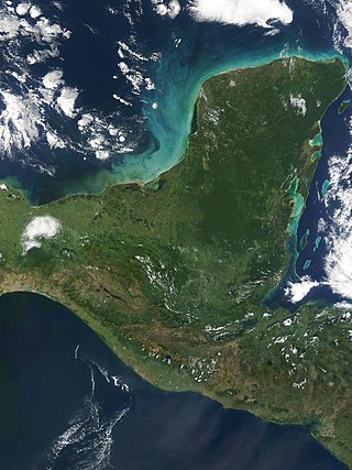
The Yucatán Peninsula is a large peninsula in southeast Mexico and adjacent portions of Belize and Guatemala. The peninsula extends towards the northeast, separating the Gulf of Mexico to the north and west of the peninsula from the Caribbean Sea to the east. The Yucatán Channel, between the northeastern corner of the peninsula and Cuba, connects the two bodies of water.

Melissani Cave or Melissani Lake, also Melisani is a cave located on the island of Kefalonia, northwest of Sami, about 5 km (3.1 mi) Southeast of Agia Effimia, Northeast of Argostoli and Northwest of Poros. The Ionian Sea lies to the east with the Strait of Ithaca. Forests surround the cave and the mountain slope is to the west. Near the cave is the entry to the cave with parking lots and is passed almost in the middle of the main road linking Sami and Agia Efimia especially to the northern part of the island. Some say the water is so clear the boats look like they are floating on air.

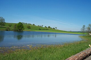
A turlough, is a seasonal or periodic water body found mostly in limestone karst areas of Ireland, west of the River Shannon. The name comes from the Irish tur, meaning "dry", and loch, meaning "lake". The water bodies fill and empty with the changes in the level of the water table, usually being very low or empty during summer and autumn and full in the winter. As groundwater levels drop the water drains away underground through cracks in the karstic limestone.

Dzibilchaltún is a Maya archaeological site in the Mexican state of Yucatán, approximately 10 miles (16 km) north of state capital of Mérida.

Dos Ojos is part of a flooded cave system located north of Tulum, on the Caribbean coast of the Yucatán Peninsula, in the state of Quintana Roo, Mexico. The exploration of Dos Ojos began in 1987 and still continues. The surveyed extent of the cave system is 82 kilometers (51 mi) and there are 28 known sinkhole entrances, which are locally called cenotes. In January 2018, a connection was found between Sistema Dos Ojos and Sistema Sac Actun. The smaller Dos Ojos became a part of Sac Actun, making the Sistema Sac Actun the longest known underwater cave system in the world.

Zacatón is a cenote belonging to the Zacatón system - a group of unusual karst features located in Aldama Municipality near the Sierra de Tamaulipas in the northeastern state of Tamaulipas, Mexico. It is the deepest known water-filled sinkhole in the world with a total depth of 339 meters (1,112 ft). The 392 meters (1,286 ft) deep Pozzo del Merro is deeper, but its nature as a near-vertical cave or a sinkhole still being debated.

Chichén Itzá was a large pre-Columbian city built by the Maya people of the Terminal Classic period. The archeological site is located in Tinúm Municipality, Yucatán State, Mexico.

A karst spring or karstic spring is a spring that is part of a karst hydrological system.

The South Harz Nature Park is located in the county of Nordhausen in north Thuringia, Germany. The act designating this nature park in the Harz Mountains came into force on 31 December 2010 and thus founded the fifth nature park in Thuringia. It has an area of 267 km². The park is managed by the South Harz Tourist Association in conjunction with the Kyffhäuser Nature Park.
Little Blue Lake is a water-filled doline in the Australian state of South Australia located in the state's south-east in the locality of Mount Schank about 20 kilometres (12 mi) south of the municipal seat of Mount Gambier. It is notable locally as a swimming hole and nationally as a cave diving site. It is managed by the District Council of Grant and has been developed as a recreational and tourism venue.
The Eichener See, known in the Alemannic dialect as the Eiemer See, near Eichen in the Baden-Württemberg county of Lörrach is a periodic (astatic) karst lake in the Southern Black Forest in Germany.

Cave diving is underwater diving in water-filled caves. The equipment used varies depending on the circumstances, and ranges from breath hold to surface supplied, but almost all cave diving is done using scuba equipment, often in specialised configurations with redundancies such as sidemount or backmounted twinset. Recreational cave diving is generally considered to be a type of technical diving due to the lack of a free surface during large parts of the dive, and often involves planned decompression stops. A distinction is made by recreational diver training agencies between cave diving and cavern diving, where cavern diving is deemed to be diving in those parts of a cave where the exit to open water can be seen by natural light. An arbitrary distance limit to the open water surface may also be specified. Despite the risks, water-filled caves attract scuba divers, cavers, and speleologists due to their often unexplored nature, and present divers with a technical diving challenge.
An anchialine system is a landlocked body of water with a subterranean connection to the ocean. Depending on its formation, these systems can exist in one of two primary forms: pools or caves. The primary differentiating characteristics between pools and caves is the availability of light; cave systems are generally aphotic while pools are euphotic. The difference in light availability has a large influence on the biology of a given system. Anchialine systems are a feature of coastal aquifers which are density stratified, with water near the surface being fresh or brackish, and saline water intruding from the coast at depth. Depending on the site, it is sometimes possible to access the deeper saline water directly in the anchialine pool, or sometimes it may be accessible by cave diving.


