List of lakes
The list of lakes of Serbia, excluding the territory of Kosovo.
| Lake | Max. area (km2) | Alt. (m) | Depth (m) | Type | Characteristics | Photo |
|---|---|---|---|---|---|---|
| Đerdap [2] [3] [4] [5] | 253 | 70 | 92 | artificial | hydroelectric reservoir (Danube) Shared with Romania |  |
| Đerdap II [3] | 92 | artificial | hydroelectric reservoir (Danube) Shared with Romania | 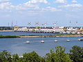 | ||
| Vlasina Lake [2] [4] [5] | 16 | 1,213 | 22 | semi-artificial | peat bog turned into reservoir (Vlasina River) |  |
| Ečka fish pond [6] | 15.4 | 1.3 | artificial | fish pond |  | |
| Perućac Lake [2] [4] [5] | 12.4 | 290 | 70 | artificial | hydroelectric reservoir (Drina), also called Bajina Bašta Shared with Bosnia & Herzegovina |  |
| Gazivoda Lake [2] [4] | 11.9 | 693 | 105 | artificial | industrial reservoir (Ibar) |  |
| Zasavica [4] | 11.5 | 10 | natural | bog, ancient arm of the Sava |  | |
| Carska bara [4] | 11 | natural | bog |  | ||
| Fish pond Sakule [7] | 10.05 | 81 | artificial | fish pond | ||
| Gruža Lake [4] | 9.19 | artificial | industrial reservoir (Gruža (river)), Sea of Šumadija | 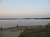 | ||
| Zvornik Lake [2] [4] [5] | 8.1 | 140 | 28 | artificial | hydroelectric reservoir (Drina) Shared with Bosnia & Herzegovina |  |
| Zlatar Lake [2] [4] [5] | 7.3 | 880 | 75 | artificial | hydroelectric reservoir (Uvac) |  |
| Potpeć Lake [2] [8] | 7 | 436 | 40 | artificial | hydroelectric reservoir (Lim) | |
| Obedska bara [4] [5] | 7 | 72 | 12 | natural | bog, ancient arm of Sava | 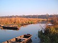 |
| Veliki Rit | 7 | artificial | fish pond | |||
| Kapetanski Rit | 6.13 | artificial | fish pond | |||
| Sjenica Lake | 5 | 985 | 35 | artificial | hydroelectric reservoir (Uvac) |  |
| Bečej Fish pond | 5.7 | artificial | fish pond | |||
| Palić Lake [2] [4] [5] | 5.6 | 101 | 3.5 | (semi-)natural | eolian lake, artificially preserved | |
| Zavoj Lake [4] [9] | 5.53 | 612 | 60 | artificial | originally created by landslide, turned into hydroelectrical reservoir (Visočica) | 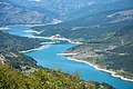 |
| Koviljski rit | 5.5 | natural | marsh |  | ||
| Fish pond Uzdin | 5.5 | artificial | fish pond | |||
| Bovan Lake | 5 | 7 | artificial | industrial reservoir (Sokobanjska Moravica) |  | |
| White Lake [2] [4] [5] | 4.8 | 75 | 2.5 | natural | turned into fish pond | |
| Lake Ćelije [4] | 3.35 | 277 | 41 | artificial | water supply (Rasina) |  |
| Silver Lake | 4 | 70 | 8 | natural | dammed arm of the Danube |  |
| Zlatica | 3.9 | artificial | fish pond, formerly Jazovo | |||
| Opolje Lake [4] [5] | 3.7 | 980 | semi-artificial | originally karst lake, turned into industrial reservoir | ||
| Ludaš Lake [4] [10] | 3.68 | 101 | 2.5 | natural | eolian lake, also Ludoš |  |
| Fish pond Jedinstvo | 3.5 | artificial | fish pond | |||
| Okanj | 3 | natural | bog | |||
| Garaši | 3 | 411 | 40 | artificial | industrial reservoir | |
| Novi Kneževac fish pond | 2.63 | artificial | fish pond | |||
| Velebit fish pond | 2.58 | artificial | fish pond | |||
| Zobnatica Lake | 2.55 | artificial | industrial reservoir (Krivaja) | |||
| Futog fish pond | 2.1 | artificial | fish pond, formerly DTD | |||
| Veliko Blato | 2 | natural | bog, within Pančevački Rit |  | ||
| Gračanica Lake [4] | 2 | 29 | artificial | industrial reservoir (Gračanka) |  | |
| Rovni Lake | 3.2 | artificial | industrial reservoir (Jablanica) |  | ||
| Sutjeska fish pond | 2 | artificial | fish pond | |||
| Susek fish pond | 2 | artificial | fish pond | |||
| Kolut fish pond | 1.82 | artificial | fish pond | |||
| Lake Međuvršje | 1.5 | 273 | 23 | artificial | hydroelectrical reservoir (West Morava) |  |
| Bela Crkva lakes [11] [12] | 1.5 | 89 | artificial | six lakes in close proximity, former gravel exploitation sites |  | |
| Veliko Kopovo | 1.45 | natural | bog | |||
| Srpski Miletić fish pond | 1.14 | artificial | fish pond | |||
| Rusanda [4] [5] | 1.1 | 82 | 1.5 | natural | mud lake | |
| Krajkovac Lake [13] | 1 | 450 | artificial | reservoir, near Krajkovac, Merošina | ||
| Jegrička | 0.98 | artificial | fish pond |  | ||
| Sava Lake [5] | 0.8 | natural | dammed arm of Sava, see also Ada Ciganlija |  | ||
| Paljuvi | 0.8 | artificial | industrial reservoir (Klanica) | |||
| Pavlovci Lake | 0.8 | artificial | industrial reservoir, also Kudoš | |||
| Borkovac Lake | 0.69 | 6 | artificial | industrial reservoir (Borkovac) |  | |
| Moharač Lake [14] | 0.6 | artificial | reservoir | |||
| Ribnica Lake [15] [16] | 0.4 | 968 | artificial | industrial-recreational reservoir (Crni Rzav) |  | |
| Ada Safari | 0.04 | artificial | fishing resort |  | ||
| Grza Lake | ||||||
| Radoinja Lake [15] | 0.55 | 30 | Hydroelectric reservoir (Uvac river) |  | ||
| Bor Lake [17] | 0.3 | 438 | 50 | reservoir |  | |
| Markovac Lake | 0.3 | artificial |  | |||
| Semeteš Lake |  | |||||
| Oblačina Lake | 0.28 | 280 | natural | Natural lake near Oblačina, Merošina |  | |
| Očaga | 0.12 | artificial |  | |||
| Pariguz | 0.12 | reservoir | ||||
| Taložnik | 0.12 | artificial | auxiliary to Sava Lake, see Ada Ciganlija | |||
| Aleksandrovac Lake [18] | 0.08 | artificial, part of irrigation system of South Morava near Vranje | ||||
| Duboki potok [19] | 0.07 | artificial | reservoir on eponymous creek near Barajevo | |||
| Goli Kamen | 0.05 | 550 | artificial | reservoir near Vučkovica, Guča | ||
| Dulene Lake | 0.03 | 435 | 7 | artificial | Abandoned water reservoir near Dulene, Kragujevac | |
| Bela Reka | 0.02 | artificial |  | |||
| Rabrovac Lake | 0.01 | |||||
| Ostojićevo fish pond | fish pond | |||||
| Celeruša [20] | natural | oxbow lake, old meander of Tisa River near Čoka | ||||
| Trešnja | 0.003 | artificial |  | |||
| Rakina bara [21] | 0.002 | 2 | natural | Karst sinkhole near Sremčica, Belgrade | ||
| Bešenovo Lake (White Stone) [22] | 57 | artificial | Submerged quarry near Bešenovo |  | ||
| Jarevac lake | artificial |  |
- Note: in Serbian, the word for lake (jezero) is almost always a part of the lake's name. If the name is given as a noun, jezero precedes it (Jezero Gazivode), if the name is given as an adjective (usually with the -ko suffix), jezero follows it (Vlasinsko jezero).