List of lakes of Kazakhstan

Last updated

Excluding the northernmost districts, Kazakhstan consists of endorheic basins, where rivers flow into one of the numerous lakes. The most important drainage system is known as Yedisu, meaning "seven rivers" in Turkic languages. Below is the list of the more important lakes, some of which are shared (Caspian Sea, Lake Aral, Lake Aike, etc.) with the neighbouring countries.

Lake nameSurface area Region Notes
Caspian Sea 371,000 square kilometres (143,244 sq mi) Atyrau Region, Mangystau Region The Caspian Sea is the world's largest enclosed body of water.
Alakol 2,650 square kilometres (1,023 sq mi) Almaty Region Bird breeding and nesting ground
Aral 17,160 square kilometres (6,626 sq mi)Shrinking owing to environmental problems [1]
Aralsor 200 square kilometres (77 sq mi) West Kazakhstan Region Pink lake
Ashchykol 74 square kilometres (29 sq mi) Kyzylorda Region / Turkistan Region Main lake of the Ashchykol Depression
Ayke 64.7 square kilometres (25 sq mi) Aktobe Region
Azhibeksor SW of Lake Tengiz [2]
Balkhash 16,996 square kilometres (6,562 sq mi) Almaty Region, Karagandy Region, Jambyl Region
Bartogay Almaty Region Reservoir on the Chilik River
Bolshoy Azhbulat Pavlodar Region
Chagan Artificial lake (Former nuclear test site)
Issyk 0.22 square kilometres (0 sq mi) Almaty Region Not to be confused with Issyk Kul Lake in Kyrgyzstan
Jasybay 4 square kilometres (2 sq mi) Pavlodar Region One of the lakes of the Bayanaul Range
Kayindi Almaty Region
Kamyslybas 176 square kilometres (68 sq mi)
Kapchagay also spelled Qapshaghay Bogeni Reservoir
Kopa 14 square kilometres (5 sq mi) Akmola Region
Markakol 455 square kilometres (176 sq mi)
Sasykkol 600 square kilometres (232 sq mi) Almaty Region Surface can reach 736 square kilometres (284 sq mi)
Shalkarteniz 1,800 square kilometres (695 sq mi) Aktobe Region
Tengiz 1,382 square kilometres (534 sq mi) Akmola Region Bird breeding and nesting ground
Toraigyr 0.88 square kilometres (0 sq mi) Pavlodar Region One of the lakes of the Bayanaul Range
Tuzkol 13.5 square kilometres (5 sq mi) Pavlodar Region Salt lake in Bayanaul District
Ulken-Karoy 305 square kilometres (118 sq mi) North Kazakhstan Region
Zaysan 1,810 square kilometres (699 sq mi)
Zerenda 11.9 square kilometres (5 sq mi) Akmola Region
Zhaksykylysh 74.5 square kilometres (29 sq mi) Kyzylorda Region Table salt mining site
Zhasylkol 1 square kilometre (0 sq mi) Almaty Region

See also

Related Research Articles

<span class="mw-page-title-main">Irtysh</span> River in China, Kazakhstan and Russia

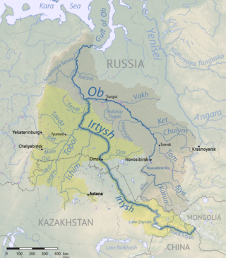
The Irtysh is a river in Russia, China, and Kazakhstan. It is the chief tributary of the Ob and is also the second longest tributary river in the world after Paraná River.

<span class="mw-page-title-main">Ural (river)</span> Major river in Russia and Kazakhstan

The Ural, known before 1775 as Yaik, is a river flowing through Russia and Kazakhstan in the continental border between Europe and Asia. It originates in the southern Ural Mountains and discharges into the Caspian Sea. At 2,428 kilometres (1,509 mi), it is the third-longest river in Europe after the Volga and the Danube, and the 18th-longest river in Asia. The Ural is conventionally considered part of the boundary between the continents of Europe and Asia.

<span class="mw-page-title-main">Lake Balkhash</span> Lake in southeastern Kazakhstan

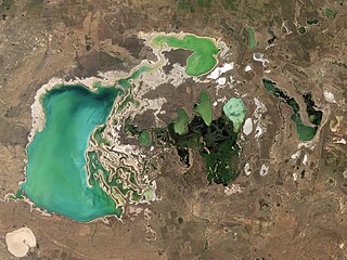
Lake Balkhash is a lake in southeastern Kazakhstan, one of the largest lakes in Asia and the 15th largest in the world. It is located in the eastern part of Central Asia and sits in the Balkhash-Alakol Basin, an endorheic (closed) basin. The basin drains seven rivers, the primary of which is the Ili, bringing most of the riparian inflow; others, such as the Karatal, bring surface and subsurface flow. The Ili is fed by precipitation, largely vernal snowmelt, from the mountains of China's Xinjiang region.

<span class="mw-page-title-main">Ili (river)</span> River in Central Asia, through northwest China and southeast Kazakhstan

The Ili is a river situated in Northwest China and Southeastern Kazakhstan. It flows from the Ili Kazakh Autonomous Prefecture of the Xinjiang Uighur Autonomous Region to the Almaty Region in Kazakhstan.

<span class="mw-page-title-main">Chu (river)</span> River in Kyrgyzstan and Kazakhstan

The Chu is a river in Northern Kyrgyzstan and Southern Kazakhstan. Of its total length of 1,067 kilometres (663 mi), the first 115 kilometres are in Kyrgyzstan, then for 221 kilometres the river is the border between Kyrgyzstan and Kazakhstan and the last 731 kilometres are in Kazakhstan. It is one of the longest rivers in Kyrgyzstan and in Kazakhstan. It has a drainage basin of 62,500 square kilometres (24,100 sq mi).

<span class="mw-page-title-main">Zhetysu</span> Historical region of southeast Kazakhstan

Zhetysu, or Jeti-Suu, is a historical name of a part of Central Asia corresponding to the southeastern part of modern Kazakhstan. It owes its name, meaning "seven rivers" in Kazakh, to the rivers that flow from the southeast into Lake Balkhash. Zhetysu falls into today's Almaty Region and other South-Eastern parts of Kazakhstan and some parts of Northern Kyrgyzstan.

<span class="mw-page-title-main">Lake Tengiz</span> Body of water

Tengiz Lake is a saline lake in Korgalzhyn District, Akmola Region, Kazakhstan.

<span class="mw-page-title-main">Shalkar (lake)</span> Body of water

Shalkar is a brackish lake in Terekti District, West Kazakhstan Region, Kazakhstan.

<span class="mw-page-title-main">Lakes of the lower Turgay and Irgiz</span> Protected lakes in Kazakhstan

Lakes of the lower Turgay and Irgiz is a protected area in the Turgay Depression, Kazakhstan. Administratively it is located in the Yrgyz District of the Aktobe Region.

<span class="mw-page-title-main">Shaglyteniz</span> Lake in Kazakhstan

Shaglyteniz or Shagalalyteniz is a lake in Akkayin and Taiynsha districts, North Kazakhstan Region, Kazakhstan.

<span class="mw-page-title-main">Teniz</span> Lake in Kazakhstan

Teniz is a lake in Kamysty District, Kostanay Region, Kazakhstan.

<span class="mw-page-title-main">Urzhar (river)</span> River in Kazakhstan

The Urzhar is a river in the Abai Region, Kazakhstan. It has a length of 206 km (128 mi) and a drainage basin of 5,280 km2 (2,040 sq mi).

<span class="mw-page-title-main">Sorbulak</span> Body of water

Sorbulak is a lake in Ile District, Almaty Region, Kazakhstan.

<span class="mw-page-title-main">Saumalkol</span> Body of water

Saumalkol is a salt lake in Karkaraly District, Karaganda Region, Kazakhstan.

<span class="mw-page-title-main">Kulanotpes</span> River in Kazakhstan

The Kulanotpes is a river in the Nura District, Karaganda Region, Kazakhstan. It has a length of 364 km (226 mi) and a drainage basin of 25,900 km2 (10,000 sq mi).

<span class="mw-page-title-main">Kyzylkol</span> Lake in Kazakhstan

Kyzylkol is a lake in Sozak District, Turkestan Region, Kazakhstan.

<span class="mw-page-title-main">Akzhar</span> Lake group in Kazakhstan

Akzhar is a salt lake group in the Zhambyl and Turkistan regions, Kazakhstan.

<span class="mw-page-title-main">Telikol</span> Lake in Kazakhstan

Telikol is a lake in the Kyzylorda Region, Kazakhstan.

<span class="mw-page-title-main">Tuzkol, Raiymbek District</span> Body of water

Tuzkol is a high-altitude salt lake in Raiymbek District, Almaty Region, Kazakhstan.

<span class="mw-page-title-main">Teniz, Mendykara District</span> Body of water

Teniz is a lake in Mendykara District, Kostanay Region, Kazakhstan.

References

  1. Kazakhstan government is trying to rescue the northern part of the lake
  2. "Äzhibeksor Köli". Mapcarta. Retrieved 25 May 2017.