
Lake Toba is a large natural lake in North Sumatra, Indonesia, occupying the caldera of the Toba supervolcano. The lake is located in the middle of the northern part of the island of Sumatra, with a surface elevation of about 900 metres (2,953 ft), the lake stretches from 2.88°N 98.52°E to 2.35°N 99.1°E. The lake is about 100 kilometres long, 30 kilometres (19 mi) wide, and up to 505 metres (1,657 ft) deep. It is the largest lake in Indonesia and the largest volcanic lake in the world. Toba Caldera is one of twenty geoparks in Indonesia, and was recognised in July 2020 as one of the UNESCO Global Geoparks.
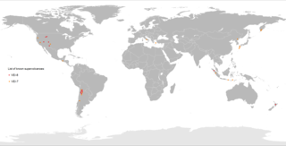
A supervolcano is a volcano that has had an eruption with a volcanic explosivity index (VEI) of 8, the largest recorded value on the index. This means the volume of deposits for such an eruption is greater than 1,000 cubic kilometers.

Sulawesi, also known as Celebes, is an island in Indonesia. One of the four Greater Sunda Islands, and the world's 11th-largest island, it is situated east of Borneo, west of the Maluku Islands, and south of Mindanao and the Sulu Archipelago. Within Indonesia, only Sumatra, Borneo, and Papua are larger in territory, and only Java and Sumatra are more populous.
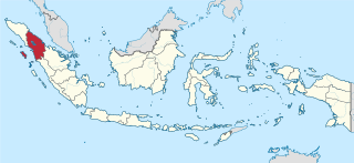
North Sumatra, also called North Sumatra Province, is a province of Indonesia located in the northern part of the island of Sumatra, just south of Aceh. Its capital and largest city is Medan on the east coast of the island. It is bordered by Aceh on the northwest and Riau and West Sumatra on the southeast, by coastlines located on the Indian Ocean to the west, and by the Strait of Malacca to the east.

Samosir, or Samosir Island, is a large volcanic island in Lake Toba, located in North Sumatra Province on the island of Sumatra in Indonesia. Administratively, Samosir Island is governed as six of the nine districts within Samosir Regency. The lake and island were formed after the eruption of the Toba supervolcano some 75,000 years ago.

The Bukit Barisan or the Barisan Mountains are a mountain range on the western side of Sumatra, Indonesia, covering nearly 1,700 km (1,050 mi) from the north to the south of the island. The Bukit Barisan range consists primarily of volcanoes shrouded in dense jungle cover, including Sumatran tropical pine forests on the higher slopes. The highest peak of the range is Mount Kerinci at 3,800 metres (12,467 ft). The Bukit Barisan Selatan National Park is situated towards the southern end of the range in Liwa, Indonesia.

Soroako, also spelled Sorowako, is a small mining town in the north-east of South Sulawesi province, in the centre of Sulawesi island in Indonesia. It is the location of the Sorowako Mine, which is the largest open-pit mine in Indonesia, owned by PT Vale Indonesia, a subsidiary of the Canadian based mining company Vale Inco.

Lake Towuti is a lake in East Luwu Regency, South Sulawesi province, Indonesia. Surrounded by mountains, it is the largest lake of the island of Sulawesi and one of the five lakes of the Malili Lake system. The Larona River flows from the lake to the Boni Bay. The town Laronda is located on its shore.
Lake Matano, also known as Matana, is a tropical lake in East Luwu Regency, South Sulawesi province, Indonesia, that is noteworthy for the unique environment in its deeper layers.
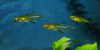
The Telmatherininae, the sail-fin silversides are a subfamily of atheriniform fish from the rainbowfish family, the Melanotaeniidae, inhabiting fresh and brackish water. All but the species Kalyptatherina helodes are restricted to the Indonesian island of Sulawesi, and most are found solely in the Malili Lake system, consisting of Matano and Towuti, and the small Lontoa (Wawantoa), Mahalona and Masapi.

A lake island is any landmass within a lake. It is a type of inland island. Lake islands may form a lake archipelago.

The following outline is provided as an overview of and topical guide to Indonesia:

Indonesia was the fourth-largest producer of coffee in the world in 2014. Coffee cultivation in Indonesia began in the late 1600s and early 1700s, in the early Dutch colonial period, and has played an important part in the growth of the country. Indonesia is geographically and climatologically well-suited for coffee plantations, near the equator and with numerous interior mountainous regions on its main islands, creating well-suited microclimates for the growth and production of coffee.

Caridina dennerli is a small species of freshwater shrimp from Sulawesi (Indonesia) that grows up to 2.5 centimetres (1.0 in) in length. It takes its name from the German company Dennerle, which supported the expedition that led to the scientific description of the species. It is popularly known as the cardinal shrimp or Sulawesi shrimp in the aquarium trade.

The Greater Sunda Islands are four tropical islands situated within the Indonesian Archipelago, in the Pacific Ocean. The islands, Borneo, Java, Sulawesi and Sumatra, are internationally recognised for their ecological diversity and rich culture. Together with the Lesser Sunda Islands to their southeast, they comprise the archipelago known as the Sunda Islands.
