American Samoa is made up of five main volcanic islands and two coral atolls. [1] American Samoa has a limited supply of drinking water. [2]
American Samoa is made up of five main volcanic islands and two coral atolls. [1] American Samoa has a limited supply of drinking water. [2]
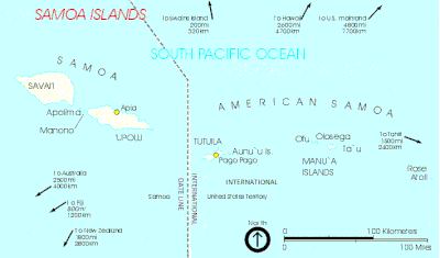
Pago Pago is the capital of American Samoa. It is in Maoputasi County on Tutuila, which is American Samoa's main island.

The Samoan Islands are an archipelago covering 3,030 km2 (1,170 sq mi) in the central South Pacific, forming part of Polynesia and of the wider region of Oceania. Administratively, the archipelago comprises all of the Independent State of Samoa and most of American Samoa. The land masses of the two Samoan jurisdictions are separated by 64 km (40 mi) of ocean at their closest points.

Fagatogo is the downtown area of Pago Pago. Located in the low grounds at the foot of Matafao Peak, it was the location of the first American settlement on Tutuila Island. It includes the sub-village of Malaloa. Today, Fagatogo is the government, commercial, financial, and shipping center of Tutuila. It is also the administrative capital of American Samoa. It is the location of the American Samoa Fono (legislature), and is listed in the Constitution of American Samoa as the territory's official seat of government. Its population is 1,737.
Utulei or ʻUtulei is a village in Maoputasi County, in the Eastern District of Tutuila, the main island of American Samoa. Utulei is traditionally considered to be a section of Fagatogo village, the legislative capital of American Samoa, and is located on the southwest edge of Pago Pago Harbor. Utulei is the site of many local landmarks: The A. P. Lutali Executive Office Building, which is next to the Feleti Barstow Library; paved roads that wind up to a former cablecar terminal on Solo Hill; the governor's mansion, which sits on Mauga o Alii, overlooking the entrance to Goat's Island, and the lieutenant governor's residence directly downhill from it; the Lee Auditorium, built in 1962; American Samoa's television studios, known as the Michael J. Kirwan Educational Television Center; and the Rainmaker Hotel. Utulei Terminal offers views of Rainmaker Mountain.

Aunuʻu is a small volcanic island off the southeastern shore of Tutuila in Saʻole County, American Samoa. It has a land area of 374.83 acres, and a 2010 census population of 436 persons. Politically, it is a part of the Eastern District, one of the two primary political divisions of American Samoa.

Leone is the second-largest city on Tutuila Island's west coast. The village is on the south-west coast of Tutuila Island, American Samoa. Leone was the ancient capital of Tutuila Island. Leone was also where the Samoan Islands’ first missionary, John Williams, visited on October 18, 1832. A monument in honor of Williams has been erected in front of Zion Church. Its large church was the first to be built in American Samoa. It has three towers, a carved ceiling and stained glass. Until steamships were invented, Leone was the preferred anchorage of sailing ships which did not risk entering Pago Pago Harbor. Much early contact between Samoans and Europeans took place in Leone.
Nuʻuuli is a village on the central east coast of Tutuila Island, American Samoa. It is located on a peninsula several miles up from Pago Pago International Airport. Nuʻuuli is located between Pago Pago International Airport and Coconut Point. It is a shopping district which is home to stores, groceries and many more shops.

Tafuna is a village in Tualauta County, Western District, American Samoa. It is the most populous village in American Samoa, with a population of 7,988 according to the 2020 U.S. Census, and is the center of nightlife on island.

Return to Paradise is an American South Seas adventure drama film released by United Artists in 1953. The film was directed by Mark Robson and starred Gary Cooper, Barry Jones and Roberta Haynes. It was based on a short story, "Mr. Morgan", by James Michener in his 1951 short story collection Return to Paradise, his sequel to his 1947 novel Tales of the South Pacific. It was filmed on location in Matautu, Lefaga Western Samoa.

American Samoa is an unincorporated territory of the United States located in the South Pacific Ocean, southeast of the island country of Samoa. Centered on 14.3°S 170.7°W, it is east of the International Date Line and the Wallis and Futuna Islands, west of the Cook Islands, north of Tonga, and some 500 kilometers (310 mi) south of Tokelau. American Samoa is the southernmost territory of the United States and one of two U.S. territories south of the Equator, along with the uninhabited Jarvis Island.

Alega is a village on the southeast coast of Tutuila Island, American Samoa. One of the island's least populous villages, it is located to the east of Pago Pago Harbor and to the west of Faga'itua Bay.

Pélé Island, sometimes spelled Pele in English, is a volcanic island located 11,2 miles north of the island of Éfaté in the Shefa Province of the Republic of Vanuatu. It has a total area of 1.7 square miles, Pélé is inhabited by about 200-220 Ni-Vanuatu villagers residing in the four villages: Worsiviu, Worearu, Piliura, and Launamoa. Pélé Island is a part of the MPA Nguna-Pele Marine Protected Area, which was established in 2003, and is a popular Vanuatuan diving location. The Nguna-Pele Marine Protected Area covers a total area of 11.5 sq. mi., including numerous reefs, sea grass beds, mangrove forests and intertidal lagoons. The Nguna-Pele Marine Protection Agency is located in the village of Piliura, and mounts an exhibition and sells T-shirts. Income from tourism is distributed by the Village Tourism Committee and supports aims as village water supply projects. The island can be visited daily by boat from the Paonangisu area by the town of Emua on Éfaté's north coast. There are also yachts available both from Emua and Nguna for day and overnight charters to the island. The island is nearly adjacent to the island of Nguna, with a small passage no deeper than 33 yards separating the two. It has a tropical climate and has a maximum elevation of 650 feet at its highest. Much of the island is extremely steep and rocks prevent you from walking along the coastline around the island. White sandy beaches are found in Piliura, Worearu, Laonamoa, and Sake. Overpopulation has led to a steady migration from Pele villages to southern Nguna in recent times.
Tula is a village in the Eastern District of Tutuila Island in American Samoa. Tula is located in Vaifanua County and had a population of 405 as of the 2010 U.S. Census.
Fagasā is a village in the Eastern District of Tutuila Island in American Samoa. The village lies by Fagasa Bay, on the north shore of the island. Its name is Samoan and translates to "Forbidden Bay." The village borders the Tutuila-section of National Park of American Samoa. The trailhead to Mount ʻAlava is located near the village by Fagasa Pass.
Feleti Barstow Public Library is the main library in American Samoa, and is located in the village of Utulei in Maoputasi County. It is the central public library for the territory and is situated immediately across from the Office of Tourism, next to the Executive Office Building, and just behind Samoana High School. Besides a permanent display depicting American Samoa’s involvement in the Apollo Space Program, the library has also worked with the American Samoa Historic Preservation Office (ASHPO) since 2000 at creating a historic Polynesian Photo Archive. The goal of the project has been to electronically catalog and archive around 6,000 still and moving images of Polynesia which were collected by the American Samoa Government. The library has an extensive Pacific Collection which houses articles, books, and reports relevant to Pacific- and Samoan history. A large collection of photographs are stored in its Polynesian Photo Archive, which is a subset of their Pacific Collection.
Ottoville is a subdivision or district within the village of Tafuna, American Samoa.
Amalau is the name of a valley and a bay within the National Park of American Samoa. Amalau Valley is located between Vatia and Afono, and it is an isolated valley with various wildlife such as large numbers of native bird species and flying fox megabats. Amalau Valley is reached on the road leading to Vatia. There are only a few homes at Amalau.
Pala Lagoon is an indentation in the south coast of Tutuila Island in American Samoa. The villages of Nuʻuuli and Tafuna are located on its shore. Pala Lagoon is approximately one mile across and has a surface area of around 75 square miles (190 km2) The lagoon's depth varies from 1 foot (0.30 m)-5 feet (1.5 m) depending on the tide. The deepest areas of the lagoon were dredged when the Tafuna Airport runway was built in the 1960s. The entrance to the lagoon is about 1,200 feet (370 m) wide with a shallow reef top 1 foot (0.30 m)-3 feet (0.91 m) in depth. Along the northern and eastern shores, a 90-acre (36 ha) forest is located with red and oriental mangroves. The lagoon's northern shore has various streams which discharge into Pala Lagoon. The largest streams are Papa and Vaitele. There is a public recreation area known as Lions Park on the western edge of the lagoon, in the village of Tafuna. Pala Lagoon is also utilized for fishing and crabbing on a daily basis. It is a very important nursery and spawning ground for many fish and invertebrates found on the reef.
Tia Seu Lupe is a historical site at Fatuoaiga, American Samoa, which is maintained by the American Samoa Department of Parks and Recreation. The Tia Seu Lupe Historic Monument was dedicated by Governor Peter Tali Coleman in May 1990. It is located on a 0.2 ha plot of land on the Tafuna Plain which has been leased by the Government of American Samoa. The monument exhibits a stone structure which archeologists believe were platforms constructed for the chiefly sport of pigeon catching. The name "Tia Seu Lupe" literally means "earthen mound to catch pigeons".
Sven V. Ortquist was a Samoan artist, wood-carver, and sculptor. Besides a carver, he was a boat builder, book illustrator, and painter. He has been awarded the Consortium for Pacific Arts and Cultures’ Heritage Award and the Governor’s Award for Excellence in the Arts. He has been the Master Carver for the American Samoa Council on Arts, Culture and the Humanities. He has also been the resident artist at Jean P. Haydon Museum. Ortquist was the founder and first president of the Samoan Voyaging Society, Aiga Tautai o Samoa. Ortquist has been an artist-in-residence at the territory’s largest college, American Samoa Community College and has also worked with a United Nations program teaching and constructing cheap plywood fishing boats for the poor.