List of lakes of South Carolina

Last updated

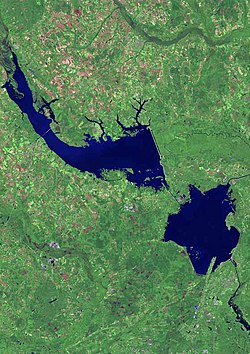
Lake Marion (top) and Lake Moultrie (bottom right) from space Lake marion moultrie map.jpg
Lake Marion (top) and Lake Moultrie (bottom right) from space

This is a list of lakes and reservoirs in the state of South Carolina in the United States. All major lakes in South Carolina are man-made. Swimming, fishing, and/or boating are permitted in some of these lakes, but not all.

Contents

Lakes in South Carolina

Lake Jocassee from the Bad Creek entrance to the lake Lake-Jocassee-from-Outpost.jpg
Lake Jocassee from the Bad Creek entrance to the lake
The Richard B. Russell Dam at Richard B. Russell Lake USACE Richard B Russell Dam and Lake.jpg
The Richard B. Russell Dam at Richard B. Russell Lake

See also

Related Research Articles

<span class="mw-page-title-main">Alamance County, North Carolina</span> County in North Carolina, United States

Alamance County is a county in North Carolina. As of the 2020 census, the population was 171,415. Its county seat is Graham. Formed in 1849 from Orange County to the east, Alamance County has been the site of significant historical events, textile manufacturing, and agriculture.

Lake Secession is a census-designated place (CDP) in Abbeville County, South Carolina located near a lake by the same name. The population was 1,083 at the 2010 census.

<span class="mw-page-title-main">Lake Strom Thurmond</span> Man-made lake in Georgia and South Carolina, United States

Lake Strom Thurmond, officially designated J. Strom Thurmond Reservoir at the federal level, and Clarks Hill Lake by the state of Georgia, is a man-made reservoir at the border between Georgia and South Carolina in the Savannah River Basin.

<span class="mw-page-title-main">Yadkin River</span> River in North Carolina, United States

The Yadkin River is one of the longest rivers in the US state of North Carolina, flowing 215 miles (346 km). It rises in the northwestern portion of the state near the Blue Ridge Parkway's Thunder Hill Overlook. Several parts of the river are impounded by dams for water, power, and flood control. The river becomes the Pee Dee River at the confluence of the Uwharrie River south of the community of Badin and east of the town of Albemarle. The river then flows into South Carolina near Cheraw, which is at the Fall Line. The entirety of the Yadkin River and the Great Pee Dee River is part of the Yadkin-Pee Dee River Basin.

<span class="mw-page-title-main">Catawba River</span> River in North Carolina and South Carolina, United States

The Catawba River is a major river located in the Southeastern United States. It originates in Western North Carolina and flows into South Carolina, where it later becomes known as the Wateree River. The river is approximately 220 miles (350 km) long. It rises in the Appalachian Mountains and drains into the Piedmont, where it has been impounded through a series of reservoirs for flood control and generation of hydroelectricity. The river is named after the Catawba tribe of Native Americans, which lives on its banks. In their language, they call themselves "yeh is-WAH h’reh", meaning "people of the river."

<span class="mw-page-title-main">Roanoke River</span> River in Virginia and North Carolina, United States

The Roanoke River runs 410 miles (660 km) long through southern Virginia and northeastern North Carolina in the United States. A major river of the southeastern United States, it drains a largely rural area of the coastal plain from the eastern edge of the Appalachian Mountains southeast across the Piedmont to Albemarle Sound. An important river throughout the history of the United States, it was the site of early settlement in the Virginia Colony and the Carolina Colony. An 81-mile (130 km) section of its lower course in Virginia between the Leesville Lake and Kerr Lake is known as the Staunton River, pronounced, as is the Shenandoah Valley city of that name. It is impounded along much of its middle course to form a chain of reservoirs.

<span class="mw-page-title-main">Santee River</span> River in South Carolina, United States

The Santee River is a river in South Carolina in the United States, and is 143 miles (230 km) long. The Santee and its tributaries provide the principal drainage for the coastal areas of southeastern South Carolina and navigation for the central coastal plain of South Carolina, emptying into the Atlantic Ocean about halfway between Myrtle Beach and Charleston near the community of McClellanville. The farthest headwaters are 440 miles (708 km) away on the Catawba River in North Carolina. Besides the Catawba, other principal rivers of the Santee watershed include the Congaree, Broad, Linville, Saluda and the Wateree. The watershed drains a large portion of the Piedmont regions of South and North Carolina. The Santee River is the second largest river on the eastern coast of the United States, second only to the Susquehanna River in drainage area and flow. Much of the upper river is impounded by the expansive, horn-shaped Lake Marion reservoir, formed by the 8-mile (13 km)-long Santee Dam. The dam was built during the Great Depression of the 1930s as a Works Progress Administration (WPA) project to provide a major source of hydroelectric power for the state of South Carolina.

<span class="mw-page-title-main">Christopher Memminger</span> German-born American politician

Christopher Gustavus Memminger was a German-born American politician and a secessionist who participated in the formation of the Confederate States government. He was the principal author of the Provisional Constitution (1861), as well as the founder of the Confederate financial system. As the first Confederate States Secretary of the Treasury, Memminger was the principal author of the economic policies of Jefferson Davis's administration.

<span class="mw-page-title-main">Robert Barnwell Rhett</span> American politician (1800–1876)

Robert Barnwell Rhett was an American politician who served as a deputy from South Carolina to the Provisional Confederate States Congress from 1861 to 1862, a member of the US House of Representatives from South Carolina from 1837 to 1849, and US Senator from South Carolina from 1850 to 1852. As a staunch supporter of slavery and an early advocate of secession, he was a "Fire-Eater", nicknamed the "father of secession".

<span class="mw-page-title-main">Ordinance of Secession</span> Ordinance ratified by the seceding states from the US in 1860 and 1861

An Ordinance of Secession was the name given to multiple resolutions drafted and ratified in 1860 and 1861, at or near the beginning of the Civil War, by which each seceding Southern state or territory formally declared secession from the United States of America. South Carolina, Mississippi, Georgia, and Texas also issued separate documents purporting to justify secession.

<span class="mw-page-title-main">Lake Hartwell</span> Reservoir on the Georgia/South Carolina border, United States

Lake Hartwell is a man-made reservoir bordering Georgia and South Carolina and encompassing parts of the Savannah, Tugaloo, and Seneca rivers. Lake Hartwell is one of the Southeastern United States' largest recreation lakes. The lake was created by the construction of the Hartwell Dam, completed in 1962 and located on the Savannah River seven miles (11 km) below the point at which the Tugaloo and Seneca Rivers join to form the Savannah. Extending 49 miles (79 km) up the Tugaloo and 45 miles (72 km) up the Seneca at normal pool elevation, the lake comprises nearly 56,000 acres (230 km2) of water with a shoreline of 962 miles (1,548 km). The entire Hartwell "Project" contains 76,450 acres (309 km2) of land and water. I-85 bisects Hartwell Lake and makes the area easily accessible to visitors.

<span class="mw-page-title-main">South Carolina Declaration of Secession</span> 1860 proclamation related to the U.S. Civil War

The South Carolina Declaration of Secession, formally known as the Declaration of the Immediate Causes Which Induce and Justify the Secession of South Carolina from the Federal Union, was a proclamation issued on December 24, 1860, by the government of South Carolina to explain its reasons for seceding from the United States. It followed the brief Ordinance of Secession that had been issued on December 20. The declaration is a product of a convention organized by the state's government in the month following the election of Abraham Lincoln as U.S. president, where it was drafted in a committee headed by Christopher Memminger.

<span class="mw-page-title-main">South Carolina in the American Civil War</span> Involvement of the Confederate state of South Carolina in the American Civil War

South Carolina was the first state to secede from the Union in December 1860, and was one of the founding member states of the Confederacy in February 1861. The bombardment of the beleaguered U.S. garrison at Fort Sumter in Charleston Harbor on April 12, 1861, is generally recognized as the first military engagement of the war. The retaking of Charleston in February 1865, and raising the flag again at Fort Sumter, was used for the Union symbol of victory.

Dreher Island State Park is in central South Carolina roughly 30 miles (48 km) from the state's capital of Columbia. It occupies all of the largest island in 50,000-acre (202 km2) Lake Murray, a reservoir of the Saluda River.

<span class="mw-page-title-main">Paris Mountain State Park</span> State park in South Carolina, United States

Paris Mountain State Park is a state park in the U.S. state of South Carolina, located five miles (8 km) north of Greenville. Activities available in the 1,540-acre (6 km2) park include hiking, biking, swimming and picnicking. The 13-acre (52,609 m2) Lake Placid offers swimming and fishing. Canoes, kayaks, and pedal boats are seasonally available for rental; private boats are not permitted. Camping is allowed and campsites range from rustic, back country sites to paved sites with water and electricity hook-ups. The park's Civilian Conservation Corps (CCC) structures, including the Camp Buckhorn lodge, are listed on the National Register of Historic Places. m.

<span class="mw-page-title-main">Yadkin–Pee Dee River Basin</span>

The Yadkin–Pee Dee River Basin is a large river basin in the eastern United States, covering around 7,221 square miles, making it the second largest in the state of North Carolina. Its headwaters rise near Blowing Rock, North Carolina, and the basin drains to the Atlantic Ocean in Winyah Bay, east of Georgetown, South Carolina.

Village Lake, previously named Alcohol and Drug Abuse Lake, is a reservoir in Richland County, South Carolina, United States. Construction of the reservoir was finished in 1973. The 93.2-acre (377,000 m2) lake is on a tributary of the Crane Creek River.

References

  1. "Lake Secession - [ Official ]". www.lakesecession.com.