
The United States Virgin Islands, officially the Virgin Islands of the United States, are a group of Caribbean islands and an unincorporated and organized territory of the United States. The islands are geographically part of the Virgin Islands archipelago and are located in the Leeward Islands of the Lesser Antilles to the east of Puerto Rico and west of the British Virgin Islands.

The United States Virgin Islands are a group of several dozen islands and cays located in the Caribbean, about 1,100 miles (1,770 km) southeast of Florida, 600 miles (966 km) north of Venezuela, 40 miles (64 km) east of Puerto Rico, and immediately west and south of the British Virgin Islands.

This article is about the demographic features of the population of the United States Virgin Islands, including population density, ethnicity, education level, health of the populace, economic status, religious affiliations and other aspects of the population.
The economy of the United States Virgin Islands is primarily dependent upon tourism, trade, and other services, accounting for nearly 60% of the Virgin Island's GDP and about half of total civilian employment. Close to two million tourists per year visit the islands. The government is the single largest employer. The agriculture sector is small, with most food being imported. The manufacturing sector consists of rum distilling, electronics, pharmaceuticals, and watch assembly. Rum production is significant. Shipments during a six-month period of fiscal year 2016 totaled 8,136.6 million proof gallons.
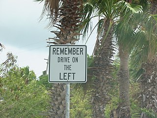
The United States Virgin Islands (USVI) is the only place under United States jurisdiction where the rule of the road is to drive on the left. However, virtually all passenger vehicles are left hand drive due to imports of U.S. vehicles.
Saint Croix is an island in the Caribbean Sea, and a county and constituent district of the United States Virgin Islands (USVI), an unincorporated territory of the United States.

Saint Thomas is one of the Virgin Islands in the Caribbean Sea which, together with Saint John, Water Island, Hassel Island, and Saint Croix, form a county-equivalent and constituent district of the United States Virgin Islands (USVI), an unincorporated territory of the United States. The territorial capital and port of Charlotte Amalie is located on the island. In the 2010 census, the population of Saint Thomas was 51,634, about 48.5% of the US Virgin Islands total. As of the 2020 census, the population of Saint Thomas is 42,461. The district has a land area of 32 square miles (83 km2).

Salt River Bay National Historic Park and Ecological Preserve is a unit of the National Park Service on the island of St. Croix in the U.S. Virgin Islands. It preserves upland watersheds, mangrove forests, and estuarine and marine environments that support threatened and endangered species. It also contains the Columbus Landing Site, a National Historic Landmark that is the only known site where members of a Columbus expedition set foot on what is now United States territory. The site is marked by Fort Salé, a remaining earthworks fortification from the French period of occupation, about 1617. The park also preserves prehistoric and colonial-era archeological sites including the only existing example of a ball court in the US Virgin Islands.
Scouting in the United States Virgin Islands has a long history, from the 1920s to the present day, serving thousands of youth in programs that suit the environment in which they live.
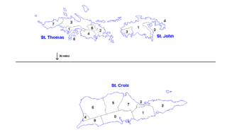
The territorial government of the United States Virgin Islands has for operational purposes established two districts, which include the minor islets nearest to the major islands:
- Saint Croix
- Saint Thomas and Saint John

Surface water is water located on top of the Earth's surface, and may also be referred to as blue water. In common usage, it is usually used specifically for terrestrial (inland) waterbodies, the vast majority of which is produced by precipitation and runoff from nearby higher areas. As the climate warms in the spring, snowmelt runs off towards nearby streams and rivers contributing towards a large portion of human drinking water. Levels of surface water lessen as a result of evaporation as well as water moving into the ground becoming ground-water. Alongside being used for drinking water, surface water is also used for irrigation, wastewater treatment, livestock, industrial uses, hydropower, and recreation. It is recorded by the Environmental Protection Agency (EPA), that approximately 68 percent of water provided to communities comes from surface water. For USGS water-use reports, surface water is considered freshwater when it contains less than 1,000 milligrams per liter (mg/L) of dissolved solids.

The United States Geological Survey, abbreviated USGS and formerly simply known as the Geological Survey, is a scientific agency of the United States government. The scientists of the USGS study the landscape of the United States, its natural resources, and the natural hazards that threaten it. The organization's work spans the disciplines of biology, geography, geology, and hydrology. The USGS is a fact-finding research organization with no regulatory responsibility.
Great Pond is a 50 ha saline coastal lagoon on the south-eastern shoreline of the island of Saint Croix in the United States Virgin Islands.
The St. Croix East End Marine Park (STXEEMP) was established to “protect territorially significant marine resources, and promote sustainability of marine ecosystems, including coral reefs, sea grass beds, wildlife habitats and other resources, and to conserve and preserve significant natural areas for the use and benefit of future generations.” It is the U.S. Virgin Islands’ first territorially designated and managed marine protected area (MPA).
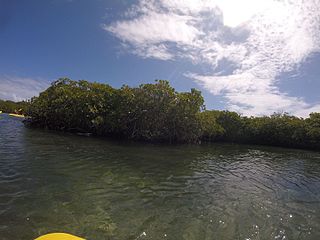
United States Virgin Islands Mangroves are flowering trees that occupy the majority of the wetlands in the Virgin Islands. These mangroves typically grow in areas that are close to the shore and thrive in oxygen-deprived, water-logged soils and salty conditions. In the Virgin Islands, there are three types of mangroves: red, black and white mangroves.

Albert Bryan Jr. is an American Virgin Islander politician who is the ninth elected governor of the United States Virgin Islands, since 2019. He was commissioner of labor from 2007 to 2015.
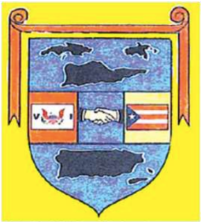
Virgin Islands – Puerto Rico Friendship Day is a public holiday celebrated in the U.S. Virgin Islands on the second Monday in October.

The 1867 Virgin Islands earthquake and tsunami occurred on November 18, at 2.45 p.m. in the Anegada Trough about 20 km southwest of Saint Thomas, Danish West Indies. The Ms 7.5 earthquake came just 20 days after the devastating San Narciso Hurricane in the same region. Tsunamis from this earthquake were some of the highest ever recorded in the Lesser Antilles. Wave heights exceeded 10 meters in some islands in the Lesser Antilles. The earthquake and tsunami reaulted in no more than 50 fatalities, although casualties in the hundreds is also claimed.
