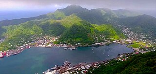
Pago Pago is the capital of American Samoa. It is in Maoputasi County on Tutuila, which is American Samoa's main island.
The National Park of American Samoa is a national park in the United States territory of American Samoa, distributed across four islands: Tutuila, Ofu, Olosega, and Ta‘ū. The park preserves and protects coral reefs, tropical rainforests, fruit bats, and the Samoan culture. Popular activities include hiking and snorkeling. Of the park's 8,257 acres (3,341 ha), 2,500 acres (1,000 ha) is coral reefs and ocean. The park is the only American National Park Service system unit south of the equator.
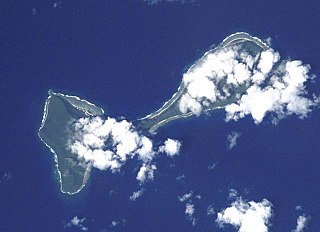
Ofu and Olosega are parts of a volcanic doublet in the Manuʻa Islands, which is a part of American Samoa in the Samoan Islands. These twin islands, formed from shield volcanoes, have a combined length of 6 km and a combined area of 12 square kilometers. Together, they have a population of about 500 people. Geographically, the islands are volcanic remnants separated by the narrow, 137-meter-wide (449-foot)) Āsaga Strait, composed of shallow-water coral reef. Before 1970, people crossed between the two islands by waiting until low tide and then wading across the shallow water of the strait. Since 1970, there has been a bridge over the strait, providing a single-lane road that connects the two islands.

Tutuila is the largest and most populous island of American Samoa and is part of the archipelago of the Samoan Islands. It is the third largest island in the Samoan Islands chain of the Central Pacific. It is located roughly 4,000 kilometers (2,500 mi) northeast of Brisbane, Australia and lies over 1,200 kilometers (750 mi) to the northeast of Fiji. It contains a large, natural harbor, Pago Pago Harbor, where Pago Pago, the capital of American Samoa, is situated. Pago Pago International Airport is also located on Tutuila. The island's land expanse is about 68% of the total land area of American Samoa. With 56,000 inhabitants, it is also home to 95% of the population of American Samoa. The island has six terrestrial and three marine ecosystems.

Pago Pago International Airport, also known as Tafuna Airport, is a public airport located 7 miles (11.3 km) southwest of the central business district of Pago Pago, in the village and plains of Tafuna on the island of Tutuila in American Samoa, an unincorporated territory of the United States.

Aunuʻu is a small volcanic island off the southeastern shore of Tutuila in Saʻole County, American Samoa. It has a land area of 374.83 acres, and a 2010 census population of 436 persons. Politically, it is a part of the Eastern District, one of the two primary political divisions of American Samoa.

The Western District is one of the three primary divisions of American Samoa. It consists of the western portion of Tutuila Island. It has a land area of 74.781 km2 and contains 29 villages plus a part of Nuʻuuli village. Among these is the largest village of American Samoa, Tafuna, at its eastern end. The district's total population as of the 2010 census was 31,329.
Aūa is a village on Tutuila Island in American Samoa. It is located along American Samoa Highway 001, and is the southern terminus of American Samoa Highway 006. Aūa is located at the foothills of Mount Peiva on the eastern shore of Pago Pago Bay. The hamlet of Leloaloa is also a part of Aūa.

Faleolo International Airport is an airport located 40 kilometres (25 mi) west of Apia, the capital of Samoa. Until 1984, Faleolo could not accommodate jets larger than a Boeing 737. Services to the United States, Australia, or New Zealand, could only land at Pago Pago International Airport in American Samoa. Since the airport's expansion, most international traffic now uses Faleolo.

Leone is the second-largest city on Tutuila Island's west coast. The village is on the south-west coast of Tutuila Island, American Samoa. Leone was the ancient capital of Tutuila Island. Leone was also where the Samoan Islands’ first missionary, John Williams, visited on October 18, 1832. A monument in honor of Williams has been erected in front of Zion Church. Its large church was the first to be built in American Samoa. It has three towers, a carved ceiling and stained glass. Until steamships were invented, Leone was the preferred anchorage of sailing ships which did not risk entering Pago Pago Harbor. Much early contact between Samoans and Europeans took place in Leone.
Nu'uuli is a village on the central east coast of Tutuila Island, American Samoa. It is located on a peninsula several miles up from Pago Pago International Airport. Nu’uuli is located between Pago Pago International Airport and Coconut Point. It is a shopping district which is home to stores, groceries and many more shops.

Tafuna is a village in Tualauta County, Western District, American Samoa. It is the most populous village in American Samoa, with a population of 7,988 according to the 2020 U.S. Census, and is the center of nightlife on island.

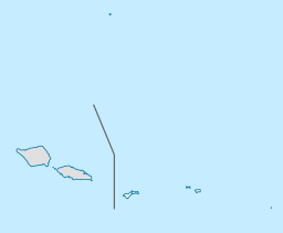
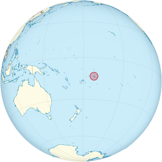
American Samoa is an unincorporated territory of the United States located in the South Pacific Ocean, southeast of the island country of Samoa. Centered on 14.3°S 170.7°W, it is east of the International Date Line and the Wallis and Futuna Islands, west of the Cook Islands, north of Tonga, and some 500 kilometers (310 mi) south of Tokelau. American Samoa is the southernmost territory of the United States and one of two U.S. territories south of the Equator, along with the uninhabited Jarvis Island.
Fagaʻalu is a village in central Tutuila Island, American Samoa. It is also known as Fagaʻalo. It is located on the eastern shore of Pago Pago Harbor, to the south of Pago Pago. American Samoa's lone hospital, Lyndon B. Johnson Tropical Medical Center, is located in Fagaʻalu. The village is centered around Fagaalu Stream.
Aʻasu or Āsu is a village on the north coast of Tutuila Island, American Samoa. It is located to the west of Fagasa and northwest of Pago Pago. It is one of multiple villages involved in an archaeological survey of the island. Aʻasu lies on Massacre Bay and can be reached from a hiking trail in Aʻasufou. Massacre Bay can be visited by car, aiga buses, or through excursions offered by North Shore Tours.

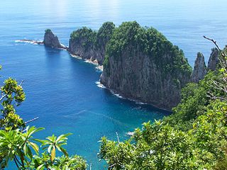
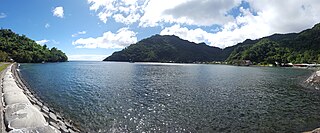
Vatia is a village on Tutuila Island in American Samoa. It is a north shore village located on Vatia Bay. The road to Vatia, American Samoa Highway 006, is the only road going through National Park of American Samoa. Vatia is a scenic community at the foot of Pola Ridge and surrounded by the national park. It is only reached by Route 6 which traverses the national park before reaching Vatia. There was once a hiking trail over Maugaloa Ridge from Leloaloa, but since the completion of Route 6, this trail is now overgrown. It is home to a beach, and panoramic views of jungle-covered peaks surround the village on all sides. Vatia is the center of the Tutuila-section of National Park of American Samoa. It is located in Vaifanua County.
Fagasā is a village in the Eastern District of Tutuila Island in American Samoa. The village lies by Fagasa Bay, on the north shore of the island. Its name is Samoan and translates to "Forbidden Bay." The village borders the Tutuila-section of National Park of American Samoa. The trailhead to Mount 'Alava is located near the village by Fagasa Pass.
Naval Base Upolu was a naval base built by the United States Navy in 1942 to support the World War II effort. The base was located on Upolu Island, Samoa in the Western Pacific Ocean, part of the Samoan Islands's Naval Base Samoa. After the surprise attack on Naval Station Pearl Harbor on December 7, 1941, the US Navy was in need of setting up more advance bases in the Pacific Ocean. At Naval Base Upolu the Navy built a sea port, an airbase and a seaplane base.