List of lakes of Pakistan

Last updated

Pakistan is home to many natural and man-made lakes and reservoirs. The largest lake in Pakistan is the Manchar Lake. The lake is spread over an area of over 260 square kilometres (100 square miles). [1]

Contents

The highest lakes in Pakistan are the Paristan Lake and Shimshal Lake, which both are at an altitude of over 4,755 metres (15,600 ft). [2] The second-highest lake in Pakistan is the Karambar Lake, which is located at an altitude of 4,272 metres (14,016 ft), is the 33rd highest lake in the world. [3] A recent Google map analysis revealed more than 500 lakes in northern Pakistan (mainly Gilgit-Baltistan and Chitral region), many of these lakes are still nameless and even undiscovered to even local population.

Natural lakes

Gilgit-Baltistan

NameImageElevationLocationDescriptionRef.
Attabad Lake Attabad a miracle in Disaster.jpg Hunza Valley, Gilgit-Baltistan

36°20′12.62″N74°52′3.12″E / 36.3368389°N 74.8675333°E / 36.3368389; 74.8675333 (Attabad Lake)

With the area of about 13.5 square km it the largest lake of Gilgit-Baltistan. Also known as Hunza Lake the lake was created in January 2010 due to massive landslides blocking Hunza River. [4]
Barah Lake Lake and Glacier.png 4,512 metres (14,803 ft) Barah Valley, Ghanche District, Gilgit-Baltistan

35°05′46″N76°14′00″E / 35.095989°N 76.233240°E / 35.095989; 76.233240 (Barah Lake)

Barah lake referred to two lakes in the mountain of Barah town. The area of this lake is 0.21 km2
Batura Lake 2,900 metres (9,500 ft) Batura valley, Hunza District, Gilgit-Baltistan The Lake lies in the Upper Hunza region of Gilgit-Baltistan in Pakistan. It is just north of the massifs of Batura, at 7,795 metres (25,574 ft), and Passu, at 7,500 metres (24,600 ft). The glacier flows west to east.
Borith Lake Lake Borith.JPG 2,600 metres (8,500 ft) Hunza, Gilgit–Baltistan

36°25′51″N74°51′46″E / 36.430863°N 74.862773°E / 36.430863; 74.862773 (Borith Lake)

Borith Lake is a saline water lake, located to the north of Ghulkin Glacier in a village near Hussaini, Gojal, in the upper Hunza. [5] [6]
Dakholi Lake Dakholi lake.jpg 4,771.1 metres (15,653 ft) Khaplu Valley, Gilgit–Baltistan

35°03′51″N76°22′41″E / 35.06417°N 76.37815°E / 35.06417; 76.37815 (Dakholi Lake)

Area of Dakholi Lake as calculated by QT at ArcGIS Esri is 0.07 km2 as of September 2020.
Ghanche Lake 4,599.9 metres (15,092 ft) Khaplu Valley, Gilgit–Baltistan

35°04′28″N76°17′37″E / 35.07457°N 76.29370°E / 35.07457; 76.29370 (Ghanche Lake)

Ghanche lake is the source of ghanche stream that waters khaplu town. The area of Ghanche Lake calculated by Arc GIS as of September 2020 by QT is 0.16 km2.
Ghorashe Lake 2,862.2 metres (9,390 ft) Kharmang Valley, Gilgit–Baltistan

34°59′06″N76°12′34″E / 34.98489°N 76.20958°E / 34.98489; 76.20958 (Ghorashe Lake)

Handarap Lake Shandoor.Jpeg 3,285 metres (10,778 ft) Ghizer Valley, Gilgit–Baltistan

36°04′05″N72°32′46″E / 36.068°N 72.546°E / 36.068; 72.546 (Handarap Lake)

Also known as Shandoor Lake.
Hasanabad Lake 2,750 metres (9,020 ft) Hassanabad Valley, Hunza District, Gilgit-Baltistan Hasanabad lake also known as Shispare lake, located in Hassanbad valley off Hunza, formed due to blockage of Shispare Glacier, thus forming a lake having 1.4 km in length. The area of this lake is 0.35 km2( growing day by day). It is 2 hours hike from hassanabad bridge, from where you can go to Batura (7795m), Shispare (7611m), Muchu Chhish (7452m) which is also the highest legal unclimbed mountain in the world and many other 7000m mountains.
Hrkolong Lake 4,126 metres (13,537 ft) Khaplu Valley, Gilgit–Baltistan

35°05′04″N76°21′24″E / 35.08440°N 76.35653°E / 35.08440; 76.35653 (Hrkolong Lake)

Hrkolong lake is the source of Hnajuluba stream that waters khaplu, Surmo and youchung broq (high steppes fields).
Khalti Lake Khalti-lake....., pakistan.jpg Khalti, Ghizer District

36°14′53″N73°21′48″E / 36.2479302°N 73.3633701°E / 36.2479302; 73.3633701 (Khalti Lake)

[7]
Paristan Lake Skardu, Skardu District
Katpanah lake Katpana lake skardu.jpg 2,190 metres (7,190 ft)Katpanah, Skardu Valley

35°18'57.8"N 75°34'42.5"E

The only lake in downtown of skardu city.
Naltar lakes Naltar Blue lake Gilgit.JPG Naltar Valley, Gilgit-Baltistan These are three lakes. [8]
Lower Kachura Lake Lower kachura shangrila resort.jpg 2,500 metres (8,200 ft) Skardu District, Gilgit–Baltistan

35°25′40″N75°27′16″E / 35.42778°N 75.45444°E / 35.42778; 75.45444 (Lower Kachura Lake)

The lake is also known as Shangrila Lake and is located at a drive of about 20 minutes from Skardu town. Shangrila was named after a book titled Lost Horizon by James Hilton. Shangri-la is a Chinese word meaning "Heaven on earth". [9]
Phander Lake Phander Lake, Ghizer, Gilgit-Baltistan.jpg Gupis-Yasin District, Gilgit-Baltistan

36°10′23″N72°56′50″E / 36.173123°N 72.9472983°E / 36.173123; 72.9472983 (Phander Lake)

Rama Lake Rama Lake.jpg 2,600 metres (8,500 ft) Astore Valley, Gilgit–Baltistan

35°19′51″N74°47′8″E / 35.33083°N 74.78556°E / 35.33083; 74.78556 (Rama Lake)

Rama Lake is located nine kilometers away from the valley of Astore in Northern Areas. [10]
Rush Lake Rush lake.JPG 4,693 metres (15,397 ft) Nagar Valley, Gilgit–Baltistan

36°7′50″N74°55′57″E / 36.13056°N 74.93250°E / 36.13056; 74.93250 (Rush Lake)

Rush Lake is a high altitude lake located near Rush Pari Peak. At over 4,694 meters, Rush is the highest lake in Pakistan and one of the highest alpine lakes in the world. It is located about 15 km north of Miar Peak and Spantik (Golden Peak), which are in the Nagar valley. [3] [11]
Satpara Lake SatparaLakeSkardu1199.jpg 2,636 metres (8,648 ft) Skardu Valley, Gilgit–Baltistan

35°14′2″N75°37′53″E / 35.23389°N 75.63139°E / 35.23389; 75.63139 (Satpara Lake)

Satpara Lake is located in Skardu Valley and is one of the (Area=4.5square km, 2nd largest of gilgit baltistan)largest fresh water lakes in Pakistan. It supplies water for the town of Skardu. [12]
Sheosar Lake Sheosar-lake.jpg 4,142 metres (13,589 ft) Deosai Plains, Gilgit–Baltistan

34°59′30.35″N75°14′43.42″E / 34.9917639°N 75.2453944°E / 34.9917639; 75.2453944 (Sheosar Lake)

Sheosar Lake is situated in the Deosai Plateau, which is one of the highest plateaus of the world. [3] [13] [14]
Shimshal Lakes 4,755 metres (15,600 ft) Hunza District, Gilgit–Baltistan

Shimshal Lakes, Hunza

There are 2 lakes having a height of 4,755 metres (15,600 ft), making it the highest lake in Pakistan. These lakes are almost 3 hours hiking from Shimshal valley in Hunza, Gilgit Baltistan, Pakistan.
Upper Kachura Lake KachuraUpper1075.JPG 2,500 metres (8,200 ft) Skardu District, Gilgit–Baltistan

35°26′48″N75°26′44″E / 35.44667°N 75.44556°E / 35.44667; 75.44556 (Upper Kachura Lake)

The lake is surrounded with wild apricot gardens and has a depth of around 70 meters. Due to rough terrain of the surrounding area, this lake is not well explored.
Zharba Lake 2,500 metres (8,200 ft) Shigar Valley, Gilgit–Baltistan The only lake in Shigar valley.

Azad Kashmir, Punjab, KPK, Sindh and Balochistan

NameImageElevationLocationDescriptionNotes
Ansoo Lake Ansoo Lake.jpg 4,126 metres (13,537 ft) Kaghan Valley, Khyber Pakhtunkhwa

34°48′53.75″N73°40′33.10″E / 34.8149306°N 73.6758611°E / 34.8149306; 73.6758611 (Ansoo Lake)

Ansoo Lake is a high-altitude lake (4,126 metres (13,537 ft)) located in the Kaghan Valley in Mansehra District of Khyber Pakhtunkhwa. It is near Malika Parbat in the Himalayan range. [15]
Baghsar Lake 975 metres (3,199 ft) Samahni Valley, Bhimber District

33°2′42″N74°11′50″E / 33.04500°N 74.19722°E / 33.04500; 74.19722 (Baghsar Lake)

The lake is nearly half a kilometer long and overlooks the Bandala Valley. [16]
Bashkargol Lake Bashkargol Lake in early morning.jpg 3,652 metres (11,982 ft) Chitral Valley, Khyber Pakhtunkhwa

35°54′45.72″N72°19′59.83″E / 35.9127000°N 72.3332861°E / 35.9127000; 72.3332861 (Bashkargol Lake)

Bashkargol Lake is a high-altitude lake (3,652 metres (11,982 ft)) located in the Laspur Valley in Upper Chitral District of Khyber Pakhtunkhwa. It is near Thalo Zom in the Hindukush range. Roughly 22 kilometer hike from the village of Sor Laspur. [17]
Chitta Katha Lake Lake of Chitta Khatta, Kashmir.jpg 3,962 metres (12,999 ft)Shonter Valley, Azad Kashmir

34°55′8″N74°31′17″E / 34.91889°N 74.52139°E / 34.91889; 74.52139 (Chitta Katha Lake)

Chitta Katha Lake is located in Shonter Valley of Azad Kashmir. [18]
Drigh Lake Drigh Lake.jpg Qambar Shahdadkot District, Sindh

27°34′05″N67°55′48″E / 27.568°N 67.930°E / 27.568; 67.930

Drigh Lake is Located in Qambar Shahdadkot District in Sindh, Pakistan, It is 29 km away from Larkana city and 7 km away from Qambar town. [19]
Dudipatsar Lake Dudipat lake1.jpg 3,800 metres (12,500 ft) Kaghan Valley, Khyber Pakhtunkhwa

35°1′6.6″N74°5′22.2″E / 35.018500°N 74.089500°E / 35.018500; 74.089500 (Dudipatsar Lake)

The lake lies in the extreme north of Kaghan Valley at a height of 3,800 metres (12,500 ft). The term dudi in Urdu means white and sar means lake. [20]
Dudibach Sar Kaghan Valley, Khyber Pakhtunkhwa

35°1′0.12″N74°4′59.88″E / 35.0167000°N 74.0833000°E / 35.0167000; 74.0833000 (Dudibach Sar)

[21]
Karambar Lake Qurumber Lake in Baroghil Valley, famous for its pristine water, Pakistan.jpg 4,272 metres (14,016 ft) Boroghil Valley, Chitral

36°53′03.26″N73°42′44.03″E / 36.8842389°N 73.7122306°E / 36.8842389; 73.7122306 (Karambar Lake)

Karambar Lake is the 33rd highest lakes in the world. The approximate length of the lake is 3.9 km, width is 2 km and, average depth is 52m. [3] [22]
Ganga Lake Bagh District, Azad Kashmir
Hadero Lake Thatta District, Sindh

24°49′42″N67°51′37″E / 24.82833°N 67.86028°E / 24.82833; 67.86028 (Hadero Lake)

Hadero is a brackish water lake in Sindh. The lake was declared wildlife sanctuary in 1977. The lake has a surface area of 1321 hectares.

[23]

Haleji Lake Halaji Lake.jpg Thatta, Sindh

24°48′10″N67°46′38″E / 24.80278°N 67.77722°E / 24.80278; 67.77722 (Haleji Lake)

The lake is located at about 70 km from Karachi and is the largest water fowl reserve in Asia. [24] [25]
Hamal Lake Qamber Shahdadkot District, Sindh

27°26′56″N67°37′55″E / 27.449°N 67.632°E / 27.449; 67.632 (Hamal Lake)

Hamal Lake is located in Qamber Shahdadkot District in Sindh, Pakistan. [26]
Hanna Lake Imagehanna lake.jpg 1,898 metres (6,227 ft) Quetta, Balochistan

30°15′N67°06′E / 30.250°N 67.100°E / 30.250; 67.100 (Hanna Lake)

Hanna Lake is located 10 km from Quetta, near Urak Valley in Balochistan. [27]
Jahlar Lake828 metres (2,717 ft) Soon Valley, Punjab

32°29′53.26″N72°5′15.19″E / 32.4981278°N 72.0875528°E / 32.4981278; 72.0875528 (Jahlar)

Jahlar Lake is part of Uchhali Wetland Complex in Soon Valley
Kallar Kahar Lake Kalar Kahaar.jpg Chakwal District, Punjab

32°47′N72°42′E / 32.783°N 72.700°E / 32.783; 72.700 (Kallar Kahar)

The salt water lake is located near Salt Range in Chakwal District, 125 km from Rawalpindi. [28]
Keenjhar Lake PK Keenjhar Lake near Thatta asv2020-02 img3.jpg 21 metres (69 ft) Thatta, Sindh

24°57′N68°03′E / 24.950°N 68.050°E / 24.950; 68.050 (Keenjhar Lake)

The lake is also called Kalri Lake and is one of the largest freshwater lakes in Pakistan. The Sindhi legend of Noori Jam Tamachi took place around the lake, and to this day there is a shrine in the middle of the lake marking Noor's grave. [24] [27]
Khabikki Lake Khabeki Lake (2).jpg Khushab District, Punjab

32°37′19″N72°12′49″E / 32.621882°N 72.21355°E / 32.621882; 72.21355 (Khabikki Lake)

It is a salt water lake located in the southern Salt Range. The lake is named after a nearby village, Khabikki. [29]
Kundol Lake Kundol Lake, Utror Valley.jpg 2,743 metres (8,999 ft) Utror, Swat Valley, Khyber Pakhtunkhwa

35°19′57″N72°29′50″E / 35.33250°N 72.49722°E / 35.33250; 72.49722 (Kundol Lake)

This lake is located in the north of Utror via Ladu valley.
Lulusar Lake Lulusar.jpg 3,410 metres (11,190 ft) Naran Valley, Khyber Pakhtunkhwa

35°0′8.04″N73°9′2.66″E / 35.0022333°N 73.1507389°E / 35.0022333; 73.1507389 (Lulusar Lake)

The lake is the main source of the Kunhar River and has a baby lake beside it. The word "sar" means "lake" in Shina. [30]
Mahodand Lake Mahodand Lake.jpg 2,900 metres (9,500 ft) Kalam Valley, Khyber Pakhtunkhwa

35°42′50″N72°39′01″E / 35.7138°N 72.6502°E / 35.7138; 72.6502 (Mahodand Lake)

The lake is located 40 km from Kalam Valley in the valley of Ushu. [31]
Manchar Lake Manchar SPOT 1299.jpg 34 metres (112 ft) Sindh

26°25′00″N67°39′00″E / 26.4166°N 67.65°E / 26.4166; 67.65 (Manchar Lake)

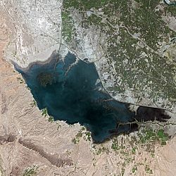
Lake Manchar is the largest freshwater lake in Pakistan and one of the largest in Asia. It is located west of the Indus River in Sindh. The area of the lake fluctuates with the seasons from as little as 350 km2 to 520 km2. The lake collects water from numerous small streams in the Kirthar Mountains and empties into the Indus River. [24] [32]
Namal Lake Namal Lake.png Mianwali, Punjab

32°41′23″N71°48′24″E / 32.689597°N 71.806763°E / 32.689597; 71.806763 (Namal Lake)

Namal Lake is located in Namal Valley, in Mianwali. The lake is spread over an area of 5.5 km2 and was built in 1913 after the construction of Namal Dam. [33]
Payee Lake Paaye Lake.jpg 2,895 metres (9,498 ft) Kaghan Valley, Khyber Pakhtunkhwa

34°36′55″N73°29′12″E / 34.6153°N 73.4867°E / 34.6153; 73.4867 (Payee Lake)

Payee Lake is located near Shogran in Payee, surrounded by the Makra Peak, Malika Parbat, and the mountains of Kashmir. [34]
Pyala Lake Payala Lake KPK.jpg 3,410 metres (11,190 ft) Kaghan Valley, Khyber Pakhtunkhwa

35°0′27.7524″N73°56′28.8852″E / 35.007709000°N 73.941357000°E / 35.007709000; 73.941357000 (Lulusar Lake)

Pyala Lake is a very small lake besides the Kunhar River at Jalkhad. Since the lake looks more like a bowl Urde:Pyala (پیالہ) hence it is called Pyala Lake. [35]
Ratti Gali Lake Ratti Gali lake azad kashmir pakistan.jpg 3,700 metres (12,100 ft) Neelam Valley, Azad Kashmir

34°49′49″N74°03′41″E / 34.8302°N 74.0613°E / 34.8302; 74.0613 (Ratti Gali Lake)

The lake is accessible from Dowarian by a 19 kilometers (12 mi) hiking trek. Dowarian is the base camp to this lake. [36]
Saiful Muluk Lake-Saif-Ul-Malook.jpg 3,224 metres (10,577 ft) Kaghan Valley, Khyber Pakhtunkhwa

34°52′37.34″N73°41′37.71″E / 34.8770389°N 73.6938083°E / 34.8770389; 73.6938083 (Saiful Muluk)

The lake is located in the northern end of Kaghan Valley. The lake has total surface area of over 2.5 square kilometer. The lake is famous for its fairytale of Saiful Maluk [37]
Saral Lake Saral Lake proper.jpg 4,100 metres (13,500 ft) Neelam Valley, Azad Kashmir

34°57′46″N74°05′59″E / 34.96282°N 74.099773°E / 34.96282; 74.099773 (Saral Lake)

This lake can be accessed from Sharda, Neelam valley and Kaghan Valley. [38]
Shakoor Lake 24°15′28″N69°04′20″E / 24.2577°N 69.0721°E / 24.2577; 69.0721 (Shakoor Lake) Shakoor Lake is situated on the border between India and Pakistan, its area ranges from 300 square kilometres (120 sq mi) [39]
Shonter Lake Shountar Lake, Shounter valley, AJK, Pakistan.jpg Neelum Valley, Azad Kashmir

34°58′23″N74°30′46″E / 34.97306°N 74.51278°E / 34.97306; 74.51278 (Shonter Lake)

This is a small lake located in the Azad Kashmir.
Siri Lake Siri Lake Shogran.jpg 2,590 metres (8,500 ft) Kaghan Valley, Khyber Pakhtunkhwa

34°37′52″N73°29′31″E / 34.6312°N 73.4920°E / 34.6312; 73.4920 (Siri Lake)

Siri Lake is situated near Shogran in Siri, on the way to Payee in Kaghan Valley, Pakistan. [40]
Spin Khwar Lake Spin Khwar Lake Swat Valley.jpg Swat Valley, Khyber Pakhtunkhwa [41]
Subri Lake Muzaffarabad, Azad Kashmir

34°19′26″N73°31′12″E / 34.324°N 73.520°E / 34.324; 73.520 (Subri Lake)

Subri lake, also known as Langarpura Lake, is situated 10 kilometers out of Muzaffarabad, where the Jhelum River widens to form the lake.
Swaik Lake (Khandowa Lake) Swaik lake.jpg Khandowa Village Kallar Kahar Tehsil, Chakwal District

36°20′12.62″N74°52′3.12″E / 36.3368389°N 74.8675333°E / 36.3368389; 74.8675333 (Attabad Lake)

Swaik Lake or Khandowa Lake(Urdu : کھنڈوعہ) is a lake situated at 10 km from the Tehsil Kallar Kahar, Chakwal District and 30 kilometers southwest of Chakwal along the motorway. [42]
Uchhali Lake Uchali Lake - Soon Skaser.JPG 1,522 metres (4,993 ft) Soan Sakaser Valley, Salt Range

32°33′25″N72°1′31″E / 32.55694°N 72.02528°E / 32.55694; 72.02528 (Uchhali Lake)

The lake is located in the southern salt range and has brackish water. [43]

Artificial lakes and reservoirs

NameImageElevationLocationDescriptionNotes
Banjosa Lake Lake of Banjosa.jpg 1,981 metres (6,499 ft) Poonch District, Azad Kashmir

33°48′38″N73°48′59″E / 33.81056°N 73.81639°E / 33.81056; 73.81639 (Banjosa Lake)

Banjosa is an artificial lake and a tourist attraction near the city of Rawalakot in District Poonch in Azad Kashmir. [44]
Chotiari Lake Sanghar District, Sindh

26°08′46″N69°09′40″E / 26.146°N 69.161°E / 26.146; 69.161 (Chotiari Lake)

Chotiari Lake is an artificial water reservoir situated 35 km away from the Sanghar town in Sanghar District, Sindh. [45]
Hub Lake Hub Dam.jpg Karachi and Lasbela District on Sindh and Balochistan border

25°16′48″N67°07′44″E / 25.280°N 67.129°E / 25.280; 67.129 (Hub Lake)

Hub Lake is an artificial reservoir 56 km away from Karachi on Sindh and Balochistan border. [46]
Khanpur Lake Khanpur lake Abbottabad.JPG Khanpur, Khyber Pakhtunkhwa

28°64′91″N 70°65′14″E

It is situated in Khanpur village, 15 kilometres (9.3 mi) from Haripur. Famous for Water sports and Paragliding. [47]
Mangla Lake Mangla Lake view from Ramkort fort.jpg Mirpur District, Azad Kashmir

33°11′56″N73°45′04″E / 33.199°N 73.751°E / 33.199; 73.751 (Mangla Lake)

Mangla Lake is an artificial reservoir near Mirpur city in Mirpur District, Azad Kashmir [48]
Rawal Lake SunrisesatRawalLakeIslamabad.jpg Islamabad

33°42′10″N73°07′34″E / 33.702675°N 73.126118°E / 33.702675; 73.126118 (Rawal Lake)

Rawal Lake is an artificial reservoir in Islamabad Capital Territory, Pakistan. The lake is spread over an area of 8.8 km2 and is one of the major sources of water for the residents of Islamabad and Rawalpindi. Rawal Lake is located within an isolated section of the Malpur village near Margalla Hills National Park. [49] [50]
Simli Lake Simly dam lake - panoramio.jpg Islamabad

33°44′5″N73°20′5″E / 33.73472°N 73.33472°E / 33.73472; 73.33472 (Simli Lake)

Simli Lake is located 30 km from Islamabad. The lake is formed from the melting snow and natural springs of Murree Hills. Simli Lake is the largest drinking water source for the residents of Islamabad. [51]
Tanda Lake Tanda-001.jpg Kohat, Khyber Pakhtunkhwa

33°35′13″N71°26′32″E / 33.58694°N 71.44222°E / 33.58694; 71.44222 (Tanda Lake)

Tanda Lake is formed from Tanda Dam in Kohat District on Toi River.[ citation needed ]
Tarbela Lake Terbela Dam Pakistan.jpg Haripur District, Khyber Pakhtunkhwa

34°07′59″N72°48′29″E / 34.133°N 72.808°E / 34.133; 72.808 (Tarbela Lake)

Tarbela Lake is an artificial reservoir in the Haripur District of North-West Frontier Province. It is near Tarbela Township in the Tarbela range. The name of the lake comes from town of Tarbela in which it is located (Hindko Black Forest). [52] [53]
Map all coordinates using: OpenStreetMap

See also

Related Research Articles

<span class="mw-page-title-main">Punjab, Pakistan</span> Province of Pakistan

Punjab, known historically as Panchanada and Pentapotamia, is a province of Pakistan. Located in central-eastern region of the country, Punjab is the second-largest province of Pakistan by land area and the largest by population. Lahore is the capital and the largest city of the province. Other major cities include Faisalabad, Rawalpindi, Gujranwala and Multan.

<span class="mw-page-title-main">Baltistan</span> Region of Pakistani-administered Kashmir

Baltistan also known as Baltiyul or Little Tibet, is a mountainous region in the Pakistani-administered territory of Gilgit–Baltistan. It is located near the Karakoram and borders Gilgit to the west, China's Xinjiang to the north, Indian-administered Ladakh to the southeast, and the Indian-administered Kashmir Valley to the southwest. The average altitude of the region is over 3,350 metres (10,990 ft). Baltistan is largely administered under the Baltistan Division.

<span class="mw-page-title-main">Karakoram Highway</span> International highway running through Pakistan and China

The Karakoram Highway is a 1,300 km (810 mi) national highway which extends from Hasan Abdal in the Punjab province of Pakistan to the Khunjerab Pass in Gilgit-Baltistan, where it crosses into China and becomes China National Highway 314. The highway connects the Pakistani provinces of Punjab and Khyber Pakhtunkhwa plus Gilgit-Baltistan with China's Xinjiang Uyghur Autonomous Region. The highway is a popular tourist attraction and is one of the highest paved roads in the world, passing through the Karakoram mountain range, at 36°51′00″N75°25′40″E at maximum elevation of 4,714 m (15,466 ft) near Khunjerab Pass. Due to its high elevation and the difficult conditions under which it was constructed, it is often referred to as the Eighth Wonder of the World. The highway is also a part of the Asian Highway AH4.

<span class="mw-page-title-main">Skardu</span> City in Gilgit-Baltistan, Pakistan

Skardu is a city located in Gilgit-Baltistan, in Pakistan. Skardu serves as the capital of Skardu District and the Baltistan Division. It is situated at an average elevation of nearly 2,500 metres above sea level in the Skardu Valley, at the confluence of the Indus and Shigar rivers. The city is an important gateway to the eight-thousanders of the nearby Karakoram mountain range. The Indus River running through the region separates the Karakoram from the Ladakh Range.

Topi is a town in the eastern part of the Swabi District of Khyber Pakhtunkhwa province of Pakistan. The administrative division of Topi unfolds into two Union councils: Topi East and Topi West. Notably, the Tarbela Dam, largest earth-filled dam in the world, is located only 9 kilometres (5.6 mi) east of Topi.

<span class="mw-page-title-main">Tarbela Dam</span> Dam in Swabi Topi Khyber Pakhtunkhwa, Pakistan

Tarbela Dam is an earth-filled dam along the Indus River in Pakistan's Khyber Pakhtunkhwa province. It is located mainly in the Swabi District Tehsil Topi of the province. It is about 20 km (10 mi) from the city of Swabi KPK, 105 km (65 mi) northwest of Islamabad, and 125 km (80 mi) east of Peshawar. It is the largest earth-filled dam in the world. The dam is 143 metres (470 ft) high above the riverbed and its reservoir, Tarbela Lake, has a surface area of approximately 250 square kilometres (97 sq mi).

<span class="mw-page-title-main">Chakwal</span> Town in Punjab, Pakistan

Chakwal is a city in Chakwal District, in the Potohar region of Punjab, Pakistan.

<span class="mw-page-title-main">Malam Jabba</span> Place in Khyber Pakhtunkhwa, Pakistan

Malam Jabba is a hill station and ski resort in the Hindu Kush mountain ranges. It is nearly 40 km far from Saidu Sharif in the Swat Valley of the Khyber Pakhtunkhwa province of Pakistan. It is 314 km far from Islamabad and 51 km from Saidu Sharif Airport.

<span class="mw-page-title-main">Lulusar</span> Alpine/glacial lake in Mansehra District, Khyber-Pakhtunkhwa

Lulusar, , or Lalusar, is a group of mountain peaks and a lake in the Kaghan Valley in the Khyber-Pakhtunkhwa province of Pakistan.

<span class="mw-page-title-main">Pakistan Tourism Development Corp</span> Organization of Government of Pakistan to promote tourism

Pakistan Tourism Development Corporation or PTDC is an organization of the Government of Pakistan. PTDC is governed by the Board of Directors and provides transportation to various areas and owns and runs several motels across the country. It was incorporated on 30 March 1970.

<span class="mw-page-title-main">Geography of Gilgit-Baltistan</span>

Gilgit-Baltistan is an administrative territory of Pakistan in the northern part of the country. It was given self-governing status on August 29, 2009. Gilgit-Baltistan comprises 14 districts within three divisions. The four districts of Skardu Kharmang Shigar and Ghanche are in the Baltistan Division, four districts of Gilgit Ghizer Hunza and Nagar districts which were carved out of Gilgit District are in the Gilgit Division and the third division is Diamir, comprising Chilas and Astore. The main political centres are the towns of Gilgit and Skardu.

<span class="mw-page-title-main">Khabikki Lake</span> Body of water in Punjab, Pakistan

Khabikki Lake is a salt water lake, in the Soan Sakaser Valley in the southern Salt Range area in Khushab District, Punjab, Pakistan. This lake is formed due to the absence of drainage in the range. It is part of Uchhali Wetlands Complex and has been designated a Ramsar site.

<span class="mw-page-title-main">Tourism in Pakistan</span> Economic sector

Tourism in Pakistan is a growing industry. In 2010, Lonely Planet termed Pakistan "tourism's 'next big thing'". The country is geographically and ethnically diverse, and has a number of historical and cultural heritage sites. Condé Nast Traveller ranked Pakistan The Best Holiday Destination for 2020 and also declared it the third-highest potential adventure destination in the world for 2020. As security in the country improves, tourism increases; in two years, it has increased by more than 300%. The Pakistani government had launched online visa services for 175 countries and 50 countries were offered visa on arrival, making visiting Pakistan easier. The country received an influx of travel vloggers, who promoted the characteristics of the country, such as in the Northern Pakistan, like Hunza and Skardu.

<span class="mw-page-title-main">Gilgit-Baltistan</span> Region administered by Pakistan

Gilgit-Baltistan, formerly known as the Northern Areas, is a region administered by Pakistan as an administrative territory and consists of the northern portion of the larger Kashmir region, which has been the subject of a dispute between India and Pakistan since 1947 and between India and China since 1959. It borders Azad Kashmir to the south, the province of Khyber Pakhtunkhwa to the west, the Wakhan Corridor of Afghanistan to the north, the Xinjiang region of China to the east and northeast, and the Indian-administered union territories of Jammu and Kashmir and Ladakh to the southeast.

<span class="mw-page-title-main">Rikhi</span> Village in Punjab, Pakistan

Rikhi (رِکھی) is a village of Punjab, Pakistan, situated on Mianwali-Rawalpindi road, on the northern side of Namal Lake. Rikhi is at a distance of 32 kilometers from Mianwali city. The name Rikhi originated from the name of Mountain Stream Rikhi which starts from salt range usually during rainy season and coming down, passing through village rikhi and then it goes to Namal lake. Previously it was called Trikhi meaning Fast Due to its Fast flow. But Later on, it changed from Trikhi to Rikhi. The people started living in Rikhi area after Shifting of population of Nammal Village. The nammal village was exactly at same place where now Nammal lake exist. During British rule,in 1913 when nammal lake was given shape of Lake and nammal Dam was Constructed, then people living there shifted to surrounding areas like Rikhi, Kalri etc. This village is part of Moza Kalri. Rikhi is part of Union Council Thamewali. Police station for Rikhi is in Chakrala. Historical Nala Rikhi still flows in the mid of the Rikhi Village during Rainy Season and enhances the beauty of the village.

<span class="mw-page-title-main">Kallar Kahar Tehsil</span> Tehsil in Punjab, Pakistan

Kallar Kahar Tehsil, is an administrative subdivision (tehsil) of Chakwal District in the Punjab province of Pakistan. Tehsil headquarters are in Kallar Kahar city.

<span class="mw-page-title-main">Naltar Lakes</span> Group of lakes in Gilgit-Baltistan, Pakistan

There are three lakes in Naltar Valley known as Naltar Lakes or Bashkiri Lakes at altitudes ranging from 3,050–3,150 metres (10,010–10,330 ft). In one of the three lakes colour of water is green while the second has blue colored water and the third has azure colored water. The first, Bashkiri Lake is located at a distance of about 12 kilometres (7.5 mi) from Upper Naltar. The road up to the lakes is a dirt road alongside a stream flowing down the valley. The lakes are surrounded by dense pine forests. The best time to visit the lakes is from May to October. During the winter, it becomes almost impossible to reach the lake by vehicle due to the heavy snowfall in the Naltar Valley.

<span class="mw-page-title-main">Abdul Hafeez Mirza</span> Pakistani tourism worker, cultural activist, educationist (1939–2021)

Abdul Hafeez Mirza was a Pakistani tourism worker, cultural activist and an educationist. He worked as general manager at Tourism Development Corporation Punjab (TDCP), and served as a Consultant for Tourism Corporation Khyber Pakhtunkwha (TCKP),formerly known as Sarhad Tourism Development Corporation. He also worked for Pakistan Tourism Development Corporation (PTDC). He worked as the managing director of a tour operating company, Montana Travel Service ltd. He was also a professor of French Language and was an Author of several books on French Language and Tourism.

<span class="mw-page-title-main">Discover Pakistan TV</span> Television channel

Discover Pakistan TV is a Pakistani television channel based in Lahore, Pakistan.

References

  1. "World Bodies of Water Cheatsheet". LASA University. 9 July 2008. Retrieved 9 January 2009.
  2. "Karachi-based mountaineers discover Pakistan's 'highest' lake". www.thenews.com.pk. Retrieved 25 February 2022.
  3. 1 2 3 4 "The Highest Lake in the World". highestlake.com. 22 September 2004. Retrieved 9 January 2009.
  4. "Attabad Lake - Hunza Valley". atlasobscura.com. Atlas Obscura . Retrieved 4 November 2019.
  5. "Ghulkin Village". Hashoo Group. Pearl Tours and Travels. Archived from the original on 20 November 2008. Retrieved 9 January 2009.
  6. "Borith Lake". X̌ik-Wakhi. 31 July 2008. Retrieved 9 January 2009.
  7. Mir, Shabbir (25 January 2016). "Secret attraction: Frozen Khalti Lake becomes winter sporting arena". The Express Tribune . Retrieved 4 November 2019.
  8. "Naltar Lakes in Naltar Valley". skardu.pk. Retrieved 25 August 2018.
  9. "Shangrila Lake | James Hilton Novel". skardu.pk. 19 November 2016. Retrieved 4 November 2019.
  10. "Rama Lake". Tourism Development Corporation of Punjab (TDCP). Archived from the original on 3 June 2013. Retrieved 9 January 2009.
  11. "Rush Lake". EcoExpeditions. Archived from the original on 26 May 2003. Retrieved 9 January 2009.
  12. "Satpara Lake". Tourism Development Corporation of Punjab (TDCP). Archived from the original on 3 June 2013. Retrieved 9 January 2009.
  13. "Skardu Pakistan". GLOBOSapiens, Germany. 11 August 2007. Retrieved 9 January 2009.
  14. "Sheosar Lake @ Deosai". flickr. 12 March 2006. Retrieved 9 January 2009.
  15. "Ansoo Lake". World 66. 9 July 2008. Archived from the original on 2 May 2013. Retrieved 9 January 2009.
  16. "Baghsar". Yahoo GeoCities. Archived from the original on 25 October 2009. Retrieved 10 January 2009.
  17. "Bhashkar Gol Lake - Sorlas Pur Village trek". wikiloc.com. Retrieved 28 August 2022.
  18. "About Pakistan". Dollar East. Archived from the original on 5 January 2009. Retrieved 9 January 2009.
  19. "Drigh Wildlife Sanctuary". Sindh wildlife Department. Archived from the original on 4 May 2013. Retrieved 18 June 2012.
  20. "15 of the most beautiful lakes in Pakistan". ARY News . 27 March 2018. Retrieved 4 November 2019.
  21. "Dudibach Sar Travel Guide". Virtual Tourist. 21 October 2005. Retrieved 28 June 2012.
  22. "Karumbar Lake". Murree.com. Archived from the original on 26 May 2013. Retrieved 9 January 2009.
  23. "Hudero Sanctuary". Sindh Wildlife Department. Archived from the original on 3 December 2008. Retrieved 10 January 2009.
  24. 1 2 3 "Picturesque Lakes of Pakistan". Pakistan Paedia. Retrieved 9 January 2009.
  25. "Haliji Lake". Tourism Development Corporation of Punjab (TDCP). Archived from the original on 3 June 2013. Retrieved 9 January 2009.
  26. "Killer lake continues to bring misery". The News. 29 November 2009. Archived from the original on 21 October 2012. Retrieved 18 June 2012.
  27. 1 2 "Pakistan Lakes". US National Imagery and Mapping Agency. Index Mundi. 22 January 2006. Retrieved 9 January 2009.
  28. "Kallar Kahar Map". Google Maps World Gazetter. MapLandia. Retrieved 10 January 2009.
  29. "Khabikki Lake". Tourism Development Corporation of Punjab (TDCP). Archived from the original on 3 June 2013. Retrieved 10 January 2009.
  30. "Lulusar Lake". Tourism Development Corporation of Punjab (TDCP). Archived from the original on 3 June 2013. Retrieved 9 January 2009.
  31. "Mohodand Lake". Tourism Development Corporation of Punjab (TDCP). Archived from the original on 3 June 2013. Retrieved 9 January 2009.
  32. "Pakistan Lakes". US National Imagery and Mapping Agency. Index Mundi. 22 January 2006. Retrieved 9 January 2009.
  33. "Namal Lake". Freebase. Archived from the original on 1 May 2013. Retrieved 30 January 2009.
  34. "Makra-Payee Lake". Peakware.com. Archived from the original on 4 March 2016. Retrieved 10 January 2009.
  35. "Pyala Lake" . Retrieved 11 June 2015.
  36. "Neelum adventure". Archived from the original on 18 November 2013. Retrieved 11 June 2013.
  37. "Saiful Malook Lake". Tourism Development Corporation of Punjab (TDCP). Archived from the original on 3 June 2013. Retrieved 9 January 2009.
  38. Naran Valleys Travel Guide Retrieved 18 June 2012.
  39. "Relevance of Sir Creek" . Retrieved 6 August 2014.
  40. Kaghan Valley: There's no place like it Retrieved 23 July 2012
  41. "Spin Khwar (White Stream) Lake". Swat Valley Tourism. Retrieved 14 July 2012.
  42. "Swaik Lake - Kallar Kahar". www.spotsclick.com. Retrieved 24 August 2018.
  43. "Uchali Lake, Soon Valley". Visitsoonvalley.com. Retrieved 24 August 2018.
  44. "Banjosa Lake". ajktourism.gov.pk. Retrieved 4 November 2019.
  45. "Chotiari reservoir affectees". Dawn news. 31 October 2011. Retrieved 12 July 2012.
  46. "Hub Dam". Eco Tourism Development In Pakistan. Archived from the original on 14 January 2016. Retrieved 21 June 2012.
  47. "Khanpur Lake, Hazara Division". www.pakistantoursguide.com. Retrieved 24 August 2018.
  48. "Mangla Lake". Tourism in Pakistan. Archived from the original on 2 May 2013. Retrieved 13 July 2012.
  49. "Rawal Lake | Special Information". global-geography.org. Retrieved 4 November 2019.
  50. "Lake & Dams in Pakistan". Archived from the original on 11 April 2012. Retrieved 24 November 2008.
  51. "Simli Lake". Tourism Development Corporation of Punjab (TDCP). Archived from the original on 3 June 2013. Retrieved 9 January 2009.
  52. "Tarbela Dam Project, Haripur District". www.water-technology.net. Retrieved 25 August 2018.
  53. "Tarbela Lake". Dawn . Retrieved 25 August 2018.