Related Research Articles

The Iranian plateau or Persian plateau is a geological feature spanning parts of West Asia, Central Asia, and South Asia. It makes up part of the Eurasian Plate, and is wedged between the Arabian Plate and the Indian Plate. The plateau is situated between the Zagros Mountains to the west, the Caspian Sea and the Köpet Dag to the north, the Armenian Highlands and the Caucasus Mountains to the northwest, the Strait of Hormuz and the Persian Gulf to the south, and the Indian subcontinent to the east.
Shadi Kaur Dam was a dam located on the Shadi Kaur river about 50 kilometres north of Pasni in Balochistan province of Pakistan. The dam was 485 metres long. It was constructed in 2003 at a cost of 45 million Pakistani Rupees ($758,853) to provide irrigation for nearby farms.

Hub Dam is a reservoir on the Hub River. It is situated 56 km from Karachi city in Karachi and Hub District on Sindh and Balochistan provinces border. The dam is extended to 24300 acres with gross storage capacity of 857000 acre feet. It is Pakistan's fifth-largest dam. It is an important source that provides the drinking water to the metropolitan city Karachi.

Zhob River is located in Balochistan and Khyber Pakhtunkhwa, Pakistan. The total length of the Zhob River is 410 km, and it flows on a generally northeasterly course.
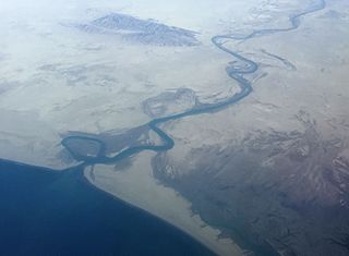
The Dasht River is located in the Makran region and Gwadar District, in the southwestern section of Balochistan Province, Pakistan which drains near Jiwani.
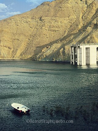
Miraani Dam. Dasht River south of the Central Makran Range in Kech District in Balochistan province of Pakistan. Its 302,000 acre-feet (373,000,000 m3) reservoir is fed by the Kech River and the Nihing River. Mirani Dam was completed in July 2006 and began impounding the Dasht River in August 2006.
Nasirabad Division is an administrative division of Balochistan Province, Pakistan. It is the only Irrigation & Agricultural Division of Balochistan, The division connects Balochistan with Sindh. Nasirabad division created by bifurcation of Sibi division in 1987. Its Divisional headquarters are at Dera Murad Jamali.
The Kech River flows in the Makran region, of southeastern Iran and the southwestern area of Balochistan Province in southwestern Pakistan.

The Sharda River, also called Kali River and Mahakali River, originates at Kalapani in the Himalayas at an elevation of 3,600 m (11,800 ft) in the Pithoragarh district in Uttarakhand, India. It flows along Nepal's western border with India and has a basin area of 14,871 km2 (5,742 sq mi). It joins Ghaghra River, a tributary of the Ganges. It takes the name Kali River from the union of the two streams at Gunji as it flows through the hills. After Brahmadev Mandi near Tanakpur, it enters the Terai plains, where it is called Sharda River.

The topography of Pakistan is divided into seven geographic areas: the northern highlands, the Indus River plain, the desert areas, the Pothohar Plateau, Balochistan Plateau, Salt Range, and the Sistan Basin. All the rivers of Pakistan, i.e. Sindh, Ravi River, Chenab River, Jhelum River, and Sutlej River, originate from the Himalayas mountain range. Some geographers designate Plateau as to the west of the imaginary southwest line; and the Indus Plain lies to the east of that line.

The Central Makran Range is a mountain range in the Makran region, in southwestern section of Balochistan Province, in southwestern Pakistan.

Garuk Dam is a proposed dam located on Garuk River, 47 km south east of Kharan District in Balochistan, Pakistan. The dam is an earth core rockfilled dam with a height of 184 feet. The reservoir when completed will irrigate a command area of 12,500 Acres and will have hydro-power capacity of 300 KW.
Hingol Dam is a proposed small, low-head, Central Core Zone, hydroelectric power generation dam of 3.5 megawatt (MW) generation capacity, located in the Lasbela District across the Hingol River in the Balochistan province of Pakistan. It is located at a distance of 260 km (162 mi) northwest of Karachi and about 16 km (10 mi) north of bridge across the Hingol River on the Makran Coastal Highway and about 8 km (5 mi) north of Kund Malir where the river falls into the sea.
Naulong Dam is an embankment dam currently under construction on the Mula River, about 30 km from Gandawah City in Jhal Magsi district of Balochistan, Pakistan. Its Construction Contract has been awarded to Descon Engineering Limited, which is the biggest Contractor in Pakistan.
Sabakzai Dam is an embankment dam on the Sawar Rud, a tributary of Zhob River, about 68 km southwest of Zhob in Balochistan, Pakistan.
Sukleji Dam is a proposed dam, to be located across Sukleji River in Kachhi District of Balochistan Province, in southwestern Pakistan.
Sukleji River is a river in Balochistan Province, in southwestern Pakistan.
Pelar Dam is a proposed dam located across Nal River in Awaran District of Balochistan, Pakistan.
The Shahpurkandi Dam project is located on the Ravi River in Pathankot district, Punjab, India, downstream from the existing Ranjit Sagar Dam. The power houses will be constructed on Hydel Channel, which is downstream from Shahpurkandi Dam. The water released by Ranjit Sagar Dam is to be utilised for generating power for this project. The project will generate electricity of up to 206MW and provide irrigation to Punjab and Jammu and Kashmir. The construction of the dam is as per the framework of the Indus Water Treaty regarding sharing of rivers between India and Pakistan.
References
- 1 2 3 Verheijen, Olaf (1998). "Community Irrigation Systems in the Province of Balochistan". International Irrigation Management Institute. Pakistan National Program.
- 1 2 "ADB agrees to provide Rs27bn for Nalong dam". DAWN. 9 December 2018.
- 1 2 3 "Naulong Dam". WAPDA.
27°57′N67°36′E / 27.950°N 67.600°E
| | This Balochistan location article is a stub. You can help Wikipedia by expanding it. |