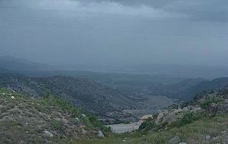
The River Jindi, also known as Kot and Manzari Baba, begins in the hills of Malakand Agency, in the northern district of Charsadda, in Khyber-Pakhtunkhwa, Pakistan. During the early months of each year, the River Jindi has a very limited water supply, but the summer months bring with them much needed rain to water the area. As the river proceeds downstream, the local people use dams, similar to the Warsak Dam on the Kabul River, to take out water for irrigation; therefore, the amount of water flowing downstream decreases. The area surrounding the Kabul and Jindi rivers is one of the largest irrigated areas within Khyber-Pakhtunkhwa.[1] This coupled with an exponentially growing population alludes to problems in the future. The River Jindi used to have enough water to sustain the surrounding area, but over the last few years, due to the environmental changes including massive droughts and rising global temperatures, the river does not. This, coupled with growing pollution of the water, is making the ability to acquire fresh clean water detrimental to the area and its surrounding population.
The river passes through other villages like Spankharo, Prang Ghar, Palay, Umerzai, Turangzai, Utmanzai and then through one of the tehsil of Charsadda Tangi, and it meets with the Swat River south of Charsadda at Baberra.
Related Research Articles
The Mohmand or Momand is Pashtun tribe. They are mostly based in the eastern districts of Nangarhar Province, Afghanistan and Mohmand District of Khyber Pakhtunkhwa, Pakistan.
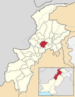
Charsadda District is a district in Peshawar Division of Khyber Pakhtunkhwa province in Pakistan. Prior to its establishment as a separate district in 1998, it was a tehsil within Peshawar District. Pashtuns make up majority of the population of the district. District headquarter is town of Charsadda, which was part of the Peshawar ex-metropolitan region.
Mardan District is a district in Mardan Division of Khyber Pakhtunkhwa province in Pakistan. The district is named after Mardan city, which is also the headquarters of the district. The district is famous for its agriculture industry, Peerah(پیڑا) the famous sooghaat of mardan and for its archaeological sites of Takht Bhai, Jamal Garhi and Sawal Dher.
Peshawar District is a district in Peshawar Division of Khyber Pakhtunkhwa province in Pakistan. It is located about 160 km west of the Pakistan's capital Islamabad. The district headquarter is Peshawar, which is also the capital of Khyber Paktunkhwa.
The Kabul River, the classical Cophen, is a 700-kilometre (430 mi) long river that emerges in Maidan Wardak Province in the Sanglakh Range of the Hindu Kush mountains in Afghanistan, and is separated from the watershed of the Helmand River by the Unai Pass. The Kabul River empties into the Indus River near Attock, Pakistan. It is the main river in eastern Afghanistan and the Khyber Pakhtunkhwa province of Pakistan.
Nowshera is the capital city of Nowshera District in the Khyber Pakhtunkhwa province of Pakistan. It is the 78th largest city in Pakistan and ninth largest city in the province of Khyber Pakhtunkhwa.
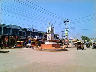
Chārsadda is a town and headquarters of Charsadda District, in the Khyber Pakhtunkhwa province of Pakistan. It is the eighty fifth-largest city of Pakistan, according to 2017 census. Located in the Valley of Peshawar, Charsadda lies about 29 kilometres (18 mi) from the provincial capital of Peshawar at an altitude of 276 metres (906 ft). The total area of Charsadda District measures about 996 square Km. The district is geographically organized into two primary parts: Hashtnagar and Do Aaba. The city hosts the ruins of what was once the ancient Gandharan capital city of Pushkalavati, and home of the Sanskrit grammarian Pāṇini.
The Swat River is a perennial river in the northern region of Khyber-Pakhtunkhwa Province, Pakistan. The river commences in the Kalam Valley of Swat Kohistan with the confluence of two main tributaries Ushu and Utrar and runs downstream in a narrow gorge up to Baghdheri.
Malakand District is a district in Malakand Division of Khyber Pakhtunkhwa province in Pakistan.
The Kūnaṛ River, also known in its upper reaches as the Mastuj, Chitral, or Kama River, is about 480 km long, located in eastern Afghanistan and northern Pakistan. It emerges just south of the Broghil Pass, in the upper part of Chitral District of Khyber Pakhtunkhwa near the Afghan border. The river system is fed by melting glaciers and snow of the Hindu Kush mountains. The Kunar River is a tributary of the Kabul River, which is in turn a tributary of the Indus River.
Kurram District is a district in Kohat Division of Khyber Pakhtunkhwa province in Pakistan. Until 2018, it was an agency of Federally Administered Tribal Areas, with merger of FATA with Khyber Pakhtunkhwa, it became a district. Geographically, it covers the Kurram Valley region which is a valley in the northwestern part of Pakistan. Most of the population is Pashtun and the main religion is Islam. Major tribes living in Kurram Agency are Bangash, Turi, Orakzai, as well as Mamozai, Muqbil, Zazai, Mangal, Ghilzai, Para Chamkani, Hazara and Khoshi tribe.
Bara River is a river in Khyber Agency and Khyber Pakhtunkhwa, Pakistan. The Bara River originates in the Tirah Valley of Bara Tehsil, Khyber Agency. It joins the Kabul River Canal which originates from the Warsak Dam, and re-enters Peshawar. Then it flows in the North-easterly direction to the Nowshera District, eventually joining the Kabul River near Camp Koruna, Akbarpura. Due to its higher elevation, very limited areas flow through gravity into Bara river.
Dheri Zardad is a town and union council of Charsadda District in Khyber Pakhtunkhwa province of Pakistan. It is located on the bank of the Kabul River at 34°2'44N 71°50'9E and has an altitude of 258 metres. It was built by Zardad Khan Popalzay Durrani, who was the governor of the then Peshawar province under the Durrani Empire; he purchased the land and the village was built as a hunting place.
Charsadda Tehsil is a tehsil located in Charsadda District, Khyber Pakhtunkhwa, Pakistan.
Nisatta also referred to as Nisaia, Nysa and Nysian is a town and union council of Charsadda District in Khyber Pakhtunkhwa province of Pakistan. It is located at 34°6'8N 71°47'47E and has an altitude of 277 metres.
Prang is a town of Charsadda District in the Khyber Pakhtunkhwa province of Pakistan. It is at 34°8'20N 71°44'11E with an altitude of 276 metres and is above the junction of the Swat and Kabul rivers, 16 miles north-east of Peshawar. It is practically the southern portion of the town of Charsadda.
Zakhi, literally meaning smart and strong, in the Nowshera district of the Khyber Pakhtunkhwa Province of Pakistan. The population is around 15,000; the majority of them work in agriculture, a small number are involved in government jobs, and some work outside the country. The villagers are 99% ethnic Pashtun tribes and 1% non-Pashtun, they speak Hindko or Persian languages.
The topography of Pakistan is divided into eight geographic areas: the northern highlands, the Indus River plain, the desert areas, the Pothohar Plateau, Balochistan Plateau, Salt Range, and the Sistan Basin. All the rivers of Pakistan, i.e. Sindh, Ravi River, Chenab River, Jhelum River, and Sutlej River, originate from the Himalayas mountain range. Some geographers designate Plateau as to the west of the imaginary southwest line; and the Indus Plain lies to the east of that line.
Mohmand Dam is an under construction multi-purpose concrete-faced rock-filled dam located on the Swat River and Panjkora River approximately 37 km north of Peshawar and 5 km upstream of Munda Headworks in Mohmand District, Khyber Pakhtunkhwa, Pakistan.
The Valley of Peshawar or Greater Peshawar is a broad valley situated in the central part of the Khyber Pakhtunkhwa province of Pakistan. The valley is 7,176 km2 (2,771 sq mi) in area, and is traversed by the Kabul River. It has a mean elevation of 345 metres (1,132 ft). The valley takes its name from the city of Peshawar, which is situated at the western part of the valley close to Warsak Dam. To the west of the valley lies the Khyber Pass. The five most populous cities in the valley are Peshawar, Mardan, Swabi, Charsadda, and Nowshera.
jendi is becoming a visiting center nowadays. There is a main bridge on this river at Jendi bazaar made during British rule on this area. There are also some fish centers on the bank of this river. The fish found in Jendi river are of strange kinds therefore, jendi is a fish hunting center for the whole district of charsadda. Local people often come in the evening and enjoy the beautiful natural scenes. Coordinates: 34°11′27″N71°44′53″E / 34.19097°N 71.74807°E / 34.19097; 71.74807
This page is based on this Wikipedia article Text is available under the CC BY-SA 4.0 license; additional terms may apply. Images, videos and audio are available under their respective licenses.