
Indio is a city in Riverside County, California, United States, in the Coachella Valley of Southern California's Colorado Desert region. Indio is approximately 125 miles (201 km) east of Los Angeles, 23 miles (37 km) east of Palm Springs, and 98 miles (158 km) west of Blythe, California.

Manipur is a landlocked state in northeast India with Imphal as its capital. It borders Assam to the west, Mizoram to the south, and Nagaland to the north. It shares international borders with Myanmar, specifically the Sagaing Region to the east and Chin State to the southeast. Covering an area of 8,621 square miles, the state consists mostly of hilly terrain with the 700-square-mile Imphal Valley inhabited by the Meitei (Manipuri) community, historically a kingdom. Surrounding hills are home to Naga and Kuki-Zo communities, who speak Tibeto-Burman languages. The official language and lingua franca, Meitei (Manipuri), also belongs to the Tibeto-Burman family.

Balti is a Tibetic language natively spoken by the ethnic Balti people in the Baltistan region of Gilgit-Baltistan, Nubra Valley of the Leh district and in the Kargil district of Ladakh, India. The language differs from Standard Tibetan; many sounds of Old Tibetan that were lost in Standard Tibetan are retained in the Balti language. It also has a simple pitch accent system only in multi-syllabic words while Standard Tibetan has a complex and distinct pitch system that includes tone contour. Due to effects of dominant languages in Pakistani media like Urdu, Punjabi and English and religious impact of Arabic and Persian languages, Balti, like other regional languages of Pakistan, is continuously expanding its vocabulary base with loanwords.

The Illawarra is a coastal region in the southeast of the Australian state of New South Wales. It is situated immediately south of Sydney and north of the South Coast region. It encompasses the two cities of Wollongong, Shellharbour and the coastal town of Kiama. Wollongong is the largest city of the Illawarra with a population of 240,000, then Shellharbour with a population of 70,000 and Kiama with a population of 10,000. These three cities have their own suburbs. Wollongong stretches from Otford in the north to Windang in the south, with Maddens Plains and Cordeaux in the west.

Donyi Polo is the designation given to the indigenous religion, of animistic and shamanic type, of the Tani and other Sino-Tibetan peoples of Arunachal Pradesh and Assam in Northeast India. The name "Donyi-Polo" means "Sun-Moon", and was chosen for the religion in the process of its revitalisation and institutionalisation started in the 1970s in response to inroads made by Christianity and the possibility of absorption into Hinduism.

Silchar is a city and the headquarters of the Cachar district of the state of Assam, India. It is second largest city of Assam after Guwahati in terms of area, population and GDP. It is also administrative capital of Barak Valley division. It is located 343 kilometres south east of Guwahati. It was founded by Captain Thomas Fisher in 1832 when he shifted the headquarters of Cachar to Janiganj in Silchar. It earned the moniker "Island of Peace" from Indira Gandhi, the then Prime Minister of India. Silchar is the site of the world's first polo club and the first competitive polo match. In 1985, an Air India flight from Kolkata to Silchar became the world's first all-women crew flight. Silchar was a tea town and Cachar club was the meeting point for tea planters.
Bomba or Bomba del Chota is an Afro-Ecuadorian music and dance form from the Chota Valley area of Ecuador in the province of Imbabura and Carchi. Its origins can be traced back to Africa via the middle passage and the use of African slave labor during the country's colonial period. Africans brought to labor as slaves in Ecuador brought with them this music form heavily influenced from the Bantu cultures of the Congo. The people dance in pairs to the drums and use improvisation to build relationships between the dancer and lead drummer.

The Trans-Karakoram Tract, also known as the Shaksgam Tract, is an area of approximately 5,200 km2 (2,000 sq mi) north of the Karakoram watershed, including the Shaksgam valley. The tract is administered by China as part of its Taxkorgan and Yecheng counties in the Xinjiang Uyghur Autonomous Region. Although the Shaksgam tract was originally under the control of India following the accession of Jammu and Kashmir to India in 1947, Pakistan took control of the region after the First India-Pakistan War and subsequently ceded it to China in 1963 through the Sino-Pakistan Agreement, and a border based on actual ground positions was recognized as the international border by China and Pakistan. The Shaksgam Tract, along with the entire Kashmir region, is claimed by India. Further, New Delhi has never accepted the China-Pakistan boundary pact, asserting that Islamabad "unlawfully" attempted to cede the area to Beijing.

Shandur Pass(Urdu: شندور) is a pass located on the boundary of district Chitral, Khyber Pakhtunkhwa, Pakistan and Gilgit-Baltistan, a disputed territory within the larger region of Kashmir. Historically part of Gilgit-Baltistan; however, recent Khyber Pakhtunkhwa governments have made claims for the Shandur. It is often referred to as 'The Roof of the World.

The Astore Valley is a valley located in the Astore District of Gilgit-Baltistan region in Pakistan.
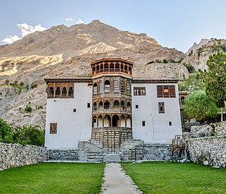
Khaplu, also spelt Khapalu, is a city that serves as the administrative capital of the Ghanche District in Pakistan-administered Gilgit-Baltistan, within the disputed Kashmir region. Located 103 km (64 mi) east of Skardu, Khaplu was historically the second-largest kingdom in Baltistan under the Yabgo dynasty and played a key role in guarding the trade route to Ladakh along the Shyok River, near its confluence with the Indus.

The Kho, or Chitrali people, are an Indo-Aryan ethnolinguistic group native to the Chitral District in Khyber Pakhtunkhwa, Pakistan and the Gupis-Yasin and Ghizer districts of Gilgit-Baltistan. They speak an Indo-Aryan language called Khowar.

Gilgit-Baltistan, formerly known as the Northern Areas, is a region administered by Pakistan as an administrative territory and consists of the northern portion of the larger Kashmir region, which has been the subject of a dispute between India and Pakistan since 1947 and between India and China since 1959. It borders Azad Kashmir to the south, the province of Khyber Pakhtunkhwa to the west, the Wakhan Corridor of Afghanistan to the north, the Xinjiang region of China to the east and northeast, and the Indian-administered union territories of Jammu and Kashmir and Ladakh to the southeast.

Rondu District, also spelled Roundu District, is a district of Pakistan-administered Gilgit-Baltistan in the disputed Kashmir region. It is one of 14 districts of Gilgit-Balistan. The district encompasses the entire Roundu Valley, which is the fourth-largest valley in Gilgit-Baltistan, after the Skardu, Khaplu, and Shigar valleys. The Roundu valley lies in the western part of the Baltistan Division and forms the main trade and travel route between the Baltistan Division and the Gilgit Division. The Rondu District was carved out of Skardu District in 2019.

Kutiah Lungma Glacier is a glacier that stretches for approximately 12 km in length and has a width of about 3 km. It is situated within the Karakoram mountain range in the Stak Valley of District Skardu, Gilgit-Baltistan, Pakistan. This glacier is located in the Stak Valley, which is sometimes referred to as Staq, and it falls within the subdivision of Roundu in district Skardu, Gilgit-Baltistan.
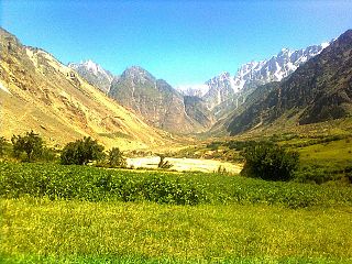
Stak Valley is a valley in the Roundu Subdivision of District Skardu, in the Gilgit-Balitistan territory of Pakistan. The valley is on the right bank of the Indus River, between the cities of Skardu and Giligit. The valley is the biggest valley in term of area and population in Roundu subdivision. The valley has been one of the very important regions of the area in term of in history and of geological formation as well.
Thowar Valley is located in the Roundu Subdivision of Skardu District within Pakistan-administered Gilgit-Baltistan, part of the disputed Kashmir region. Positioned on the right bank of the Indus River, Pakistan's longest river, the valley lies between Skardu and Gilgit city. Serving as the administrative hub of Roundu Subdivision, Shower Valley houses key facilities, including the THQ hospital, Assistant Commissioner's House, a college and other significant landmarks.

Pakke-Kessang is a district located in the state of Arunachal Pradesh in the Northeast of India. The district used to be a part of the neighboring district, East Kameng, and has been created out of its five southernmost administrative units: Pijerang, Passa Valley, Pakke-Kessang, Dissing Passo and Seijosa. The district headquarters of Pakke-Kessang is located at Lemmi.

Trespone is a scenic village in the TSG block of Sankoo tehsil in the Kargil district of the Indian union territory of Ladakh. Trespone is a historically, culturally, and architecturally rich village in the Suru Valley, located on the bank of the Suru River, and is around 20 km from Kargil town. It is often called little Kashmir, and is the gateway to Suru Valley. It is surrounded by five other villages, namely Saliskote, G.M.Pore, Tambis, Kanoor and Sarchey.
