
Baltistan, also known as Baltiyul or Little Tibet, is a mountainous region in the Gilgit-Baltistan portion of Pakistan-administered Kashmir. It is located near the Karakoram mountains just south of K2, and borders Gilgit to the west, China's Xinjiang to the north, Ladakh to the southeast, and the Kashmir Valley to the southwest. Its average altitude is over 3,350 metres (10,990 ft). The modern administrative region is the Baltistan Division.

Gilgit is the capital city of Gilgit–Baltistan, Pakistan. The city is located in a broad valley near the confluence of the Gilgit River and Hunza River, and is a major tourist destination in Pakistan, serving as a hub for trekking and mountaineering expeditions in the Karakoram mountain range.

The Karakoram Highway is a 1,300 km (810 mi) national highway which extends from Hasan Abdal in the Punjab province of Pakistan to the Khunjerab Pass in Gilgit-Baltistan, where it crosses into China and becomes China National Highway 314. The highway connects the Pakistani provinces of Punjab and Khyber Pakhtunkhwa plus Gilgit-Baltistan with China's Xinjiang Uyghur Autonomous Region. The highway is a popular tourist attraction and is one of the highest paved roads in the world, passing through the Karakoram mountain range, at 36°51′00″N75°25′40″E at maximum elevation of 4,714 m (15,466 ft) near Khunjerab Pass. Due to its high elevation and the difficult conditions under which it was constructed, it is often referred to as the Eighth Wonder of the World. The highway is also a part of the Asian Highway AH4.

Skardu is a city located in Gilgit−Baltistan, Pakistan, and serves as the capital of the Skardu District. Skardu is situated at an elevation of nearly 2,500 metres in the Skardu Valley, at the confluence of the Indus and Shigar Rivers. The city is an important gateway to the eight-thousanders of the nearby Karakoram mountain range. The Indus River running through the region separates the Karakoram from the Himalayas.

Kargil is a city and a joint capital of the union territory of Ladakh in India. It is also the headquarters of the Kargil district. It is the second-largest city in Ladakh after Leh. Kargil is located 204 kilometres (127 mi) to the east of Srinagar in Jammu and Kashmir, and 234 kilometres (145 mi) to the west of Leh. It is the centre point of the Suru River.

Astore District is one of the 14 districts of the Pakistani-administered territory of Gilgit−Baltistan. Its administrative headquarters are located at Eidgah in the Astore Valley. The Astore District is bounded by Gilgit District to the north, Roundu District to the northeast, Skardu District to the east, Kharmang District to the southeast, Diamer District to the west, the Neelum District of Azad Jammu and Kashmir to the southwest, and the Bandipore District of Indian-administered Jammu and Kashmir to the south.

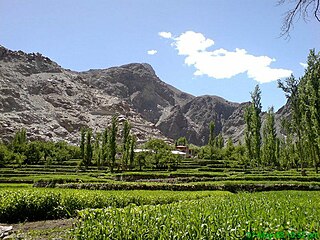
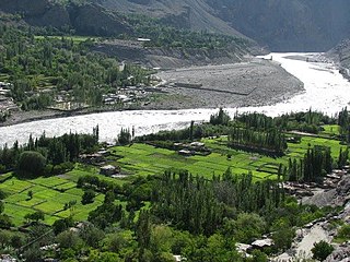
The Shigar Valley is a valley in Gilgit Baltistan in northern Pakistan that is watered by the Shigar River, and centred on the town of Shigar. The valley stretches about 170 km from Skardu to Askole and is the gateway to the high mountains of the Karakoram. The town of Shigar is the largest settlement in valley. Even though the Shigar Valley is a remote and largely inaccessible place, there are several villages in the valley. Askole is the last settlement in the Shigar Valley, which is still far from the high mountains. Shigar was an administrative sub-division of Skardu District that is now a district in its own right.

Gilgit-Baltistan has been under Pakistan administration since 1947 and was given self-governing status on August 29, 2009. Gilgit-Baltistan comprises 10 districts within three divisions. The four districts of Skardu Kharmang Shigar and Ghanche are in the Baltistan Division, four districts of Gilgit Ghizer Hunza and Nagar districts which were carved out of Gilgit District are in the Gilgit Division and the third division is Diamir, comprising Chilas and Astore. The main political centres are the towns of Gilgit and Skardu.

The Shingo River is a tributary of the Indus River, and flows through Gilgit-Baltistan and Kargil regions.
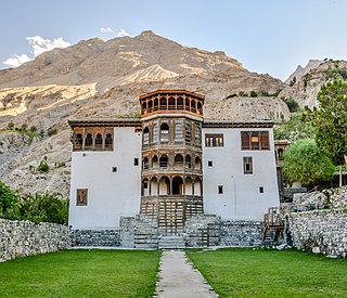
Khaplu, also spelt Khapalu, is a city that serves as the administrative capital of the Ghanche District of Gilgit-Baltistan, in northern Pakistan. Lying 103 km (64 mi) east of the city of Skardu, it was the second-largest kingdom in old Baltistan of the Yabgo dynasty. It guarded the trade route to Ladakh along the Shyok River east of its confluence with the Indus.

The Skardu Valley is located in Gilgit-Baltistan, Pakistan. The valley is about 10 km wide and 40 km long. It is at the confluence of the Shigar River and Indus River. It surrounded by the large Karakoram Range. With the nearby lakes and mountains, it is an important tourist location in Pakistan. Skardu is the main town of Baltistan along the wide bank of the river Indus. Skardu is the largest district of the Northern Areas. Baltistan is home to some of the highest peaks in the world, the Karakoram Range, Skardu is very popular with Mountaineering Expeditions. It is equally popular with high altitude trekkers, who treks to Baltoro Glacier, K2 Base Camp and Concordia. Skardu by road, lies approximately 5 hours away from Gilgit and 10 hours drive from Besham.

Gilgit-Baltistan, formerly known as the Northern Areas, is a region administered by Pakistan as an administrative territory, and constitutes the northern portion of the larger Kashmir region, which has been the subject of a dispute between India and Pakistan since 1947, and between India and China since 1950s. It is the northernmost area administered by Pakistan. It borders Pakistan-administered Azad Kashmir to the south, the Pakistani province of Khyber Pakhtunkhwa to the west, the Wakhan Corridor of Afghanistan to the north, the Xinjiang region of China, to the east and northeast, and the Indian-administered union territories Jammu and Kashmir and Ladakh to the southeast.
Juglot or Jaglot is a town located in the Gilgit District of Gilgit−Baltistan, Pakistan. It is situated 45 kilometres (28 mi) southeast of the capital city of Gilgit on the Karakoram Highway. The town is situated at the junction of three major mountain ranges: the Karakoram, the Hindu Kush and the Himalayas. Juglot is also the junction where the roads to Gilgit and Skardu split into different directions; the road to Skardu branches off by about six kilometres towards Gilgit.

Hassanabad is a village in Sub-Division Chorbat, Ghangche District of Gilgit-Baltistan, Pakistan, lying 141 kilometres (88 mi) east of Skardu, near the border of India.
Tolti is a city that serves as the administrative capital of Kharmang District, Gilgit Baltistan, Pakistan. It means "Little Tibet". The village lies on the left bank of the Indus, and is approximately 35 km south-east of the confluence of the Indus from the Shayok. It is today by a well-paved road that runs along the left bank of the Indus slightly from Skardu to reach out.

Tourism in Gilgit-Baltistan, an administrative unit of Pakistan, focuses on the mountains. Gilgit-Baltistan borders Pakistan's Khyber Pakhtunkhwa Province to the west, a small portion of the Wakhan Corridor of Afghanistan to the north, Xinjiang, China to the northeast, the Indian territory Jammu and Kashmir and Ladakh to the southeast, and the Pakistani-administered state of Azad Kashmir to the south.

Kutiah Lungma Glacier is a 12 km long and 3 km wide glacier in Karakorum mountain ranges in Stak Valley of District Skardu, Gilgit-Baltistan, Pakistan. It is located in a valley, Stak Valley, which is in the subdivision Roundu of district Skardu Gilgit-Baltistan. The glacier is in the north of Nanga Parbat, about 20 kilometers away from the northern bank of the Indus River. One can access the glacier from June–September from Skardu or Gilgit city, as it is about 10 km away from the Gilgit-Skardu road. An un-metalled road from Gilgit-Skardu Road at the junction of Indus River and Stak Valley stream leads to the base camp of the glacier.
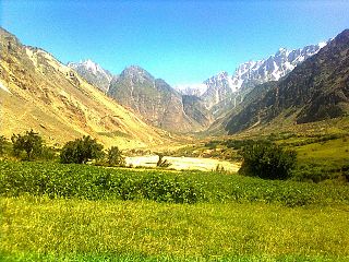
Stak Valley is a valley in the Roundu Subdivision of District Skardu, Gilgit-Balitistan, Pakistan. The valley is on the right bank of the Indus River, Pakistan's longest river, between Skardu and Giligit city. The valley is the biggest valley in term of area and population in Roundu subdivision. The valley has been one of the very important regions of the area in term of in history and of geological formation as well.
Siksa is a village in the Chorbat Valley, Ghanche District of Gilgit-Baltistan, Pakistan, lying 150 kilometres (93 mi) east of Skardu, near the border of Pakistan and India at an elevation of 2,725 metres (8,940 ft).

