Nagar Valley

Last updated

Nagar Valley
Rakaposhi, Nagar GB (Pakistan).jpg
The 7,788 m (25,551 ft) tall Rakaposhi as seen from the Hunza Valley
Pakistan location map.svg
Red pog.svg
Nagar Valley
Location in Pakistan
Coordinates: 36°15′55″N74°42′49″E / 36.2652548°N 74.7135025°E / 36.2652548; 74.7135025 [1]
Country Pakistan
Region Gilgit Baltistan
District Nagar District
Official Logo of NAGAR STATE Nagar State Flag.png
Official Logo of NAGAR STATE

Nagar Valley [2] once a princely state, now stands as one of the ten districts within the Gilgit-Baltistan region of Pakistan. [3] [4] [5] This valley is situated along the renowned Karakoram Highway, as one travels northward from the city of Gilgit. The valley is home to many high mountain peaks including Rakaposhi (7788m), Diran Peak (7265m), Golden Peak and Rush Peak.

Contents

The Nagar valley is administratively divided into two tehsils: Nagar-I and Nagar-II. [6] All the villages of upper Nagar including Shayar, Askurdas, Sumayar, Nagarkhas, Hoper Valley, and Hispar come under Nagar-I, whereas the villages of lower Nagar including Chalt Paeen, Chalt Bala, Sonikot, Akbarabad, Rabat, Bar, Buddalas, Chaprote, Skandarabad, Jafarabad, Nilt, Thol, Ghulmet, Pisan, Minapin, Meacher, Dadhimal, Phekar, and Hakuchar are part of Nagar-II. Burushaski and Shina languages are predominantly spoken in the valley. [3]

The Rush Lake, the highest alpine lake of Pakistan and the 27th highest lake in the world, also lies in this valley. [7]

Geography

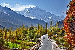
The topography of the Nagar Valley is characterized by hills and mountains, making it a mountainous region overall. However, the valley's terrain is such that all parts of it are readily accessible. The Karakoram mountain range envelope the entire region, including the Rakaposhi peak. Of the total area of the Nagar valley, 90% is above 3,000 meters above sea level and 30% is 5,000 meters above sea level. [8]

History

Nilt forts, Nagar Nilt forts.jpg
Nilt forts, Nagar

Nagar was an independent principality for more than 1,200 years. The British gained control of Nagar during the Anglo-Brusho war, locally known as Jangir-e-Lae. Jangir-e-Lae was fought between the people of Nagar state and the troops of the British Raj at Nilt from 1 to 23 December 1891. [9]

The British troops faced intense resistance from the people of Nagar under the leadership of the Tham (Chief) of that time, Azur Khan, at the Nilt Nallah (known as Jamila Mo Har). [10] The people of Nagar fought bravely for more than 20 days but were defeated due to a lack of armaments. Over 100 Nagar lost their lives and 127 were imprisoned. On the British side, four British officers and over 50 Dogra levies lost their lives. [9] The British retained Nagar's status as a principality. [11] Even after the revolt against the Maharaja of Kashmir and unconditional accession to Pakistan in 1948, Nagar's status continued to be that of a princely state.

During the 1960s, people start protesting against the despotism of the Mir, demanding the abolition of Begar and reduction in taxation. In 1970, they organized a march to Gilgit to register their demands authorities, while Gilgit sent scouts against the people. The scouts opened fire on the demonstrators in Chalt, killing nine people and wounding many more. The leaders of the protest were imprisoned. [2] Later, on 25 September 1974, Prime Minister of Pakistan Zulfiqar Ali Bhutto dissolved the princely states of Nagar and Hunza, set the prisoners free and gave democratic representation to the Northern Areas Council, now the Gilgit-Baltistan Legislative Assembly. [12]

Tourist attractions

Rakaposhi, Ghulmet Nagar Rakaposhi & Autumn.jpg
Rakaposhi, Ghulmet Nagar
Golden Peak, Hispar Nagar Spantik Sud-West-Grat.JPG
Golden Peak, Hispar Nagar
Bar Ter Nagar valley Bar ter nagar valley.jpg
Bar Ter Nagar valley
Rush Lake, Hoper Valley Nagar Rush lake.JPG
Rush Lake, Hoper Valley Nagar
Snow Lake, Hispar Nagar Snow Lake Pakistan.jpg
Snow Lake, Hispar Nagar

Famous Spots

Meadows and pastures

Nagar is home to many famous high altitude meadows such as:

Mountain peaks

Famous peaks in the region are:

Lakes

Famous alpine Lakes in the region are:

Glaciers

Famous glaciers in the region are:

Mountain passes

Famous passes in the region are:

Mines and Minerals

Nagar is considered to be one of the gemstone-rich valleys of Gilgit-Baltistan. It contains numerous mining sites that yield a range of precious and semiprecious gemstones.

Mining Sites

Minerals

Aquamarine is precious gemstones found in Chumar Bakhoor area of Sumayar and adjoining mountains of Phekar Nagar.

Fluorite is precious gemstones found in Chumar Bakhoor area of Summayar Nagar.

Apatite is rear and precious gemstone found in Chumar Bakhoor along with Aquamarine and Fluorite summayar nagar.

Jet deposits are found in various areas of Nagar District such as, Minapin, Chalt and Nagar Khas.

Marble deposits are found in Pisan, Minapin, Nagar Khas and Sumayar regions of Nagar.

See also

Related Research Articles

<span class="mw-page-title-main">Rakaposhi</span> Mountain in Pakistan

Rakaposhi also known as Dumani is a mountain within the Karakoram range. It is situated in the middle of the Nagar Valley and the Bagrote Valley, which is part of the Gilgit-Baltistan territory in Pakistan. The mountain is extremely broad, measuring almost 20km from east to west. It is the only peak on earth that descends directly and without interruption for almost 6,000 meters from its summit to its base.

<span class="mw-page-title-main">Karakoram Highway</span> International highway running through Pakistan and China

The Karakoram Highway is a 1,300 km (810 mi) national highway which extends from Hasan Abdal in the Punjab province of Pakistan to the Khunjerab Pass in Gilgit-Baltistan, where it crosses into China and becomes China National Highway 314. The highway connects the Pakistani provinces of Punjab and Khyber Pakhtunkhwa plus Gilgit-Baltistan with China's Xinjiang Uyghur Autonomous Region. The highway is a popular tourist attraction and is one of the highest paved roads in the world, passing through the Karakoram mountain range, at 36°51′00″N75°25′40″E at maximum elevation of 4,714 m (15,466 ft) near Khunjerab Pass. Due to its high elevation and the difficult conditions under which it was constructed, it is often referred to as the Eighth Wonder of the World. The highway is also a part of the Asian Highway AH4.

<span class="mw-page-title-main">Kunyang Chhish</span> Mountain in India

Kunyang Chhish or Kunyang Chhish is the second-highest mountain in the Hispar Muztagh, a subrange in the Karakoram mountains in Pakistan. An alternate variation of the name is Kunyang Kish. Its height, also sometimes given as 7,823 metres (25,666 ft), is ranked 21st in the world.

<span class="mw-page-title-main">Nagar (princely state)</span> Princely state of the British Raj and Pakistan

Nagar was a princely state located in the northern region of Gilgit–Baltistan, Pakistan. Before August 1947, it maintained a subsidiary alliance with British India. It shared its borders with the Gilgit Agency states to the south and west, while to the north and east, it bordered the princely state of District Hunza. From November 1947 to 1974, Nagar was recognized as a princely state within Pakistan, with its administrative center in the town of Nagar.

<span class="mw-page-title-main">Hunza Valley</span> Valley in Gilgit-Baltistan, Pakistan

The Hunza Valley is a mountainous valley in the northern part of the Gilgit-Baltistan region of Pakistan.

<span class="mw-page-title-main">Rakaposhi-Haramosh Mountains</span> Subrange of the Karakoram mountain range

The Rakaposhi-Haramosh Mountains are a subrange of the Karakoram range. They are located in the Bagrot Valley Gilgit and Nagar Districts, in the Gilgit-Baltistan of Pakistan.

<span class="mw-page-title-main">Nagarkhas</span> Place in Gilgit–Baltistan, Pakistan

Nagarkhas, also known as Oyum-Nagar, serves as the administrative center for the Nagar District in Gilgit–Baltistan region of Pakistan and is one of the main towns of the district. Located along the Nagar River, this town also held the distinction of being the capital of the erstwhile princely state of Nagar.

<span class="mw-page-title-main">Geography of Gilgit-Baltistan</span>

Gilgit-Baltistan is an administrative territory of Pakistan in the northern part of the country. It was given self-governing status on August 29, 2009. Gilgit-Baltistan comprises 14 districts within three divisions. The four districts of Skardu Kharmang Shigar and Ghanche are in the Baltistan Division, four districts of Gilgit Ghizer Hunza and Nagar districts which were carved out of Gilgit District are in the Gilgit Division and the third division is Diamir, comprising Chilas and Astore. The main political centres are the towns of Gilgit and Skardu.

<span class="mw-page-title-main">Miar Peak</span>

Miar Peak is a mountain in Hispar Valley in the Nagar Valley and Bagrot Valley of Gilgit-Baltistan, Pakistan. It lies southeast of Diran peak and northwest of Malubiting peak.

<span class="mw-page-title-main">Hopar Valley</span> Place in Pakistan

The Hopper Valley is a section of the Nagar Valley in Gilgit-Baltistan, Pakistan. It's situated approximately 10 km from Nagar Khas, the main city of the Nagar Valley. The Hopper Valley is known for the Spantik and Hopper glaciers.

<span class="mw-page-title-main">Hispar Valley</span> Valley in Gilgit Baltistan, Pakistan

The Hispar Valley (also spelled Hisper valley", situated in Gilgit-Baltistan, Pakistan, is the final valley in the Nagar region. It's located approximately two kilometers downstream from the 49-kilometer-long Hispar Glacier. The valley is roughly 28 km from Nagar Khas and 25 km from Hopper Valley. It is accessible via a road leading from the Karakoram Highway towards the Nagar and the Hopar Valley. The Hispar/Hisper Valley serves as a vital link between the Nagar District and the Shigar District, connected by the Hispar Pass at an elevation of 16,824 ft.

<span class="mw-page-title-main">Bagrot Valley</span> Place in Gilgit-Baltistan, Pakistan

Bagrote Valley is a valley in the Karakoram Mountain range in the Gilgit–Baltistan region of northern Pakistan. River Bagrote flows through the valley from the north to the southwest, supplying water to the settlements of Jalalabad and Oshikhandass before merging with the Gilgit River.

<span class="mw-page-title-main">Hunza–Nagar Campaign</span> 1891 British military campaign

The Hunza-Nagar Campaign was fought in 1891 by troops serving as military personnel of the British Raj against the princely states of Hunza and Nagar in the Gilgit Agency. It is also known in Pakistan as the Anglo-Brusho War or Jangir-e-Lae.

<span class="mw-page-title-main">Nagar District</span> District of Gilgit-Baltistan administered by Pakistan

Nagar District is a district of Pakistan's Gilgit-Baltistan area in the disputed Kashmir region. It is one of the 14 districts of Gilgit-Baltistan. Nagar District was established in 2015 by the division of the Hunza–Nagar District into two districts: the Hunza District and the Nagar District. The Nagar District is bounded on the north and north-east by the Hunza District, on the south-east by the Shigar District, on the south by the Gilgit District, and on the west by the Gupis-Yasin District. The district headquarters in the town of Nagarkhas.

<span class="mw-page-title-main">Tourism in Gilgit-Baltistan</span> Overview of the tourism industry in Gilgit-Baltistan, Pakistan

Tourism in Gilgit-Baltistan, an administered territory of Pakistan, focuses on its access to various mountain ranges and alpine terrain.

Chumar Bakor is a gemstone mining area located at an elevation of 5,520 meters in the Sumayar Valley of Nagar District, Gilgit-Baltistan, Pakistan. Geographically it is also closer to the Oyum-Nagar (Nagarkhas). Walking from central Sumayar, it takes around 4 to 5 hours to reach the pegmatites that crop out on the western side of the mountain above 4000 meters elevation. Appiani (2007) states that according to the gemstone deposits at Chumar Bakor were first discovered in 1984 by local hunter Muhammad Shah. Chumar Bakor contains various precious and semi-precious gemstones such as Aquamarine, Fluorite, Apatite, Calcite, and Quartz.

<span class="mw-page-title-main">Sumayar</span> River valley in Pakistan

Sumayar is a small valley situated within the Nagar District of Gilgit-Baltistan, Pakistan. The valley is located at the confluence of the Hunza River and the Nagar River in Pakistan. It is bounded by eroded landscape to the north-east and mountain ridges to the south. Moreover, the valley is composed of nine small villages: Khai, Futhkhai, Yal, Boshat, Rashfari, Resman, Daltho, Thopkhan, and Jotorkhan.

Kacheli Lake is a high altitude lake located in Kacheli Meadows in Miacher Valley of Nagar District, Gilgit-Baltistan, Pakistan. Climbing Steeply from the Miachar Daman-e-Koh basecamp, It takes about two hours to reach Kacheli lake.

Gappa Valley is a tourist spot in the Nagar District, Gilgit-Baltistan, Pakistan. Gappa valley has natural jungles, fountain, grasslands, and a view of Rakaposhi. The best route to visit Gappa Valley is through Chahlat Bala. From the main Karakoram Highway, It takes close to one and half hours to reach Gappa valley via Chalt.

References

  1. "Nagar on map". Google Maps . Retrieved 15 September 2019.
  2. 1 2 Martin, Sokefeld (2005). "From Colonialism to Postcolonial Colonialism: Changing Modes of Domination in the Northern Areas of Pakistan". The Journal of Asian Studies. 64 (4): 939–973. doi:10.1017/S0021911805002287. JSTOR   25075905. S2CID   161647755.
  3. 1 2 "Nagar Valley". visitgilgitbaltistan.gov.pk. Retrieved 15 September 2019.
  4. "Dividing governance: Three new districts notified in G-B". The Express Tribune. 25 July 2015. Retrieved 17 February 2023.
  5. "Nagar Valley, Gilgit Baltistan, Pakistan". myadventure.pk. Retrieved 7 November 2018.
  6. "Geography & Demography of Gilgit-Baltistan". Gilgit-Baltistan Scouts . Retrieved 21 April 2022.
  7. "27th highest peak".
  8. Spies, Michael (2019). Northern Pakistan: High Mountain Farming and Changing Socionatures. Lahore Pakistan: Vanguard books. p. 63. ISBN   9789694026091.
  9. 1 2 Syed, Yahya. Broshaal Ke Qabail. Gilgit: North News Agency.
  10. Zulfiqar Ali, Khan; Farman Karim, Baig. "128th Anniversary of the Anglo-Burusho War". PAMIR TIMES. Retrieved 24 December 2020.
  11. Masud, Khan. "Anglo-Brusho War Of 1891". Daily Times.
  12. Ahmad, Sajjad (1 November 2020). "HISTORY: THE GILGIT-BALTISTAN CONUNDRUM". DAWN.COM. Retrieved 21 April 2022.

General