
The Karakoram is a mountain range in the Kashmir region spanning the border of Pakistan, China, and India, with the northwestern extremity of the range extending to Afghanistan and Tajikistan. Most of the Karakoram mountain range falls under the jurisdiction of Gilgit-Baltistan, which is controlled by Pakistan. Its highest peak, K2, is located in Gilgit-Baltistan, Pakistan. It begins in the Wakhan Corridor (Afghanistan) in the west, encompasses the majority of Gilgit-Baltistan, Pakistan and extends into Ladakh and Aksai Chin.

Hispar Muztagh is a sub-range of the Karakoram mountain range. It is located in the Nagar District of Gilgit-Baltistan, Pakistan, north of Hispar Glacier, south of Shimshal Valley, and east of the Hunza Valley. It is the second highest sub-range of the Karakoram, the highest being the Baltoro Muztagh. The highest mountain in the range is Distaghil Sar (7,885m/25,869 ft).
The Baltoro Glacier is a glacier located in the Shigar District of the Gilgit-Baltistan region in Pakistan. It stretches for 63 km (39 mi) in length. It is one of the longest glaciers outside the polar regions. It is home to some of the world’s highest mountains. It runs through the Karakoram mountain range, close to K2, which is the second highest peak in the world, reaching an elevation of 8,611 meters. Within a 20-kilometer radius, there are three more mountains with elevations exceeding 8,000 meters.

Kunyang Chhish is the second-highest mountain in the Hispar Muztagh, a subrange in the Karakoram mountains in Pakistan. An alternate variations of the name are Kunyang Kish and Khinyang Chhish. Its height, also sometimes given as 7,823 metres (25,666 ft), is ranked 21st in the world.
The Panmah Muztagh is a subrange of the Karakoram range, in Shigar, a district of Gilgit-Baltistan, Pakistan.

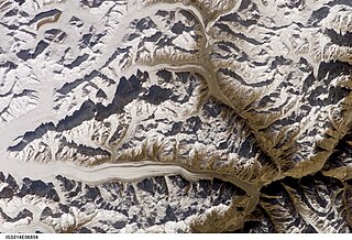
The Biafo Glacier Urdu: بیافو گلیشیر) is a glacier located within the Karakoram mountain range in the Hisper valley, Nagar District of Gilgit-Baltistan, Pakistan. It extends over a considerable distance, measuring 67 kilometers in length, and ranks as one of the largest glaciers in the entire Karakoram range. Flowing in a south-eastern direction from the central Karakoram crest, this glacier covers a basin area spanning 853 square kilometers, of which 628 square kilometers are characterized by permanent snow and ice. The accumulation zone alone contributes to 68% of the glacier's total area.
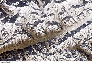
Hispar Glacier is a 49-km (30-mile) long glacier situated in the Karakoram Mountains of Gilgit–Baltistan, Pakistan. It converges with the Biafo Glacier, which extends for 67 kilometers, at the Hispar La (Pass), reaching an altitude of 5,128 meters. This confluence creates the world's longest glacial system outside of the polar regions.

The Saltoro Mountains form a subrange within the Karakoram Range and are situated in the southeastern part of the Karakoram. They lie on the southwest side of the Siachen Glacier, which is one of the two longest glaciers in the world outside the polar regions. The name "Saltoro" is also associated with the Saltoro Valley, located west of this range and descending on the Pakistani side of the Saltoro Range, which generally follows the Actual Ground Position Line (AGPL).

Nagarkhas, also known as Oyum-Nagar, serves as the administrative center for the Nagar District in Gilgit–Baltistan region of Pakistan and is one of the main towns of the district. Located along the Nagar River, this town also held the distinction of being the capital of the erstwhile princely state of Nagar.

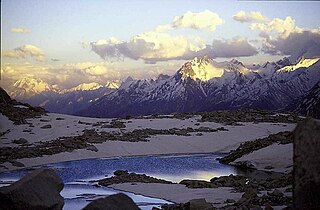
Nagar Valley once a princely state, now stands as one of the ten districts within the Gilgit-Baltistan region of Pakistan. This valley is situated along the renowned Karakoram Highway, as one travels northward from the city of Gilgit. The valley is home to many high mountain peaks including Rakaposhi (7788m), Diran Peak (7265m), Golden Peak and Rush Peak.
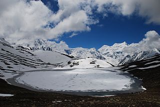
Rush Lake is a high-altitude lake located in Nagar Valley, Gilgit-Baltistan, Pakistan near Rush Peak. At 4,694 metres (15,400 ft), Rush is one of the highest alpine lakes in the world. It is located about 15 km (9 mi) north of Miar Peak and Spantik in the Nagar Valley. It is one of the highest lakes in Pakistan and the 27th-highest lake in the world.
The Hispar River forms from the melt water of the Hispar Glacier - a 49 kilometer-long glacier in the Karakoram mountains of Gilgit-Baltistan, Pakistan. The Hispar Glacier and river both flow northwest, passing through Hispar, Hopar and Nagar (Nagir) villages until the confluence with the Hunza River in the Hunza Valley. Road conditions are spectacular at best, treacherous at worst. In August 2006, a bridge below Hispar village was condemned, and the Hunza River washed the road away at the confluence, eliminating all vehicular access to the entire valley for some months.

Gilgit-Baltistan is an administrative territory of Pakistan in the northern part of the country. It was given self-governing status on August 29, 2009. Gilgit-Baltistan comprises 14 districts within three divisions. The four districts of Skardu Kharmang Shigar and Ghanche are in the Baltistan Division, four districts of Gilgit Ghizer Hunza and Nagar districts which were carved out of Gilgit District are in the Gilgit Division and the third division is Diamir, comprising Chilas and Astore. The main political centres are the towns of Gilgit and Skardu.
The Spantik-Sosbun Mountains are a sub range of the Karakoram range in Gilgit-Baltistan, Pakistan.
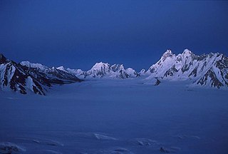
Snow Lake or Lukpe Lawo is a high-altitude glacial basin in the Karakoram mountain range in the Gilgit-Baltistan region of northern Pakistan. It is not a lake, despite its name.
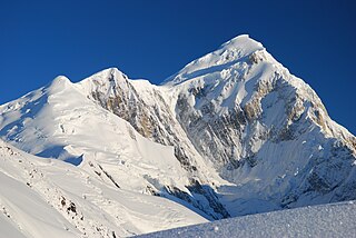
Spantik, or Golden Peak, is a mountain situated in the subrange within the Karakoram range. It is located in the Hopar Valley, Nagar District, within the Gilgit-Baltistan region of Pakistan. The northwest face of Spantik / Golden peak is renowned for its exceptionally challenging climbing route, famously referred to as the "Golden Pillar."

Hispar Pass or Hispar La is a high-altitude, non-technical mountain pass in the Karakoram Range in Nagar District, Pakistan.
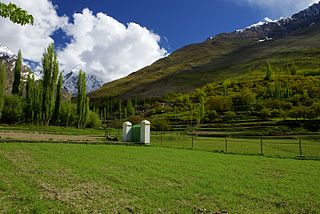
The Hopper Valley, also spelled Hopar Valley, is a section of the Nagar Valley in Gilgit-Baltistan, Pakistan. It is situated approximately 10 km from Nagar Khas, the main city of the Nagar Valley. Hopper Valley is known for the Spantik and Hopper glaciers.

Tourism in Gilgit-Baltistan, an administered territory of Pakistan, focuses on its access to various mountain ranges and alpine terrain. Various tourist destinations attract millions of travelers from within Pakistan. On the other hand, tourists from other countries also routinely visit GB. An estimated 1.72 million tourists visited the region in 2017 according to the Pakistan Tourism Development Corporation (PTDC). Travelers had contributed Rs.300 million to the local economy in 2017. The authorities were expecting 2.5 million tourists in 2018 which would have meant an additional Rs.450 million to the economy.

