
The Indus is a transboundary river of Asia and a trans-Himalayan river of South and Central Asia. The 3,180 km (1,980 mi) river rises in mountain springs northeast of Mount Kailash in Western Tibet, flows northwest through the disputed region of Kashmir, bends sharply to the left after the Nanga Parbat massif, and flows south-by-southwest through Pakistan, before emptying into the Arabian Sea near the port city of Karachi.

The St. Johns River is the longest river in the U.S. state of Florida and it is the most significant one for commercial and recreational use. At 310 miles (500 km) long, it flows north and winds through or borders twelve counties. The drop in elevation from headwaters to mouth is less than 30 feet (9 m); like most Florida waterways, the St. Johns has a very slow flow speed of 0.3 mph (0.13 m/s), and is often described as "lazy".

The Jhelum River is a river in the northern Indian subcontinent. It originates at Verinag and flows through the Indian-administered territory of Jammu and Kashmir, into Pakistan-administered Azad Kashmir, then the Pakistani province of Punjab. It is the westernmost of the five rivers of the Punjab region, and flows through the Kashmir Valley. It is a tributary of the Chenab River and has a total length of about 725 kilometres (450 mi).

Lake Manchar, also spelled Manchhar, is the largest natural freshwater lake in Pakistan, and is one of South Asia's largest. It is located west of the Indus River, in Jamshoro and Dadu districts of Sindh - 18 km away from Sehwan Sharif. Lake Manchar collects water from numerous small streams in the Kirthar Mountains, and then empties into the Indus River. The lake's surface area fluctuates with the seasons, from as little as 36 km2, to as much as 500 km2 during monsoon rains.
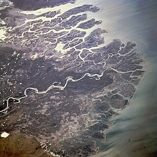
The Indus River Delta forms where the Indus River flows into the Arabian Sea, mostly in the southern Sindh province of Pakistan with a small portion in the Kutch Region of India. The delta covers an area of about 41,440 km2 (16,000 sq mi), and is approximately 210 km (130 mi) across where it meets the sea. The active part of the delta is 6,000 km2 in area (2,300 sq mi). The climate is arid, the region only receives between 25 and 50 centimetres of rainfall in a normal year. The delta is home to the largest arid mangrove forests in the world, as well as many birds, fish and the Indus dolphin.

Haleji Lake is a perennial freshwater lake in Thatta District of Sindh Province, Pakistan. It is 6.58 km2 (2.54 sq mi) in size and is surrounded by marshes and brackish seepage lagoons.

Qambar Shahdadkot District is a district of Sindh, Pakistan, originally named after Shahdad Khan Khuhawar the official founder. District Qambar Shahdadkot, with headquarters at Qambar, was established on 13 December 2004.
Larkana Division is an administrative division of the Sindh Province of Pakistan. It was created in 1980 by bifurcation of Sukkur Division. In 2000 abolished by General Pervaiz Musharraf rule but Sindh government restored it again on 11 July 2011. CNIC code of Larkana Division is 43.

Rana Bhagwandas was a Pakistani jurist who served as a senior judge and Chief Justice of the Supreme Court of Pakistan (CJP). He enjoyed extremely high reputation as a judge. He remained the acting CJP during the 2007 judicial crisis in Pakistan, and also briefly became the acting Chief Justice of Pakistan when the incumbent Iftikhar Muhammad Chaudhry went on foreign tours in 2005 and 2006, and thus became the first Hindu and the second non-Muslim to serve as chief of the highest court in Pakistan. Rana Bhagwandas also worked as the Chairman of Federal Public Service Commission of Pakistan. He headed the interview panel for the selection of the federal civil servants in 2009.

Shahdadkot is the most populated and largest Tehsil of Qambar Shahdadkot District of Sindh, Pakistan. It was named after the town founder Shahdad Khan Khuhawar. It is located around 51 kilometres northwest of Larkana and 34 kilometers north of Qambar. The town is in close proximity to three districts of Balochistan namely Khuzdar, Jhal Magsi and Jaffarabad in the west and north of the district. It is linked on the M8 motorway route between Gwadar and Ratodero.
Qambar, is the headquarter of the Qambar Shahdadkot District of Sindh. It has a district court and district level government offices. The town is also famous due to a large following of the living saint Saien Hussain Shah.
Mirokhan is one of the oldest tehsils situated in Qambar Shahdadkot District of Sindh province of Pakistan. It was established in 1915 and was considered to be the largest tehsil by area before the division of the Larkana district into Larkana and Qambar-Shahdadkot districts, its own division into Mirokhan and Sijawal tehsils.

Drigh Lake is situated in Qambar Shahdadkot District in Sindh, Pakistan, 29 kilometres (18 mi) from Larkana city and 7 kilometres (4 mi) from Qambar town. It has a surface area of 408 acres (165 ha) and the running length of the lake from North to South is about 5.64 Miles. Formed in the floods of 1814, 1815 and 1817.

NA-198 Ghotki-I is a constituency for the National Assembly of Pakistan.
Kachho or Kachho Desert is a semi desert area of Sindh, Pakistan. The Kachho is denoted from word of Sindhi language Kachh which stands for a lap or an armpit. The desert of Kachho is near the lap of the Kirthar Mountains range. History reveals that the area of the Kachho desert including Lake Manchar appeared in the result of flow of big branch of the Indus River in earliest times which had been flowing from Kashmore-Kandhkot to Luki Mountains. It is spread over two districts of Sindh Province, Dadu District and Qambar Shahdadkot District. Kachho is rich in fertile soil and forests. The Kachho is affluent in archaeological and historical sites. The several historic and prehistoric remains of civilizations can be observed herein Kachho desert from Neolithic and Bronze Age to British period. The people cultivate many kind of crops in Kachho. Kachho depends on rains. If it rains Kachho becomes prosperous because people cultivate lands and crops which boost the economy of the region including whole country. Due to rains the water level too increases and an environment also becomes pleasant. Mostly, the trees are big reason for heavy rains and good environment of the area. Numerous trees of Kachho desert have been cutting for sell since last many years. Thus, the environment is very pretentious and water level is dropped from 150 feet to 450 feet. The wells dug by people now became dry. The people of several villages of Kachho suffer for fresh drinking water.
Sijawal Junejo is a taluka of Qambar Shahdadkot District, division Larkana, Province of Sindh, Pakistan. It was established in 2004 when district Qambar Shahdadkot District was newly established. Sijawal Old Name was Sujawal Taluka. At the time of British Government Sujawal was taluka of District Shikarpur from approximately 1876 City was created by Hindus, After the partition the Hindus migrated to India, and then other castes, including Arian, Junejo & Magsi etc, started to arrive. Sijawal name was changed to Sijawal Junejo in year 2000 name was suggested by UC Nazim of that time.
The Ancient Rock Carvings of Sindh have been explored in Kirthar Mountains Range, Sindh, Pakistan. The Kirthar Mountains Range covers a distance of 190 miles in boundaries of Jacobabad District, Qambar Shahdadkot District, Dadu District and Jamshoro District from north to south up to Karachi, Sindh.

Fresh water or freshwater is any naturally occurring liquid or frozen water containing low concentrations of dissolved salts and other total dissolved solids. The term excludes seawater and brackish water, but it does include non-salty mineral-rich waters, such as chalybeate springs. Fresh water may encompass frozen and meltwater in ice sheets, ice caps, glaciers, snowfields and icebergs, natural precipitations such as rainfall, snowfall, hail/sleet and graupel, and surface runoffs that form inland bodies of water such as wetlands, ponds, lakes, rivers, streams, as well as groundwater contained in aquifers, subterranean rivers and lakes.
Ghous Bux Brohi is a Pakistani musician from Sindh, Pakistan.
