
Central Java is a province of Indonesia, located in the middle of the island of Java. Its administrative capital is Semarang. It is bordered by West Java in the west, the Indian Ocean and the Special Region of Yogyakarta in the south, East Java in the east, and the Java Sea in the north. It has a total area of 33,750.37 km2, with a population of 36,516,035 at the 2020 Census making it the third-most populous province in both Java and Indonesia after West Java and East Java. The official population estimate in mid-2023 was 37,608,336 The province also includes a number of offshore islands, including the island of Nusakambangan in the south, and the Karimun Jawa Islands in the Java Sea.

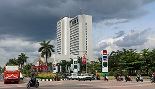
Surakarta, known colloquially as Solo, is a major city in Central Java, Indonesia. The 46.72 km2 (18.04 sq mi) city adjoins Karanganyar Regency and Boyolali Regency to the north, Karanganyar Regency and Sukoharjo Regency to the east and west, and Sukoharjo Regency to the south. On the eastern side of Solo lies Solo River. Its metropolitan area, consisting of Surakarta City and the surrounding six regencies, was home to 6,837,753 inhabitants according to the official estimates for mid 2023, 526,870 of whom reside in the city proper.

Bojonegoro Regency is a regency in East Java Province of Indonesia, about 110 km west of Surabaya and 73 km northeast of Ngawi. It covers a land area of 2,307.06 km2 and is located in the inland part of the northern Java plain, mainly on the south bank of the Solo River, the longest river in Java. It had a population of 1,209,973 at the 2010 Census and 1,301,635 at the 2020 Census; the official estimate as at mid-2023 was 1,363,058. The administrative centre of the regency is the town of Bojonegoro.

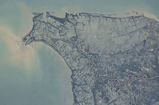
The Ciliwung is a 119 km long river in the northwestern region of Java where it flows through two provinces, West Java and the special region of Jakarta. The natural estuary of the Ciliwung, known as the Kali Besar, was an important strategic point for trade in the precolonial and colonial periods and was instrumental in the founding of the port city of Jakarta, but has been lost from a reorganization of the watercourse of the rivers around the area into canals.

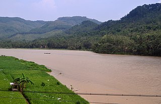
The Solo River is the longest river in the Indonesian island of Java. It is approximately 600 km (370 mi) in length.
Pacitan Regency is a regency located in the southwestern corner of East Java Province, with Central Java Province on its western border. Located between 7.55° - 8.17°S and 110.55° - 111.25°E. The borders of Pacitan Regency are with Wonogiri Regency in the west and north, Ponorogo Regency and Trenggalek Regency in the east, and the Indian Ocean in the south. It covers an area of 1,389.87 km2 and had a population of 540,881 at the 2010 census and 586,110 at the 2020 census; the official estimate as at mid 2023 was 597,390. The capital of Pacitan Regency is the town of Pacitan. The majority of citizens in Pacitan speak Javanese as their first language, while speaking Indonesian as a second language.
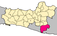
Wonogiri Regency is a regency in the southeastern part of Central Java province in Indonesia. It covers an area of 1,904.32 km2, and its population was 928,904 at the 2010 Census and 1,043,177 at the 2020 Census; the official estimate as at mid 2023 was 1,051,085. The capital and largest town is Wonogiri, around 33 km southeast of the large Central Java metropolis of Surakarta.

Sumedang Regency is a landlocked regency (kabupaten) of the West Java Province of Indonesia. The regency covers an area of 1,558.72 km2 and had a population of 1,093,602 at the 2010 Census and 1,152,507 at the 2020 Census; the official estimate as of mid-2023 was 1,178,235 - comprising 593,815 males and 584,420 females. Its administrative centre is in the district of North Sumedang.

Gunungkidul is a regency area located in the Special Province of the Daerah Istimewa Yogyakarta, Indonesia. The administrative centre is the town of Wonosari. The name "Gunungkidul" comes from the Javanese language mountains in the south of Java Land, whose area is located in the Thousand Mountains range of the province.
Sukoharjo Regency is a regency in the Central Java province in Indonesia. It covers an area of 493.23 km2 and had a population of 824,238 at the 2010 Census and 907,587 at the 2020 Census; the official estimate as of mid-2023 was 932,680. Its administrative centre is in the town of Sukoharjo, about 10 km south of Surakarta. This regency is bordered by the city of Surakarta in the north, Karanganyar Regency in the east, Wonogiri Regency and Yogyakarta in the south as well as Klaten Regency in the west. The regency is part of the metropolitan zone of Surakarta, which is known as Subosukawonosraten.
The Citarum River is the longest and largest river in West Java, Indonesia. It is the third longest river in Java, after Bengawan Solo and Brantas. It plays an important role in the life of the people of West Java. It has been noted for being considered one of the most polluted rivers in the world.
The Serayu River is a river in Central Java, Indonesia, about 300 km southeast of the capital Jakarta.
The Cirata Dam is an embankment dam on the Citarum River in West Java, Indonesia. It is located 100 km (62 mi) southeast of Jakarta. It was constructed between 1984 and 1988 for the primary purpose of hydroelectric & photovoltaic power generation. Other purposes include flood control, aquaculture, water supply and irrigation. The 125 m (410 ft) tall concrete-face rock-fill dam is situated just before a sharp bend in the river and withholds a reservoir with a gross storage capacity of 2,165,000,000 m3 (1,755,194 acre⋅ft). The reservoir has a surface area of 62 km2 (24 sq mi) which caused the relocation of 6,335 families. The construction of the dam resulted in involuntary resettlement of 56,000 people.

The Saguling Dam is an embankment dam on the headwater of Citarum River in West Java, Indonesia. It is located 26 km (16 mi) west of Bandung. Construction began in 1983. The reservoir had filled by 1985 and the first generator was operational in 1986. The primary purpose of the dam is hydroelectric power generation but it also provides for water supply and aquaculture. The 99 m (325 ft) tall dam is rock-fill embankment-type with watertight core that withholds a reservoir with a capacity of 2,750,000,000 m3 (2,229,461 acre⋅ft). Its power station has 4 x 175 MW Francis turbine generators with an installed capacity of 700 MW. Including land acquisition, the cost of the dam with power plant was about $US 663 million. The installed capacity of the power plant might be expanded to 1,400 MW in the future. The construction of the dam resulted in displacement of nearly 60,000 people.

The Jatigede Dam is an embankment dam on the Cimanuk River in Sumedang Regency, West Java, Indonesia. It is located 19 km (12 mi) east of the town of Sumedang. Construction on the dam began in 2008 and it was completed in 2015. The power station is expected to be commissioned in 2019. The primary purpose of the dam is irrigation but it will also provide for flood control, water supply and hydroelectric power generation. Water in the reservoir will be used to help irrigate 90,000 ha of farmland and the power station is expected to have a 110 MW capacity. The project has become controversial, primarily due to the relocation of people in the future reservoir zone.
Sempor Dam is an embankment dam on the Sempor River in District Gombong, Kebumen, Central Java Province, Republic of Indonesia. In addition to being a tourist attraction Sempor Dam is a source of irrigation water for farmers. It helps irrigate thousands of paddy fields in the delta. It also provides for flood control and has a 1 MW hydroelectric power station at its base. Construction on the dam started in 1967 but in the same year water from flash floods over-topped it, causing the dam to fail on 29 November 1967. The wave of water killed 160 people in three towns, including Magelang. and delivered widespread damage to the area. Construction later restarted on the dam and it was completed in 1978. Its power station was later commissioned in 1980.

The Bili-Bili Dam is a dam located in Gowa Regency, South Sulawesi, Indonesia, on the Jeneberang River, about 30 km from the city of Makassar. It provides flood control, irrigation, and hydroelectric power generation. The dam was constructed between 1991 and 1998.
The Madiun River is a river in East Java, Indonesia, about 500 km to the east of the capital Jakarta. It is the largest tributary of the Solo River. Its name indicates that it passes through the major city of Madiun, East Java, Indonesia. This river starts as several smaller tributaries converging near the city of Ponorogo, in particular the Kali Slahung, Kali Keyang, and Kali Sungkur. It eventually converges with the Solo River near the city of Ngawi.
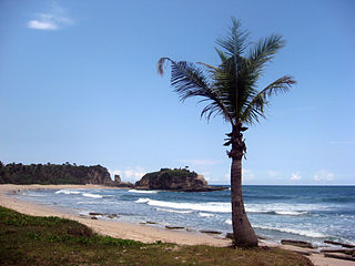
Ci Tanduy is a river in the island of Java, Indonesia, about 270 km to the southeast of the capital Jakarta. It flows from West Java to Central Java province, exiting through the Bay of Citanduy to the Indian Ocean, forming a delta called "Muara Citanduy."
Kedung Ombo Reservoir is one of the major reservoirs in Indonesia. It is located on the border of three regencies in Central Java Province, namely Grobogan Regency, Sragen Regency, and Boyolali Regency, in District Geyer, Grobogan District. The main dam of Kedung Ombo Reservoir is located on the border of Rambat Village and Juworo Village, Geyer Sub-District, Grobogan District. This reservoir uses Serang River as its main source of water, along with the Uter/Sungai Kombo/Banjaran River. Other water sources are supplied from several large and small rivers that supply water to Kedung Ombo Reservoir, including the Braholo River, Central River, Nglanji River, Tapen River and Sambas River.

