Kedung Ombo Dam

Last updated
Kedung Ombo Dam
Indonesia relief location map.jpg
Red pog.svg
Location of Kedung Ombo Dam in Indonesia
Country Indonesia
Location Central Java, Indonesia
Coordinates Coordinates: 7°15′13″S110°50′07″E / 7.253549°S 110.835339°E / -7.253549; 110.835339
StatusOperational
Construction began1985
Opening date1991
Dam and spillways
Type of dam Embankment, rock-fill with watertight core
Impounds Serang River
Height96 m (315 ft)
Length1,600 m (5,249 ft)
Reservoir
Total capacity6,880,000,000 m3 (5,577,707 acre⋅ft) [1]
Power Station
Operator(s)PT Indonesia Power
Commission date1991
Installed capacity 22.5 MW

Kedung Ombo Reservoir is one of the major reservoirs in Indonesia. It is located on the border of three regencies in Central Java Province, namely Grobogan Regency, Sragen Regency, and Boyolali Regency, in District Geyer, Grobogan District. The main dam of Kedung Ombo Reservoir is located on the border of Rambat Village and Juworo Village, Geyer Sub-District, Grobogan District. This reservoir uses Serang River as its main source of water, along with the Uter/Sungai Kombo/Banjaran River. Other water sources are supplied from several large and small rivers that supply water to Kedung Ombo Reservoir, including the Braholo River, Central River, Nglanji River, Tapen River and Sambas River. [2]

Contents

Development

In 1985, the government planned to build a new reservoir in Central Java for a 22.5 Megawatt (MW) power plant and to provide water for the surrounding 70 Hectare rice fields. The construction of Kedungombo Reservoir was funded by USD 156 million from the World Bank, USD 25.2 million from the Japan Export-Import Bank, and the State Revenue and Expenditure Budget (APBN), starting from 1985 until 1989.

The project met with substantial resistance from local residents who faced displacement, many of whom rejected the compensation offered as inadequate [3] and claimed that the land where the government allowed them to resettle was unfit for cultivation, had no drinking water, and was virtually inaccessible by road. [4] Over 1,500 families remained in their villages, even as the reservoir began to flood their homes. [5]

Student groups such as the Kedung Ombo Construction Victims Solidarity Group helped draw media attention, both nationally and worldwide, to villagers' complaints and build public support for their demands. [6] Non-governmental organizations such as the International NGO Forum on Indonesian Development (founded in 1985 under the name the Inter-NGO Conference o­n IGGI Matters, or INGI), [7] brought these complaints before the World Bank, obtaining an aide-mémoire that put pressure on the government to address these complaints. [8]

The government, hard-pressed by the deadlines for construction of the dam imposed as a condition of the grant from the Japan Export-Import Bank, continued to pressure residents to accept the compensation offered and leave the area, while curtailing the activities of NGOs, support groups, and the media. [9] At the same time, in an attempt to lessen villagers' protests without addressing their complaints, the authorities allowed residents to continue farming greenbelt areas and tidal lands around the reservoir. [10]

The villagers nonetheless continued to resist, bringing a lawsuit to obtain better terms. The suit made its way to the Indonesian Supreme Court, which in 1993 awarded 9 billion rupiah (USD $3.9 million) to thirty-four households for the damage done to their land, buildings, and crops and the loss of their homes. [11] That victory proved to be short-lived: after the government protested, the Court reversed itself in 1994 and revoked its own decision. [12]

The reservoir began to be irrigated on January 14, 1989. Cangkupan puddle reservoir reaches 6,576 hectares (Waters 2,830 hectares and land area 3.746 hectares) by drowning 37 villages, seven districts in three districts, namely Sragen, Boyolali, and Grobogan. A total of 5,268 families at that time lost their land due to the construction of this dam; some moved onto rafts or into trees, others were stranded on newly formed islands, and others shifted as much of their houses and belongings as they could rescue onto higher ground, only to be flooded out again as the reservoir rose further. [13] The reservoir was finally inaugurated by President Soeharto on May 18, 1991.

Uses

See also

Related Research Articles

<span class="mw-page-title-main">Central Java</span> Province of Indonesia

Central Java is a province of Indonesia, located in the middle of the island of Java. Its administrative capital is Semarang. It is bordered by West Java in the west, the Indian Ocean and the Special Region of Yogyakarta in the south, East Java in the east, and the Java Sea in the north. It has a total area of 32,800.69 km2, with a population of 36,516,035 at the 2020 Census making it the third-most populous province in both Java and Indonesia after West Java and East Java. The official estimate as at mid 2021 was 36,742,501. The province also includes the island of Nusakambangan in the south, and the Karimun Jawa Islands in the Java Sea.

<span class="mw-page-title-main">Sardar Sarovar Dam</span> Dam in Gujarat, India

The Sardar Sarovar Dam is a concrete gravity dam built on the Narmada River in Navagam near the town of Kevadiya, Narmada District, in the state of Gujarat, India. The dam was constructed to provide water and electricity to four Indian states: Gujarat, Madhya Pradesh, Maharashtra, and Rajasthan.

<span class="mw-page-title-main">Subarnarekha River</span> River in northeastern India

The Subarnarekha River flows through the Indian states of Jharkhand, West Bengal and Odisha.

<span class="mw-page-title-main">Boyolali Regency</span> Regency in Indonesia

Boyolali is a regency in the eastern part of Central Java province in Indonesia. It covers an area of 1,015.10 km2, and had a population of 930,531 at the 2010 census and 1,062,713 at the 2020 census.

Tawa Reservoir is a reservoir on the Tawa River in central India. It is located in Itarsi of Narmadapuram District of Madhya Pradesh state, above Betul district. The reservoir was formed by the construction of the Tawa Dam, which began in 1958 and was completed in 1978. The dam provides for irrigation to several thousand hectares of farming land in Narmadapuram and Harda districts. It is also a big tourist attraction during the monsoon months. A cruise boat service has been started by the tourism department for visitors to the dam and reservoir.

<span class="mw-page-title-main">Damodar Valley Corporation</span> Multipurpose river valley project in India

Damodar Valley Corporation (DVC) is a government-owned power generator which operates in the Damodar River area of West Bengal and Jharkhand states of India. The statutory corporation operates both thermal power stations and hydel power stations under the ownership of Ministry of Power, Government of India. DVC is headquartered in the Kolkata city of West Bengal, India.

Grobogan Regency is a regency located in northeastern part of the Central Java province in Indonesia.

<span class="mw-page-title-main">Karanganyar Regency</span> Regency in Indonesia

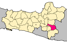
Karanganyar Regency is a regency in the Indonesian province of Central Java. It covers an area of 773.79 km2 and had a population of 813,196 at the 2010 Census and 931,963 at the 2020 Census. Its capital is the town of Karanganyar.

<span class="mw-page-title-main">Manyuchi Dam</span> Body of water

Manyuchi Dam forms a reservoir on the Mwenezi River in southern Zimbabwe. It is located in the Mwenezi District. The building of the dam was financed by the Mwenezi Development Corporation. The dam was built to irrigate oil palm estates.

Rengali dam is a dam located in Odisha, India. It is constructed across the Brahmani River in Rengali village, located 70 km from Angul in Angul district.

<span class="mw-page-title-main">Bakolori Dam</span> Dam in Nigeria

The Bakolori Dam is in Sokoto State in northwest Nigeria. It was completed in 1978 and its reservoir filled by 1981. It is a major reservoir on the Sokoto River, a tributary of the Rima River, which in turn feeds the Niger River. Water from the dam supplies the Bakolori Irrigation Project.

<span class="mw-page-title-main">Jatigede Dam</span> Dam in Sumedang, West Java

The Jatigede Dam is an embankment dam on the Cimanuk River in Sumedang Regency, West Java, Indonesia. It is located 19 km (12 mi) east of the town of Sumedang. Construction on the dam began in 2008 and it was completed in 2015. The power station is expected to be commissioned in 2019. The primary purpose of the dam is irrigation but it will also provide for flood control, water supply and hydroelectric power generation. Water in the reservoir will be used to help irrigate 90,000 ha of farmland and the power station is expected to have a 110 MW capacity. The project has become controversial, primarily due to the relocation of people in the future reservoir zone.

<span class="mw-page-title-main">Kanjirapuzha Dam</span> Dam in Kerala, India

The Kanjirapuzha Dam, a masonry earth dam built for providing irrigation to a Cultural Command Area (CCA) of 9,713 hectares, is located in the Palakkad district in the Indian state of Kerala. The reservoir, which has three islands within it, also has an established commercial fisheries development programme operated by the Fisheries Department.

Ci Tanduy is a river in the island of Java, Indonesia, about 270 km to the southeast of the capital Jakarta. It flows from West Java to Central Java province, exiting through the Bay of Citanduy to the Indian Ocean, forming a delta called "Muara Citanduy."

<span class="mw-page-title-main">Gajah Mungkur Dam</span> Dam in Central Java, Indonesia

Gajah Mungkur Reservoir (Dam) is a water reservoir located at Pokohkidul in the Wonogiri Regency, Central Java, of Indonesia. It was constructed by redirecting the Bengawan Solo River, the longest in the Java Islands, which originates from The Gajah Mungkur Mountain. The maximum inundation area of Gajah Mungkur Reservoir is 8,800 hectares and covers the seven subdistricts of Wonogiri, Ngadirojo, Nguntoronadi, Baturetno, Giriwoyo, Eromoko, and Wuryantoro.

<span class="mw-page-title-main">Kedungbanteng, Tegal</span> District in Central Java, Indonesia

Kedungbanteng is a district located in the eastern part of Tegal Regency, Central Java, Indonesia. The Kedungbanteng district is 8 km drive from the center of regency, namely Slawi Town through southern of Pangkah district. The central government is located in the village of Kedungbanteng.

Mochamad Hasbi was an Indonesian army officer and politician who served as the Regent of Boyolali from 1984 until 1994 and the deputy speaker of the Central Java Regional People's Representative Council from 1999 until 2007.

References

  1. "Kapasitas Saluran Air Menurun, Waduk Kedung Ombo Direhabilitasi". Kompas. Retrieved 5 October 2017.
  2. "RI prepares for worst as El Niño causes prolonged dry season". The Jakarta Post. Retrieved 5 October 2017.
  3. Hanif, Muhammad Ismail; Sastrodinomo, Kasijanto (2021). "The Resistance Towards the Kedung Ombo Dam Construction of 1985-1991". Advances in Economics, Business and Management Research. 168: 44. Retrieved July 14, 2022.
  4. McCully, Patrick (1994). "Update on the deadly Kedung Ombo resettlement Fiasco". Bulletin of Concerned Asian Scholars. 26 (4): 85. doi: 10.1080/14672715.1994.10416178 .
  5. Fiasco p. 84.
  6. Resistance p. 47.
  7. "International NGO Forum on Indonesian Development (INFID)".
  8. Resistance p. 48.
  9. Fiasco p. 85.
  10. Rajagukguk, Erman (1994). "Law, Land, and the Natural Environment in the Kedungombo Greenbelt Area at the Central Javanese Village of Giliredjo". Law & Society Review. 28 (3): 623–629. doi:10.2307/3054081. JSTOR   3054081 . Retrieved July 14, 2022.
  11. Fiasco p. 84.
  12. Fiasco pp. 84-85.
  13. Fiasco p.84.