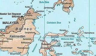
Sulawesi, also known as Celebes, is an island in Indonesia. One of the four Greater Sunda Islands, and the world's 11th-largest island, it is situated east of Borneo, west of the Maluku Islands, and south of Mindanao and the Sulu Archipelago. Within Indonesia, only Sumatra, Borneo, and Papua are larger in territory, and only Java and Sumatra have larger populations.

Buginese or Bugis is a language spoken by about 4 million people mainly in the southern part of Sulawesi, Indonesia.

The Celebes Sea or Sulawesi Sea of the western Pacific Ocean is bordered on the north by the Sulu Archipelago and Sulu Sea and Mindanao Island of the Philippines, on the east by the Sangihe Islands chain, on the south by Sulawesi's Minahasa Peninsula, and on the west by northern Kalimantan in Indonesia. It extends 420 miles (675 km) north-south by 520 mi (840 km) east-west and has a total surface area of 110,000 square miles (280,000 km2), to a maximum depth of 20,300 feet (6,200 m). South of the Cape Mangkalihat, the sea opens southwest through the Makassar Strait into the Java Sea.

Makassar Strait is a strait between the islands of Borneo and Sulawesi in Indonesia. To the north it joins the Celebes Sea, while to the south it meets the Java Sea. To the northeast, it forms the Sangkulirang Bay south of the Mangkalihat Peninsula. The strait is an important regional shipping route in Southeast Asia.

The Banda Sea is one of four seas that surround the Maluku Islands of Indonesia, connected to the Pacific Ocean, but surrounded by hundreds of islands, including Timor, as well as the Halmahera and Ceram Seas. It is about 1000 km (600 mi) east to west, and about 500 km (300 mi) north to south.

James Ross Island is a large island off the southeast side and near the northeastern extremity of the Antarctic Peninsula, from which it is separated by Prince Gustav Channel. Rising to 1,630 metres (5,350 ft), it is irregularly shaped and extends 64 km in a north–south direction. It was charted in October 1903 by the Swedish Antarctic Expedition under Otto Nordenskiöld, who named it for Sir James Clark Ross, the leader of a British expedition to this area in 1842 that discovered and roughly charted a number of points along the eastern side of the island. The style, "James" Ross Island is used to avoid confusion with the more widely known Ross Island in McMurdo Sound.

The Hoover Wilderness is a wilderness area in the Inyo and Humboldt-Toiyabe National Forests. It lies to the east of the crest of the central Sierra Nevada in California, to the north and east of Yosemite National Park - a long strip stretching nearly to Sonora Pass on the north and Tioga Pass on the south.

Donggala Regency is a regency in the Central Sulawesi Province of Indonesia. It lies between 0° 30" north and 2°20" south latitude, and between 119° 45°" and 121° 45" east longitude, and covers a land area of 5,275.69 km2. It had a population of 277,236 at the 2010 Census and 300,436 at the 2020 Census; the official estimate as at mid 2022 was 305,890. The administrative capital of Donggala Regency is the town of Banawa, located a 30-minute drive (34 km) northwest from the city of Palu, the capital of the province.

The Flores Sea covers 240,000 square kilometres (93,000 sq mi) of water in Indonesia. The sea is bounded on the north by the island of Celebes and on the south by Sunda Islands of Flores and Sumbawa.

The Molucca Sea is located in the western Pacific Ocean, around the vicinity of Indonesia, specifically bordered by the Indonesian Islands of Celebes (Sulawesi) to the west, Halmahera to the east, and the Sula Islands to the south. The Molucca Sea has a total surface area of 77,000 square miles. The Molucca Sea is rich in coral and has many diving sites due to the deepness of its waters. The deepness of the water explains the reasoning behind dividing the sea into three zones, which functions to transport water from the Pacific Ocean to the shallower seas surrounding it. The deepest hollow in the Molucca Sea is the 15,780-foot (4,810-meter) Batjan basin. This region is known for its periodic experiences of earthquakes, which stems from the sea itself being a micro plate, in which the Molucca Sea is being subducted in two opposite directions: one in the direction of the Eurasian Plate to the west and the other in the direction of the Philippine Sea Plate to the east.

Parepare is a city (kota) in South Sulawesi, Indonesia, located on the southwest coast of Sulawesi, about 155 km (96 mi) north of the provincial capital of Makassar. A port town, it is one of the major population centers of the Bugis people. The city had a population of 129,542 people at the 2010 Census and 151,454 at the 2020 Census; its official estimate as at mid 2022 was 154,854.
Serra Negra is a small mountain range on the border of Brazilian states Sergipe and Bahia. Its highest elevation is 742 m. The nearest town is Pedro Alexandre.

Lake Tempe is a lake in South Sulawesi, Indonesia. It is located at 4°6′20″S119°56′49″E. The town of Sengkang is situated to the east of the lake.

The Kingdom of Luwu was a polity located in northern part of South Sulawesi. province of Indonesia, on Sulawesi island. It is considered one of the earliest known Bugis kingdom in Sulawesi, founded between 10th and 14th century. However, recent archaeological research has challenged the idea.

Micereces de Tera is a municipality located in the province of Zamora, Castile and León, Spain. According to the 2004 census (INE), the municipality has a population of 595 inhabitants.

Daule, is a canton located in the Guayas province in Ecuador. Created in 1820, it is one of the most important parts of Guayas thanks to its rice production and other products such as corn and eggs.

Nova Serrana is a municipality in the state of Minas Gerais in the Southeast region of Brazil.

Sidenreng Rappang Regency is a landlocked regency of South Sulawesi Province in Indonesia. It has an area of 1,883.25 kilometres (1,170.20 mi) and had a population of 271,911 at the 2010 Census and 319,990 at the 2020 Census; the official estimate as at mid 2022 was 327,416. Its capital is at the town of Pangkajene Sidenreng. The original inhabitants of this area are Bugis.
Rappang is a small town in the Panca Rijang District, Sidenreng Rappang Regency in South Sulawesi, Indonesia. The village is located 32.7 kilometres (20.3 mi) north east of Pare-Pare.


