North Kazakhstan Region

Last updated
North Kazakhstan Region
Солтүстік Қазақстан облысы (Kazakh)
Imantau osen'.jpg
Kazakhstan Petropavlovsk Podgora Petropavlovskiy sobor 2.jpg
Ideal'no krugloe ozero Logovoe SKO.jpg
From the top, Lake Imantau, Saints Peter & Paul Orthodox Cathedral in Petropavlovsk, Lake Arykbalyk
Bandera de la Region del norte de Kazajstan.svg
North Kazakhstan province seal.svg
North Kazakhstan in Kazakhstan.svg
Map of Kazakhstan, location of North Kazakhstan Region highlighted
Coordinates: 54°53′N69°10′E / 54.883°N 69.167°E / 54.883; 69.167
Country Flag of Kazakhstan.svg Kazakhstan
Date of formationJuly 29 1936
Capital Petropavl
Government
   Akim Gauez Nurmukhambetov [1]
Area
[2]
  Total
97,993 km2 (37,835 sq mi)
Population
 (2025-01-01) [3]
  Total
522,171
  Density5.3287/km2 (13.801/sq mi)
GDP (Nominal, 2024)
[4]
  Total KZT 2,654 billion
(US$ 5.573 billion) · 18th
  Per capitaKZT 5,044,000
(US$ 10,592)
Time zone UTC+5
  Summer (DST) UTC+5 (not observed)
Postal codes
150000
Area codes +7 (715)
ISO 3166 code KZ-SEV
Vehicle registration 15, T
Districts 13
Cities 5
Villages 208
HDI (2023)0.850 [5]
very high · 3rd
Website www.sko.kz

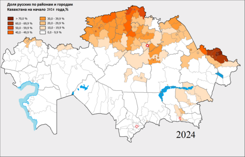
North Kazakhstan Region [a] is a region of Kazakhstan with a population of 522,171. Its capital is Petropavl, with a population of 221,907 people. It is the only region of Kazakhstan in which ethnic Kazakhs don't make up a majority.

Contents

History

North Kazakhstan region in 1987 SKO-1987.png
North Kazakhstan region in 1987

During the 19th century, the territory of the region was home to several Middle Zhuz tribes, including Argyns, Kerei, and Kypshak. During the late 19th and early 20th centuries, the region underwent significant resettlement as a result of the opening of the Siberian railway and the Stolypin agrarian reform. As a result, Ukrainians became the majority population in the northern regions of Kazakhstan and the area was referred to as the "Grey Wedge." [6]

In the early 20th century, the North Kazakhstan region was the center of the Akmola province of the Kirghiz Autonomous Soviet Socialist Republic (ASSR). The West Siberian uprising, a large anti-Bolshevik armed uprising, was suppressed by the Reds during this time. The North Kazakhstan region was officially formed from the northern regions of the Karaganda region and the Karkaralinsky district in 1936.

In 1939, the city of Stepnyak and 11 southern districts were ceded to the newly formed Akmola region. In 1966, the North Kazakhstan region was awarded the Order of Lenin. The administrative-territorial reform of 1997 resulted in the inclusion of several districts of the abolished Kokchetav region into the North Kazakhstan region, which had a large proportion of the Kazakh population. The region's structure included modern districts such as Akkayynsky, Esilsky, Zhambylsky, Bulaevsky, and Timiryazevsky, among others, in which the Russian population was predominantly still living.

Geography

The region borders Russia (Omsk Oblast, Kurgan Oblast and Tyumen Oblast) to the north, and also borders three other Kazakhstan regions: Akmola Region to the south, Pavlodar Region to the east and Kostanay Region to the west. The area of the region is 98,040 km2 (37,850 sq mi), making it the fourth smallest of all the regions of Kazakhstan. The Kokshetau Hills stretch along the southern part, limited to the north by the West Siberian Plain. The Ishim (Esil) River, a tributary of the Irtysh River, flows from Karagandy Region to Russia through North Kazakhstan Region. The Sileti river also flows through the region. [7] [8]

Demographics

The share Russians by districts and cities of regional and republican subordination Kazakhstan in 2024 Russians in Kazakhstan Rus.png
The share Russians by districts and cities of regional and republican subordination Kazakhstan in 2024
YearPopulation [9] [10] [11] [12]
1979884,345
1989912,065
1999725,980
2003682,148
2004674,497
2005665,936
2006663,126
2007660,950
2008653,921
2009597,530
2010592,746
2011589,308
2012583,598
2013579,636
2014575,766
2015571,759
2017558,700
2021543,679
2025522,171

Ethnic groups

Ethnic group2021 census [13] 2025 estimate [14]
Population%Population%
Russians 240,56744.48231,80444.39
Kazakhs 203,17637.57197,13137.75
Ukrainians 29,9505.5428,0355.37
Germans 22,2074.1121,5814.13
Tatars 12,0992.2411,5202.21
Poles 11,3182.0910,5862.03
Belarusians 6,8051.266,4511.24
Azeris 1,7210.321,8640.36
Other ethnicity or not stated13,0332.4113,1992.53
Total540,786100%522,171100%

Religion

Religion2021 [13]
Population%
Christianity 298,28855.16
Islam 209,39738.72
No Religion 10,0351.86
Buddhism 1880.03
Judaism 1230.02
Other Religion8320.15
Not Stated21,9234.05
Total540,786100%

Administrative divisions

The region is administratively divided into thirteen districts and the city of Petropavl. [15]

  1. Akkayin District, with the administrative center in the selo of Smirnovo;
  2. Akzhar District, the selo of Talshik;
  3. Aiyrtau District, the selo of Saumalkol;
  4. Esil District, the selo of Yavlenka;
  5. Gabit Musirepov District, the selo of Novoishim;
  6. Kyzylzhar District, the selo of Beskol;
  7. Magzhan Zhumabayev District, the town of Bulayevo;
  8. Mamlyut District, the town of Mamlyut;
  9. Shal akyn District, the town of Sergeyev;
  10. Taiynsha District, the town of Taiynsha;
  11. Timiryazev District, the selo of Timiryazevo;
  12. Ualikhanov District, the selo of Kishkenekol;
  13. Zhambyl District, the selo of Presnovka.

The following five localities in North Kazakhstan Region have town status: [15] Petropavl, Bulayevo, Mamlyut, Sergeyev, and Taiynsha.

Sport

The regional bandy team took part in the national championship in 2016.

Notes

  1. Kazakh: Солтүстік Қазақстан облысы, romanized: Soltüstık Qazaqstan oblysy

References

  1. "Gauez Nurmukhambetov appointed Governor of North Kazakhstan region". inform.kz. 2023-09-23.
  2. Official site - General Information
  3. Agency of statistics of the Republic of Kazakhstan: Численность населения Республики Казахстан по областям с начала 2013 года до 1 февраля 2013 года (russisch; Excel-Datei; 55 kB).
  4. DOSM. "Gross domestic product by region for January-December 2024 (GRP)". stat.gov.kz.
  5. "Sub-national HDI – Area Database – Global Data Lab". hdi.globaldatalab.org.
  6. "Украинцы в Казахстане: из истории переселений · Публикации · Портал "История Казахстана"". National digital history of Kazakhstan. 2 February 2015. Archived from the original on 2017-02-11. Retrieved 2023-02-09.
  7. Google Earth
  8. "N-42 Chart (in Russian)" . Retrieved 19 October 2022.
  9. "Kazakhstan: Regions, Major Cities & Settlements - Population Statistics, Maps, Charts, Weather and Web Information". www.citypopulation.de. Retrieved 2022-03-12.
  10. "Pourquoi le Nord du Kazakhstan se vide de ses habitants". Novastan français. 2018-08-09. Retrieved 2018-08-13.
  11. "Division of Kazakhstan". pop-stat.mashke.org. Retrieved 2016-03-29.
  12. Численность населения на начало года, регионы Республики Казахстан, 2003-2015
  13. 1 2 "2021 жылғы Қазақстан Республикасы халқының ұлттық санағының қорытындылары" [Results of the 2021 national census of the Republic of Kazakhstan]. Archived from the original on 2022-09-02. Retrieved 2023-03-07.
  14. "Population of the Republic of Kazakhstan by individual ethnic groups and age groups (at the beginning of 2025)". stat.gov.kz. Retrieved 2025-04-19.
  15. 1 2 Акиматы районов, г. Петропавловска (in Russian). Официальный интернет-ресурс Северо-Казахстанской области. Archived from the original on 8 August 2013. Retrieved 13 June 2012.