
The Turgay is a river in Kazakhstan. It has a length of 825 km (513 mi) and a drainage basin of 157,000 km2 (61,000 sq mi).

Dipor Bil, also spelt Deepor Beel , is located to the south-west of Guwahati city, in Kamrup Metropolitan district of Assam, India. It is a permanent freshwater lake, in a former channel of the Brahmaputra River, to the south of the main river. It is also called a wetland under the Ramsar Convention which has listed the lake in November 2002, as a Ramsar Site for undertaking conservation measures on the basis of its biological and environmental importance.

The wildlife of Libya is spread over the Mediterranean coastline and encompasses large areas of the Saharan desert. The protection of wildlife is provided through appropriate legislation in seven national parks, five reserves, 24 protected areas, two wetlands under Ramsar Convention, and also in other areas. Apart from these, there are also five UNESCO World Heritage Sites related to culture. The most important national parks are the El-Kouf National Park and Karabolli National Park. The well known nature reserves are the Benghazi Reserve and the Zellaf Reserve. The wildlife species recorded in the country are 87 mammals and 338 species of birds.
The Irgiz is a river in Aktobe and Kostanay regions of Kazakhstan, a right tributary of the Turgay. It is 593 kilometres (368 mi) long, and has a drainage basin of 31,600 square kilometres (12,200 sq mi). It was the site of the Battle of the Irghiz River in the early 13th century.

The Kanwar Taal or Kabar Taal Lake or Kabartal Wetland located in Begusarai district of Bihar, India, is Asia's largest freshwater oxbow lake. It is approximately six times the size of the Bharatpur Sanctuary. In November 2020, the Ministry of Environment, Forest and Climate Change (MoEFCC) declared it the first Ramsar site in Bihar. There are a total of 75 Ramsar Sites in India till 2022.

The Coongie Lakes is a freshwater wetland system located in the Far North region of South Australia. The 21,790-square-kilometre (8,410 sq mi) lakes system is located approximately 1,046 kilometres north of the Adelaide city centre. The wetlands includes lakes, channels, billabongs, shallow floodplains, deltas, and interdune swamps. It lies on the floodplain of Cooper Creek, an ephemeral river flowing through a desert landscape in the Lake Eyre Basin which rarely, after occasional large floods, empties into Lake Eyre. The wetland system has been recognised both as being of international importance by designation under the Ramsar Convention with a listing on 15 June 1987 and being nationally important within Australia with a listing in A Directory of Important Wetlands in Australia (DIWA). Its extent includes the regional town of Innamincka, the Malkumba-Coongie Lakes National Park, the Innamincka Regional Reserve, the Strzelecki Regional Reserve and the Coongie Lakes Important Bird Area.
The Paroo Floodplain and Currawinya Important Bird Area is a 7,874 km2 (3,040 sq mi) site comprising the floodplain and the associated wetlands of the Paroo River in north-western New South Wales and south-western Queensland, Australia. It includes extensive areas of the Paroo-Darling and Currawinya National Parks, both of which are listed under the Ramsar Convention as wetland sites of international importance, as well as of the Nocoleche Nature Reserve.
Naurzum State Nature Reserve is a nature reserve in Kostanay Region, Kazakhstan. It is part of the UNESCO heritage site Saryarka — Steppe and Lakes of Northern Kazakhstan. It protects about 3,081 square kilometres (1,190 sq mi) of steppes, semi desert and forests. The administrative office of the protected area is located in Karamendy village.

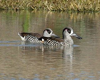
Korgalzhyn State Nature Reserve is a protected area in Aqmola and Karaganda regions of Kazakhstan, located west of the city of Astana. It is part of the UNESCO heritage site Saryarka — Steppe and Lakes of Northern Kazakhstan, Ramsar site and biosphere reserve.

The wildlife of Ukraine consists of its diverse fauna, flora and funga. The reported fauna consists of 45,000 species when including the areas of the Black Sea and the Sea of Azov. Ukraine's protected environments consist of 33 Ramsar sites covering an area of 7,446.51 square kilometres (2,875.11 sq mi). Biosphere nature reserves and three national parks are all part of the GEF projects portfolio of conservation of biodiversity in the Danube Delta. Their vegetation pattern is mixed forest area, forest-steppe area, steppe area, Ukrainian Carpathian Mountains and Crimean Mountains. Some of the protected areas that were reserves or parks are subsumed under the biosphere reserves.
Chowilla Regional Reserve is protected area in the Australian state of South Australia located in the gazetted locality of Chowilla about 250 kilometres (160 mi) north-east of the state capital of Adelaide.

The Alakol Biosphere Reserve is a UNESCO Biosphere Reserve located in Kazakhstan, within the desert zone of Eurasia in the central part of the Alakol inter-mountain depression. The 193,089 hectares (745.52 sq mi) reserve lies on the Central Asian–Indian bird migration route. The wetlands of the reserve are of global significance as a habitat and as a nesting site for water birds.

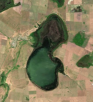
Shalkarteniz is an extensive salt flat and seasonal lake in the Yrgyz District, Aktobe Region, Kazakhstan.

The Turgay Depression, also known as Turgay Basin, Turgay Trough, and Turgay Hollow, is a structural basin in Kazakhstan.
Koybagar is a lake in the Kostanay Region, Kazakhstan.

Tyuntyugur is a lake in the Kostanay Region, Kazakhstan.

The Ulkayak is a river in Kazakhstan. It has a length of 349 kilometres (217 mi) and a catchment area of 13,300 square kilometres (5,100 sq mi).

Baitakkol, is a lake in Yrgyz District, Aktobe Region, Kazakhstan.

Urkash is a lake in Kamysty District, Kostanay Region, Kazakhstan.

