
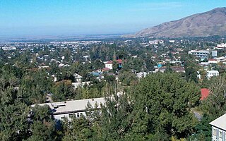
Almaty, formerly Alma-Ata, is the largest city in Kazakhstan, with a population of over two million. It was the capital of Kazakhstan from 1929 to 1936, while the country was an autonomous republic of the Soviet Union, then from 1936 to 1991, a union republic and finally from 1991, an independent state. In 1997, the government relocated the capital to Akmola.

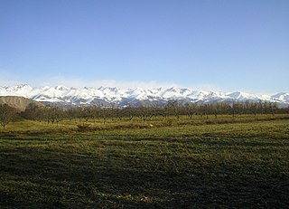
The Tian Shan, also known as the Tengri Tagh or Tengir-Too, meaning the "Mountains of God/Heaven", is a large system of mountain ranges in Central Asia. The highest peak is at the Jengish Chokusu at 7,439 metres (24,406 ft) high. Its lowest point is at the Turpan Depression, which is 154 m (505 ft) below sea level.

Lake Balkhash, also spelt Lake Balqash, is a lake in southeastern Kazakhstan, one of the largest lakes in Asia and the 15th largest in the world. It is located in the eastern part of Central Asia and sits in the Balkhash-Alakol Basin, an endorheic (closed) basin. The basin drains seven rivers, the primary of which is the Ili, bringing most of the riparian inflow; others, such as the Karatal, bring surface and subsurface flow. The Ili is fed by precipitation, largely vernal snowmelt, from the mountains of China's Xinjiang region.

The Dzungarian Alatau is a mountain range that lies on the boundary of the Dzungaria region of China and the Zhetysu region of Kazakhstan. It has a length of 450 km (280 mi) and a maximum elevation of 4,464 m (14,646 ft).

Ile Alatau, also spelt as Trans-Ili Alatau, is a part of the Northern Tian Shan mountain system in Kazakhstan and Kyrgyzstan. It is the northernmost mountain range of Tian Shan, stretching for about 350 km (220 mi) with a maximal elevation of 4,973 m (16,316 ft). The term "Alatau" refers to a kind of mountain. The range is bounded in the north by the Ili Depression of the Ili River, hence the name.
Talgar is a town in Almaty Region, southeastern Kazakhstan. It is the administrative center of Talgar District. The town is located between Almaty and Esik, 25 km from Almaty and several kilometres east of Birlik. Population: 45,529 ; 43,353.

Altyn-Emel National Park is a national park in Kazakhstan. It was created in 1996. The park covers about 4,600 km2 (1,800 sq mi) between the Ili River and the Ak-Tau mountain range, near Lake Kapchagai, and consists mostly of desert and rocky terrain.
Tekeli is a city in the Jetisu Region of Kazakhstan, located 310 km from Almaty city and 40 km from Taldykorgan city. At the beginning of 2019, the population of the city was 31,958.

The Issyk is a river in Kazakhstan that crosses the Issyk Lake and the town of Esik. It is a tributary of the river Ili.
The Kungey Alatau, also spelled Kungoy Ala-Too, and Kungey Alataw, is a mountain range, which forms the northern Tien Shan with Zailiyskiy Alatau. The word "Alatau" or "Ala-too" means "variegated mountains", a designation indicating a pronounced high-altitude zone of mountains, partly white due to snow, partly dark on snowless areas. The word "Kungey" or "Kyungei" means "the side facing to the South".

Ile-Alatau National Park is a national park in Kazakhstan. It was created in 1996 and covers about 200,000 ha. It is situated in the Trans-Ili Alatau mountains south of Almaty between Gorge Turgen in the east and Chemolgan River in the west. The national park borders Almaty Nature Reserve, which is located around Pik Talgar.

Big Almaty Lake is natural alpine reservoir. It is located in the Trans-Ili Alatau mountains, 15 km south from the center of Almaty in Kazakhstan. The lake is 2511 meters above sea level.

Zhongar-Alatau National Park, also Jungar Alatau, or Dzungurian Alatau, was created in 2010 to protect the unique ecology of the Dzungarian Alatau, an isolated, glaciated mountain range in Kazakhstan, on the southeastern border with China. One stated reason for creating the park is to protect forests of wild fruit trees, including apricots, barberry, cherries, and currants. Approximately 1% of the land area of the park is forested with Sievers Apple trees, which are the progenitors of all cultured apple varieties in the world. The park is 300 km long (west-to-east), and spreads across Aksu District, Sarkand District and Alakol District of Almaty Region, 300 km northeast of the regional city of Almaty.

The Chilik, Shilik, or Shelek is a major flowing river in the Almaty Region in the Republic of Kazakhstan, one of the largest left tributaries of the Ili, and the main waterway of southeastern Kazakhstan. The Bartogay reservoir has been created on the river, from where the Great Almaty canal begins.

Kairak Falls is a waterfall on the Kairak River in the Enbekshikazakh District in the south of Almaty Region of Kazakhstan on the right tributary of the Turgen River. The source of the river is located in the glaciers of the central part of the Zailiysky Alatau ridge, near the border of Enbekshikazakh and Talgar districts of Almaty region. It flows through the territory of the Ile-Alatau National Park, the prevailing direction of flow is north — northwest. Approximately about ten thousand years ago, the right tributary of the Turgen Bozgul river broke through a tunnel in the rocks, thereby forming the most powerful and unique waterfall in the T-ili Alatau. The Kairak waterfall is located on the northern slope of the Zailiysky Alatau mountain range in the OI-Karagay tract. The waterfall is located at an altitude of 2,130 m (6,990 ft) above sea level. The height of the water fall is about 55 m (180 ft), with thresholds 74 m (243 ft). The height exceeds the famous Niagara Falls in North America at 53 m (174 ft) The waterfall got its name not by chance. Kairak-translated from the Kazakh language-is a "sharpener", it literally cut its way into the gorge.
The Mynjylky Plateau is a plateau in an elevated plain in the Almaty Region of Kazakhstan.
Bayan-Zhurek is a mountain range in Almaty Region, Kazakhstan. The mountains are low, with a maximum elevation of 2079 meters above sea level. The Bayan-Zhurek ridge stretches from west to east over a length of about 20 kilometers. The mountain sits in a plain separated from the high mountains of the Dzungarian Alatau. On the slopes of Bayan-Zhurek, tributaries of the Buyen river originate. The low remnant mountains in the Dzungarian Alatau are composed of shales, limestones and sandstones. The slopes are gentle.
The Tuyuksu Glacier is a central, valley glacier in Kazakhstan, located on the northern slope of the Zailiyskiy Alatau ridge, in the upper reaches of the Malaya Almatinka River, located from south to north at the foot of the eponymous mountain pass, in the center of a group of glaciers which form a horseshoe-shaped circus.
Almaty State Natural Reserve is a 71,700 ha (177,000-acre) nature reserve in the Almaty Region, Kazakhstan, in the central part of the Trans-Ili Alatau ridge. In 1966, the “Singing Mountain” desert area was added to the reserve, but in January 1983 the natural monument was placed under the jurisdiction of the Kapchagai Hunting Sector. The area is located within the territory of the Altyn-Emel National Park.

Kishi Almaty is a river located in Almaty city, the right tributary of the Kaskelen River. It originates from the Tuyuksu glacier of the Trans-Ili Alatau Range. The river length is 125 km, watershed area is 710 km². The main tributaries are Sarysay, Kuigensay, Kimasar, Zharbulak, Batareika, Butakovka, Karasu-Turksib, Yesentai, Karasu, Terenkara.

