
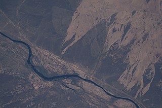
The Chu is a river in Northern Kyrgyzstan and Southern Kazakhstan. Of its total length of 1,067 kilometres (663 mi), the first 115 kilometres are in Kyrgyzstan, then for 221 kilometres the river serves as the border between Kyrgyzstan and Kazakhstan and the last 731 kilometres are in Kazakhstan. It is one of the longest rivers in Kyrgyzstan and in Kazakhstan. It has a drainage basin of 62,500 square kilometres (24,100 sq mi).
The Sarysu is a river in Karaganda, Turkistan and Kyzylorda Regions of Kazakhstan. It is 671 kilometres (417 mi) long, and has a drainage basin of 81,600 square kilometres (31,500 sq mi).

Betpak-Dala or Betpaqdala is a desert zone in the Ulytau, Karaganda, Turkestan and Zhambyl regions, Kazakhstan.

The Moiynkum Desert, is a desert in the Turkistan and Zhambyl regions of southern Kazakhstan.

Barakkol is a lake in Ulytau District, Ulytau Region, central Kazakhstan.

Shalkar is a brackish lake in Terekti District, West Kazakhstan Region, Kazakhstan.

Baitakkol, is a lake in Yrgyz District, Aktobe Region, Kazakhstan.

Shaglyteniz or Shagalalyteniz is a lake in Akkayin and Taiynsha districts, North Kazakhstan Region, Kazakhstan.

Teniz is a lake in Kamysty District, Kostanay Region, Kazakhstan.

Zharman is a salt lake in Naurzum District, Kostanay Region, Kazakhstan.

Karasor, is a salt lake in Karkaraly District, Karaganda Region, Kazakhstan.

Balyktykol is a lake in Karkaraly District, Karaganda Region, Kazakhstan.

Kyzylkol is a lake in Sozak District, Turkestan Region, Kazakhstan.

The Ashchykol Depression, is a depression in the Turkistan and Kyzylorda regions, Kazakhstan.

The Shieli-Telikol Canal, also known as "Shieli Canal" and "Telikol Canal", is an irrigation canal in the Kyzylorda Region, Kazakhstan. It connects the Telikol lakes with Shieli.

Teniz is a lake in Mendykara District, Kostanay Region, Kazakhstan.

Ashchykol is a salt lake group in the Kyzylorda and Turkistan regions, Kazakhstan.
Ashchykol is a salt lake in the Sarysu and Talas districts, Jambyl Region, Kazakhstan.

Akzhaykyn is a salt lake group in Sozak District, Turkistan Region, Kazakhstan.
Korgalzhyn is a lake in Korgalzhyn District, Akmola Region, Kazakhstan. Korgalzhyn is the main body of water of the Korgalzhyn group of lakes, which includes Birtaban, Sholakshalkar, Shalkar, Zhanybekshalkar, Uialyshalkar and Zhandyshalkar.


