
Warragamba Dam is a heritage-listed dam in the outer South Western Sydney suburb of Warragamba, Wollondilly Shire in New South Wales, Australia. It is a concrete gravity dam, which creates Lake Burragorang, the primary reservoir for water supply for the city of Sydney. The dam wall is located approximately 65 kilometres (40 mi) to the southwest of Sydney central business district, near the town of Wallacia.

Lake Vyrnwy is a reservoir in Powys, Wales, built in the 1880s for Liverpool Corporation Waterworks to supply Liverpool with fresh water. It flooded the head of the Vyrnwy valley and submerged the village of Llanwddyn.

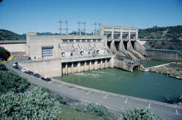
Khadakwasla Dam is a dam on the Mutha River 21 km (13 mi) from the centre of the city of Pune in Maharashtra, India. The dam created a reservoir known as Khadakwasla Lake which is the main source of water for Pune and its suburbs.

The Kolubara is a 87 km (54 mi) long river in western Serbia; it is an eastern, right tributary to the Sava river.
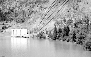
The Bridge River Power Project is a hydroelectric power development in the Canadian province of British Columbia, located in the Lillooet Country between Whistler and Lillooet. It harnesses the power of the Bridge River, a tributary of the Fraser, by diverting it through a mountainside to the separate drainage basin of Seton Lake, utilizing a system of three dams, four powerhouses and a canal.

Whiskeytown Lake is a reservoir in Shasta County in northwestern California, United States, about 8 miles (13 km) west of Redding. The lake is in the Whiskeytown Unit of the Whiskeytown-Shasta-Trinity National Recreation Area.
The Ub is a river in western Serbia, a 57 km-long right and longest tributary to Tamnava river.
The Ware River is a 35.4-mile-long (57.0 km) river in central Massachusetts. It has two forks, the both of which begin in Hubbardston, Massachusetts. The Ware River flows southwest through the middle of the state, joins the Quaboag River at Three Rivers, Massachusetts, to form the Chicopee River on its way to the Connecticut River.

Crab Creek is a stream in the U.S. state of Washington. Named for the presence of crayfish, it is one of the few perennial streams in the Columbia Basin of central Washington, flowing from the northeastern Columbia River Plateau, roughly 5 km (3.1 mi) east of Reardan, west-southwest to empty into the Columbia River near the small town of Beverly. Its course exhibits many examples of the erosive powers of extremely large glacial Missoula Floods of the late Pleistocene, which scoured the region. In addition, Crab Creek and its region have been transformed by the large-scale irrigation of the Bureau of Reclamation's Columbia Basin Project (CBP), which has raised water table levels, significantly extending the length of Crab Creek and created new lakes and streams.

Spring Creek Debris Dam is an earthfill dam on Spring Creek, a tributary of the Sacramento River, in Shasta County in the U.S. state of California. Completed in 1963, the dam, maintained by the U.S. Bureau of Reclamation, serves primarily to collect severe acid mine drainage stemming from the Iron Mountain Mine. The dam forms the Spring Creek Reservoir, less than 1 mile (1.6 km) long. Spring Creek and South Fork Spring Creek flow into the reservoir from a 16-square-mile (41 km2) watershed. The dam is directly upstream from the city of Keswick, California and the Keswick Reservoir. The operation is part of the Trinity River Division of the Central Valley Project.

Glen Canyon Dam, a concrete arch dam on the Colorado River in the American state of Arizona, is viewed as carrying a large amount of risk, most notably due to siltation. The Colorado and San Juan rivers deposit large volumes of silt into Lake Powell, slowly decreasing its capacity. The sediment will eventually build up against the dam and could affect its safe operation and lead to its failure.
The Oderteich is an historic reservoir about seven kilometres northeast of Sankt Andreasberg in the Upper Harz in central Germany. It was built by miners from St. Andreasberg in the years 1715 to 1722 and, today, is an important component of the water supply network known as the Upper Harz Water Regale. Moreover, for 170 years, from the time it was completed to the end of the 19th century, the Oderteich had the largest dam in Germany. The dam lies at a height of 725 m above NN by the B 242 federal highway, about a kilometre west of its intersection with the B 4.

Howard A. Hanson Dam is an earthen embankment dam on the Green River, 21 miles (34 km) east of Auburn, Washington. The dam was completed in 1961 and its primary purpose is flood control along with water supply for Tacoma, Washington.

John W. Flannagan Dam is a flood control dam located in the Cumberland Mountains of Dickenson County, Virginia. It forms the John W. Flannagan Reservoir behind it.

Majdan is a village in the municipality of Gornji Milanovac, Serbia. According to the 2002 census, the village has a population of 513 people.

Camanche Dam is an earthfill Dam on the Mokelumne River in the central California, about 20 mi (32 km) from East Lodi. The dam and reservoir lie in the Sierra Nevada foothills in San Joaquin County. Construction of Camanche Dam was started in 1963 and completed in 1964. East Bay Municipal Utilities District (EBMUD) owns and operates it. The purpose of Camanche Dam and reservoir is to provide flood control, water flows for agriculture, habitat for fisheries and recreation for community.
Keswick Dam is a concrete gravity dam on the Sacramento River about 2 miles (3.2 km) northwest of Redding, California. Part of the U.S. Bureau of Reclamation's Central Valley Project, the dam is 157 feet (48 m) high and impounds the Keswick Reservoir, which has a capacity of 23,800 acre⋅ft (29,400,000 m3). The dam's power plant has three turbines with a generating capacity of 117 megawatts (MW), which, in 1992, was uprated from its original 75 MW. The dam and reservoir serve as a forebay to regulate peaking power releases from the Shasta Dam upstream.
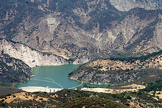
Gibraltar Dam is located on the Santa Ynez River, in southeastern Santa Barbara County, California, in the United States. Forming Gibraltar Reservoir, the dam is owned by the city of Santa Barbara. Originally constructed in 1920 and expanded in 1948, the dam and reservoir are located in a remote part of the Los Padres National Forest.

Between 13 and 18 May 2014 a low-pressure cyclone designated Tamara and Yvette affected a large area of Southeastern and Central Europe, causing floods and landslides. Serbia and Bosnia and Herzegovina suffered the greatest damage, as the rain was the heaviest in 120 years of recorded weather measurements. By 20 May, at least 62 people had died as a result of the flooding, and hundreds of thousands had been forced from their homes. Towns of Obrenovac in Serbia and Doboj in Bosnia and Herzegovina account for most victims, after being inundated by several-meter high waters from nearby rivers.
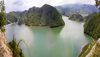
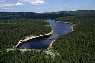
Rovni Lake is a water reservoir in western Serbia, created by damming the Jablanica river. It is located between the villages of Stubo and Rovni, 15 km (9.3 mi) from the city of Valjevo. The construction of the Stubo-Rovni dam was completed in September 2015. The lake is an integral part of the regional water management system "Rovni" providing water supply for several cities: Valjevo, Lazarevac, Lajkovac, Ub and Mionica.

