
Jagodina is a city and the administrative center of the Pomoravlje District in central Serbia. It is situated on the banks of the Belica River, in the geographical region of Šumadija. The city itself has a population of 43,311 inhabitants, while its administrative area comprises 76,712 inhabitants.
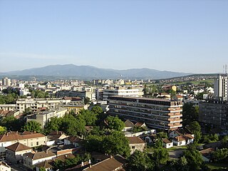
Kruševac is a city and the administrative center of the Rasina District in central Serbia. It is located in the valley of West Morava, on Rasina river. According to the 2011 census, the city administrative area has a population of 136,752 while the urban area has 81,316 inhabitants.

Požarevac is a city and the administrative centre of the Braničevo District in eastern Serbia. It is located between three rivers: Danube, Great Morava and Mlava and below the hill Čačalica (208m). As of 2011, the city has a population of 44,183 while the city administrative area has 75,334 inhabitants.

Vršac is a city and the administrative centre of the South Banat District in the autonomous province of Vojvodina, Serbia. As of 2011, the city urban area had a population of 35,701, while the city administrative area had 52,026 inhabitants. It is located in the geographical region of Banat.

Krupanj is a town and municipality located in the Mačva District of western Serbia. The municipality has a total population of 17,295 inhabitants, while the town has a population of 4,429 inhabitants.

Cetingrad is a municipality in Karlovac County, Croatia near Croatia's border with Bosnia. The population of the village itself is 319, while the total municipality population is 2,027 (2011). The municipality is part of Kordun. Cetingrad is underdeveloped municipality which is statistically classified as the First Category Area of Special State Concern by the Government of Croatia.
Srbobran is a town and municipality located in the South Bačka District of the autonomous province of Vojvodina, Serbia. The town is located on the north bank of the Danube-Tisa-Danube canal. The town has a population of 12,009, and the municipality of 16,317.

Bela Crkva is a town and municipality located in the South Banat District of the autonomous province of Vojvodina, Serbia. The town has a population of 8,868, while the Bela Crkva municipality has 17,285 inhabitants.
The Kingdom of Serbia was a country located in the Balkans which was created when the ruler of the Principality of Serbia, Milan I, was proclaimed king in 1882. Since 1817, the Principality was ruled by the Obrenović dynasty. The Principality, under the suzerainty of the Ottoman Empire, de facto achieved full independence when the last Ottoman troops left Belgrade in 1867. The Congress of Berlin in 1878 recognized the formal independence of the Principality of Serbia, and in its composition Nišava, Pirot, Toplica and Vranje districts entered the South part of Serbia.
Banatsko Novo Selo is a village located in the municipality of Pančevo, South Banat District, Vojvodina, Serbia. The village has a Serb ethnic majority and its population numbering 7,089 people.

Udbina is a village and a municipality in historical Krbava, in the Lika region of Croatia. It is administratively a part of the Lika-Senj County.

Most of the territory of what is now the Republic of Serbia was part of the Ottoman Empire throughout the Early Modern period, especially Central Serbia and Southern Serbia, unlike Vojvodina which had passed to Habsburg rule starting from the end of the 17th century.

Lajkovac is a town and municipality located in the Kolubara District of western Serbia. As of 2011, it has population of 3,249 inhabitants, while the municipality has 15,475 inhabitants.
Banatski Brestovac is a village located in the Municipality of Pančevo, in the South Banat District of Serbia. It is situated in the Autonomous Province of Vojvodina. The village has a Serbian ethnic majority and its population numbers 3,251 people.

Trstenik is a town and municipality located in the Rasina District of central Serbia. As of 2011 census, the town has 15,329, while the municipality has 42,989 inhabitants. It lies on the West Morava river.

Ostrovo is a village in the municipality of Kostolac, city of Požarevac, Serbia. According to the 2002 census, the village has a population of 685 people.
Rogača is a village in the municipality of Sopot, Serbia. According to the 2002 census, the village has a population of 1046 people. It is the birthplace of one of the leaders of the First Serbian Uprising, Janko Katić.

The Rakovica Monastery is the monastery of the Serbian Orthodox Church, within the Archbishopric of Belgrade and Karlovci, located in the municipality of Rakovica in Belgrade, the capital of Serbia. It is dedicated to the archangels Michael and Gabriel.

The Church of the Ascension is a Serbian Orthodox church in downtown Belgrade, the capital of Serbia. It still uses the bell under which the Hatisheriff of 1830 was announced, by which the Ottoman Empire granted autonomy to Serbia. The church was declared a cultural monument in 1969.

The St. Mark's Church is a church in the town of Užice, in western Serbia. It is noted for its appearance, as an old, small, mostly wooden church in the town's modern urban setting. Originally constructed in 1721, it was rebuilt in 1828 and is the oldest surviving church in the entire Užice region. It was protected by the state in 1951 and declared a Cultural Monument of Great Importance in 1987. The church is colloquially called by the residents the Small Užice Church.

