
Avala is a mountain in Serbia, overlooking Belgrade. It is situated in the south-eastern corner of the city and provides a great panoramic view of Belgrade, Vojvodina and Šumadija, as the surrounding area on all sides is mostly lowlands. It stands at 511 metres (1,677 ft) above sea level, which means that it enters the locally defined mountain category just by 11 m (36 ft).

Đerdap National Park stretches along the right bank of the Danube River from the Golubac Fortress to the dam near Novi Sip, Serbia. It was established in 1974 and spreads on 63,786.5 ha. The park management office is in the town of Donji Milanovac on the Danube. Across the river is the Parcul Natural Porțile de Fier in Romania.

Kosjeríć is a town and municipality located in the Zlatibor District of western Serbia. The municipality has a population of 12,090 inhabitants, but the town itself has 3,992. The municipality's area is 359 square kilometres (139 sq mi), with 26 villages mostly placed in the river valleys, though there are also some settlements in the mountains at altitudes of more than 1,000 metres.

Lajkovac is a town and municipality located in the Kolubara District of western Serbia. As of 2011, it has population of 3,249 inhabitants, while the municipality has 15,475 inhabitants.

Sava Savanović is one of the most famous vampires in Balkan and Serbian folklore.

The Stopića Cave is a limestone cave near Sirogojno, on the slopes of Mount Zlatibor in western Serbia. It has been protected by the state as a natural monument. By 2022 it became the most visited cave in Serbia.

Maljen is a mountain in western Serbia, just south of the city of Valjevo. It is well known as a summer and winter resort. The highest peak is Kraljev Sto, at 1,104 m (3,622 ft) above sea level, followed by Crni Vrh at 1,096 m (3,596 ft). On Maljen is situated resort Divčibare with 3 hotels, 24 holiday camps, two mountain lodges and two ski trails. During summer the slopes of the mountain are covered with flower meadows with white daffodils.
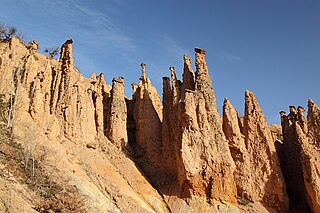
Đavolja varoš is a rock formation consisting of about 200 earth pyramids or "towers", located in southern Serbia on the Radan Mountain, in the municipality of Kuršumlija. There are several similar geological formations in the world, but Đavolja Varoš has the most numerous and the tallest "towers".

Gardoš is an urban neighborhood of Belgrade, the capital of Serbia. It is located in Belgrade's municipality of Zemun. Located on the slopes of the hill of the same name, with its tower and preserved old architecture, Gardoš is the major historical landmark of Zemun. Remnants of the Gardoš Fortress, built in the 14th century and the 15th century, are the oldest surviving parts of Zemun.

Kosmaj is a mountain south of Belgrade. With an elevation of 626 meters, it is the highest point of the entire Belgrade City area and is nicknamed one of two "Belgrade mountains".

Povlen is a mountain in western Serbia, located thirty kilometers west of Valjevo. It has several peaks, the three most important being Small Povlen, Middle Povlen and Big Povlen, which is, ironically, the lowest.

Zarožje is a village in the municipality of Bajina Bašta, in western Serbia. Located on the slopes of the Povlen mountain, Zarožje has abundance of forests and meadows, and developed agriculture and husbandry. The village, and one of its features, the watermill, are best known as the inspiration for Milovan Glišić's 1880 short story After ninety years. It featured Sava Savanović, the most famous vampire in Serbian folklore. The story was filmed in 1973 as one of the most popular Serbian horror films, Leptirica.

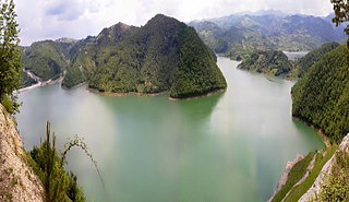
Lake Perućac is an artificial lake on the Drina River, on the border between Bosnia and Herzegovina and Serbia. It was created in 1966 and occupies a natural bend of the river, which encircles the Tara mountain, between towns of Višegrad in Bosnia and Bajina Bašta in Serbia.

Kučaj is a mountain range in eastern Serbia. Its highest peak, Velika Tresta has an elevation of 1,284 meters above sea level. They belong to the Serbian extension of Carpathians, which separate the valleys of Great Morava and Timok.
Miroč is a mountain in eastern Serbia, between the towns of Donji Milanovac and Tekija. Its highest peak Štrbac has an elevation of 768 meters (2,520 ft) above sea level. Along with Liškovac, it is part of the Iron Gate gorge of the Danube river. It is located in the Đerdap national park.

Ozren is a mountain in central Serbia, near the town of Sokobanja. Its highest peak, Leskovik, has an elevation of 1,178 m (3,865 ft). Ozren is well-forested and attractive as a picnic ground for visitors to the Soko Banja.
Rovni Lake is a water reservoir in western Serbia, created by damming the Jablanica river. It is located between the villages of Stubo and Rovni, 15 km (9.3 mi) from the city of Valjevo. The construction of the Stubo-Rovni dam was completed in September 2015. The lake is an integral part of the regional water management system "Rovni" providing water supply for several cities: Valjevo, Lazarevac, Lajkovac, Ub and Mionica.

Vladimir Pecikoza is a Serbian archaeologist and Head of the Archaeology Department at the Petnica Science Center.
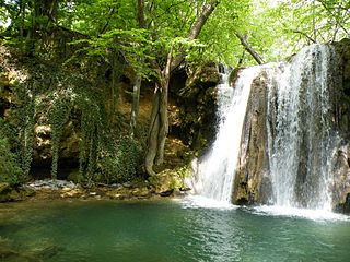
The Blederija is a natural monument in eastern Serbia. It was placed under the state protection as the geological phenomenon and includes various geological formations in the watershed of the Blederija river, on the Miroč mountain.


