A defter was a type of tax register and land cadastre in the Ottoman Empire.

Tsaritsani or Tsiaritsiani is a village and a community of the Elassona municipality. Before the 2011 local government reform, it was an independent community. The 2011 census recorded 2,040 inhabitants in the village. The community of Tsaritsani covers an area of 57.791 km2.

Livadi or Leivadi is an Aromanian village and a former municipality in the Larissa regional unit, Thessaly, Greece. Since the 2011 local government reform it is part of the municipality Elassona, of which it is a municipal unit.

Klisanski breg, also known as Gornje Sajlovo and Šumice, is an urban neighborhood of the city of Novi Sad, Serbia.

Leskovdol is a mountainous village in Bulgaria situated in Golema mountain, part of the Balkan mountain range. It is located 45 kilometers north from Sofia and is part of the Svoge municipality. According to the 2011 census 114 people live in the settlement. Several places of interest are located nearby including the Seven Altars monastery, Izdremets peak and a section of the Kom–Emine long-distance footpath.
The Resm-i Çift was a tax in the Ottoman Empire. It was a tax on farmland, assessed at a fixed annual rate per çift, and paid by land-owning Muslims. Some Imams and some civil servants were exempted from the resm-i çift.
The resm-i mücerred was a bachelor tax in the Ottoman Empire, related to the resm-i çift and the resm-i bennâk.
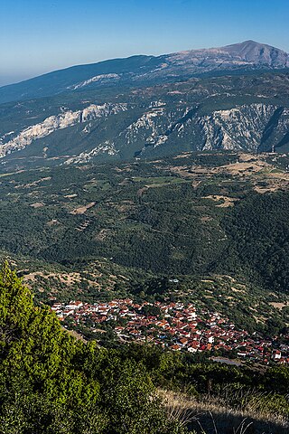
Rapsani is a town of the former municipal district of Kato Olympos, which is part of the municipality of Tempi in the Larissa regional unit, Thessaly, Greece.
Sparmos is a village of the Elassona municipality. Before the 2011 local government reform it was a part of the municipality of Olympos. The 2011 census recorded 126 inhabitants in the village. Sparmos is a part of the community of Olympiada.
Valanida is a village and a community of the Elassona municipality. Before the 2011 local government reform it was part of the municipality of Elassona, of which it was a municipal district. The 2011 census recorded 450 inhabitants in the village and 559 in the community. The community of Valanida covers an area of 58.354 km2.
Loutro is a village and a community of the Elassona municipality. Before the 2011 local government reform, Loutro was part of the municipality of Antichasia, of which it was a municipal district and the seat. The 2011 census recorded 702 inhabitants in the village. The community of Loutro covers an area of 29.165 km2.
Kokkinopilos is an Aromanian village and a community of the Elassona municipality. Before the 2011 local government reform it was a part of the municipality of Olympos. The 2011 census recorded 125 inhabitants in the village and 592 inhabitants in the community. The community of Kokkinopilos covers an area of 129.368 km2.
Kokkinogeio is a village and a community of the Elassona municipality. Before the 2011 local government reform it was a part of the municipality of Olympos, of which it was a municipal district. The 2011 census recorded 240 inhabitants in the village. The community of Kokkinogeio covers an area of 9.902 km2.
Vlachogianni is an Aromanian village and a community of the Elassona municipality. Before the 2011 local government reform it was a part of the municipality of Potamia, of which it was a municipal district and the seat. The 2011 census recorded 895 inhabitants in the village. The community of Vlachogianni covers an area of 33.974 km2.
Giannota is a village and a community of the Elassona municipality. Before the 2011 local government reform it was a part of the municipality of Sarantaporo, of which it was a municipal district. The 2011 census recorded 261 inhabitants in the village. The community of Giannota covers an area of 26.989 km2.
Lykoudi is a village and a community of the Elassona municipality. Before the 2011 local government reform it was a part of the municipality of Sarantaporo, of which it was a municipal district. The 2011 census recorded 298 inhabitants in the village. The community of Lykoudi covers an area of 20.784 km2.
Lygaria is a village in the municipality of Tyrnavos. Before 1966 it was a part of the community of Argyropouli. The 2011 census recorded 56 inhabitants in the village. Lygaria is a part of the community of Tyrnavos.

Trieshi is a historical Albanian tribe (fis) and region in Montenegro above the right bank of the Cem river near the Albanian border in Tuzi Municipality. It is part of the region of Malësia.

Bardovci is a village in the municipality of Karpoš, North Macedonia.
The Cadastre Bureau was an Ottoman Empire agency. The bureau served as a registry of real estate, but did not classify any land themselves. George Young, author of Corps de droit ottoman, wrote that the common French translation was "Bureau de Cadastre", but he labeled it as the Ministry of the Cadastre.