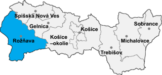
Markuška is a village and municipality in the Rožňava District in the Košice Region of middle-eastern Slovakia.

Püspökszilágy is a village in Pest county, Hungary.

Duchów is a village in the administrative district of Gmina Dobre, within Mińsk County, Masovian Voivodeship, in east-central Poland. It lies approximately 4 kilometres (2 mi) east of Dobre, 19 km (12 mi) north-east of Mińsk Mazowiecki, and 52 km (32 mi) east of Warsaw.
Dolní Slivno is a village and municipality in Mladá Boleslav District in the Central Bohemian Region of the Czech Republic.
Vichovo is a village in General Toshevo Municipality, Dobrich Province, in northeastern Bulgaria.
Kurista is a village in Jõgeva Parish, Jõgeva County in eastern Estonia.
Palasi is a village in Vinni Parish, Lääne-Viru County, in northeastern Estonia.

Makovište is a village in the municipality of Kosjerić, western Serbia. According to the 2002 census, the village has a population of 893 people.
Dragijevica is a village located in Osečina Municipality, Kolubara District, Serbia.
Lopatanj is a village located in Osečina Municipality, Kolubara District, Serbia.
Beloševac is a village in the municipality of Valjevo, Serbia. According to the 2002 census, the village has a population of 849 people.
Beomužević is a village in the municipality of Valjevo, Serbia. According to the 2002 census, the village has a population of 528 people.
Donje Leskovice is a village in the municipality of Valjevo, Serbia. According to the 2002 census, the village has a population of 597 people.
Jasenica is a village in the municipality of Valjevo, Serbia. According to the 2002 census, the village has a population of 427 people.
Klanica is a village in the municipality of Valjevo, Serbia. According to the 2002 census, the village has a population of 590 people.
Kozličić is a village in the municipality of Valjevo, Serbia. According to the 2002 census, the village has a population of 237 people.
Loznica is a village in the municipality of Valjevo, Serbia. According to the 2002 census, the village has a population of 660 people.
Mrčić is a village in the municipality of Valjevo, Serbia. According to the 2002 census, the village has a population of 192 people.
Sušica is a village in the municipality of Valjevo, Serbia. According to the 2002 census, the village has a population of 301 people.
Zabrdica is a village in the municipality of Valjevo, Serbia. According to the 2002 census, the village has a population of 462 people.

 village Stapar - Panorama
 village Stapar - Panorama
 village Stapar - Panorama
 village Stapar - Panorama
 village Stapar - Panorama
 village Stapar - Panorama
 village Stapar - Panorama


