Kétegyháza is a large village in Békés County, in the Southern Great Plain region of south-east Hungary. It is one of the main centres of Hungary's Romanian minority.
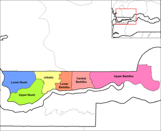
Jokadu is one of the six districts of the North Bank Division of the Gambia.

Szewce Owsiane is a village in the administrative district of Gmina Bedlno, within Kutno County, Łódź Voivodeship, in central Poland. It lies approximately 13 kilometres (8 mi) south-east of Kutno and 45 km (28 mi) north of the regional capital Łódź.
Stojadła is a village in the administrative district of Gmina Mińsk Mazowiecki, within Mińsk County, Masovian Voivodeship, in east-central Poland. It lies approximately 3 kilometres (2 mi) west of Mińsk Mazowiecki and 37 km (23 mi) east of Warsaw.

Vukosavci is a village in the municipality of Aranđelovac, Serbia. According to the 2002 census, the village has a population of 411 people.
Svračkovci is a village in the municipality of Gornji Milanovac, Serbia. According to the 2011 census, the village has a population of 462 inhabitants.
Lähtse is a village in Vinni Parish, Lääne-Viru County, in northeastern Estonia.

Kiisamaa is a village in Lääneranna Parish, Pärnu County in southwestern Estonia.

Bogovađa is a village situated in Lajkovac municipality, Kolubara District in Serbia.

Ćelije is a village situated in Lajkovac municipality, Kolubara District in Serbia.

Struganik is a village situated in Mionica municipality in Serbia and the birthplace of Field Marshal Živojin Mišić.
Donje Jarušice is a village in the municipality of Rača, Serbia. According to the 2002 census, the village has a population of 265 people.
Masloševo is a village in the municipality of Stragari, Serbia. According to the 2002 census, the village has a population of 478 people.
Guriševci is a village in the municipality of Topola, Serbia. According to the 2002 census, the village has a population of 153 people.
Jarmenovci is a village in the municipality of Topola, Serbia. According to the 2002 census, the village has a population of 563 people.
Svetlić is a village in the municipality of Topola, Serbia. According to the 2002 census, the village has a population of 417 people.
Vojkovci is a village in the municipality of Topola, Serbia. According to the 2002 census, the village has a population of 278 people.

Lončanik is a village in the municipality of Ub, Serbia. According to the 2011 census, the village has a population of 477 people.
Kilözü is a village in the Mudurnu district of Bolu province in Turkey.

