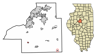
Green Valley is a village in Tazewell County, Illinois, United States. It is south of Pekin near the county border along Illinois State Route 29. The population was 709 at the 2010 census
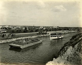
The Miami Canal, or C-6 Canal, flows from Lake Okeechobee in the U.S. state of Florida to its terminus at the Miami River, which flows through downtown Miami. The canal flows in a south and southeasterly direction for approximately 77 miles, and passes through three counties: Broward, Palm Beach, and Miami-Dade. It was constructed in the early part of the 20th century to drain the Everglades Agricultural Area (EAA). Removing the canal was proposed as part of the Restoration of the Everglades.

Solniczki is a village in the administrative district of Gmina Juchnowiec Kościelny, within Białystok County, Podlaskie Voivodeship, in north-eastern Poland. It lies approximately 7 kilometres (4 mi) north-east of Juchnowiec Kościelny and 7 km (4 mi) south-east of the regional capital Białystok.

Miejskie Nowiny is a village in the administrative district of Gmina Sokółka, within Sokółka County, Podlaskie Voivodeship, in north-eastern Poland, close to the border with Belarus. It lies approximately 7 kilometres (4 mi) west of Sokółka and 34 km (21 mi) north-east of the regional capital Białystok.

Pirəköcə is a village and municipality in the Kurdamir Rayon of Azerbaijan.
Ərəbxana is a village and municipality in the Kurdamir Rayon of Azerbaijan.
Qədimkənd is a village and municipality in the Neftchala Rayon of Azerbaijan. It has a population of 2,320. The municipality consists of the villages of Qədimkənd and Birinci Qaralı.
Gawerków is a village in the administrative district of Gmina Żelechlinek, within Tomaszów Mazowiecki County, Łódź Voivodeship, in central Poland. It lies approximately 3 kilometres (2 mi) east of Żelechlinek, 23 km (14 mi) north of Tomaszów Mazowiecki, and 42 km (26 mi) east of the regional capital Łódź.

Wygoda is a village in the administrative district of Gmina Kurów, within Puławy County, Lublin Voivodeship, in eastern Poland.

Jodłówka-Wałki is a village in the administrative district of Gmina Tarnów, within Tarnów County, Lesser Poland Voivodeship, in southern Poland.
Mościska Małe is a village in the administrative district of Gmina Radoszyce, within Końskie County, Świętokrzyskie Voivodeship, in south-central Poland. It lies approximately 5 kilometres (3 mi) east of Radoszyce, 17 km (11 mi) south-west of Końskie, and 30 km (19 mi) north-west of the regional capital Kielce.
Zarat is a village in the Ismailli Rayon of Azerbaijan. The village forms part of the municipality of Çandahar.
Łyczba is a village in the administrative district of Gmina Łubnice, within Staszów County, Świętokrzyskie Voivodeship, in south-central Poland. It lies approximately 2 kilometres (1 mi) east of Łubnice, 17 km (11 mi) south of Staszów, and 66 km (41 mi) south-east of the regional capital Kielce.

Bieniędzice is a village in the administrative district of Gmina Wolanów, within Radom County, Masovian Voivodeship, in east-central Poland.
Nacław is a village in the administrative district of Gmina Kościan, within Kościan County, Greater Poland Voivodeship, in west-central Poland. It lies approximately 3 kilometres (2 mi) south of Kościan and 42 km (26 mi) south-west of the regional capital Poznań.
Janinów is a village in the administrative district of Gmina Rudniki, within Olesno County, Opole Voivodeship, in south-western Poland. It lies approximately 3 kilometres (2 mi) north-east of Rudniki, 25 km (16 mi) north-east of Olesno, and 65 km (40 mi) north-east of the regional capital Opole.
Święty Kamień is a village in the administrative district of Gmina Barciany, within Kętrzyn County, Warmian-Masurian Voivodeship, in northern Poland, close to the border with the Kaliningrad Oblast of Russia. It lies approximately 12 kilometres (7 mi) north of Barciany, 26 km (16 mi) north of Kętrzyn, and 84 km (52 mi) north-east of the regional capital Olsztyn.

Dobrovodica is a village in the municipality of Batočina, Serbia. According to the 2011 census, the village has a population of 381 people.

Saint-Christophe is a railway station in Saint-Christophe-Vallon, Aveyron, Occitanie, France. The station is on the Capdenac–Rodez railway line. The station is served by Lunéa and TER (local) services operated by SNCF.

Charentsavan City Stadium, is a multipurpose stadium in Charentsavan, Armenia, mainly used for football games, as well as local events of athletics.

