
Kukës County is a landlocked county in northeastern Albania, with the capital in Kukës. The county spans 2,374 square kilometres (917 sq mi) and had a total population of 61,998 people as of 2021. The county borders on the counties of Dibër, Lezhë and Shkodër and the countries of Montenegro, Kosovo and North Macedonia. It is divided into three municipalities: Has, Kukës and Tropojë. The municipalities are further subdivided into 290 towns and villages in total.

Shkodër County is a county in northwestern Albania, with the capital in Shkodër. The county spans 3,562 square kilometres (1,375 sq mi) and had a total population of 154,479 people as of the 2023 census. The county borders on the counties of Lezhë, Kukës and the country of Montenegro. The county consists of five municipalities: Fushë-Arrëz, Malësi e Madhe, Pukë, Shkodër and Vau i Dejës.

The Drin is a river in Southeastern Europe with two major tributaries – the White Drin and the Black Drin and two distributaries – one discharging into the Adriatic Sea, in the Gulf of Drin and the other into the Bojana River. Its catchment area extends across Albania, Kosovo, Serbia, Greece, Montenegro and North Macedonia and is home to more than 1.6 million people. The river and its tributaries form the Gulf of Drin, an ocean basin that encompasses the northern Albanian Adriatic Sea Coast.

Prende or Premte is the dawn goddess, goddess of love, beauty, fertility, health and protector of women, in the Albanian pagan mythology. She is also called Afër-dita, an Albanian phrase meaning "near day", "the day is near", or "dawn", in association with the cult of the planet Venus, the morning and evening star. She is referred to as Zoja Prenne or Zoja e Bukuris. Her sacred day is Friday, named in Albanian after her: e premte, premtja. She reflects features belonging to the original Indo-European dawn goddess. A remarkable reflection associated with the Indo-European dawn goddess is the Albanian tradition according to which Prende is the daughter of the sky god – Zojz.
Franz Jozeph Island was an island located at the mouth of the Buna river in Albania.

Fierzë is a town and a former municipality in the Kukës County, northern Albania. At the 2015 local government reform it became a subdivision of the municipality Tropojë. Fierzë sits on the right, northern bank of the Drin, opposite the village Fierzë in Fushë-Arrëz municipality.

Vau i Dejës, English: Deja's Ford, is a town and a municipality in Shkodër County, northwestern Albania. It was formed at the 2015 local government reform by the merger of the former municipalities Bushat, Hajmel, Shllak, Temal, Vau i Dejës, and Vig-Mnelë, that became municipal units. The seat of the municipality is the town Vau i Dejës. The total population is 30,438, in a total area of 499.35 km2. The population of the former municipality at the 2011 census was 8,117.
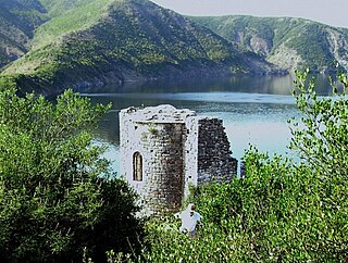
Shurdhah is an island in northern Albania in the Vau i Dejës Reservoir. It was formed after the flooding of the Drin river valley during the construction of the HPS. It is the largest island in the reservoir with an area of 7.5 hectares. From the most northern tip of the island to the most southern tip of it, it has an estimated length of 390 m (1,280 ft). It is accessible by tourist boat in summer from the Vau i Dejës dam or Rragam. Shurdhah is attested in medieval sources as Sarda and its submerged area was an early medieval settlement in Albania linked to the Komani-Kruja culture.
Stillo Islet or Stil Islet is a small islet located in Xarrë, southern Albania, on the Ionian Sea.
Shaqarí Islet is a small islet found in northern Albania in Lake Skadar.

Kune Island is an island located off the coast of Albania in the Adriatic Sea. The island lies in the delta of the river Drin near the city of Lezha and has an area of 1.4 square kilometres (0.5 sq mi). The island is 1.5 kilometres from the coast. Kune island features extravagant and varied plant life, including plants such as small Mediterranean shrubs to ash and willow forests. Wildlife is abundant as well. The island is home to around seventy species of birds, twenty-two species of reptiles, six species of amphibians and twenty-three species of mammals.
Koman is a settlement in the former Temal municipality, Shkodër County, northern Albania. At the 2015 local government reform it became part of the municipality Vau i Dejës. The Koman Hydroelectric Power Station and lake Koman have taken the name of the settlement.

Lake Koman Ferry is a passenger ferry service operated by several local companies along the Koman Reservoir in Northern Albania.

Berisha is a historical Albanian tribe (fis) and region in Pukë, northern Albania. Berisha is one of the oldest documented Albanian tribes, first recorded in 1242 in Dulcigno. In the Middle Ages, it was widely spread across northern Albania, southern Montenegro and Kosovo. People who traced their origin to Berisha are also found in the coastal trading hubs of Dalmatia in the Middle Ages. Berisha formed its own territorial community in Pukë in the course of the 14th century.
Hajro Ulqinaku is an Albanian writer from Ulcinj, Montenegro.

Osum Island (Albanian: Ishulli i Osumit) is an island in south-central of Albania, in the Osum river, in the city of Berat.
Faruk Myrtaj is an Albanian novelist, poet, translator and engineer. Myrtaj was born in a small mining town in Vlora. He was deprived the right for higher education (University) because of the communist regime, then in power. Only after 9 year was given to him the possibility to continue University, in the Mining Engineering Faculty of the University of Tirana, where he graduated in 1988.

The Shalë or Lumi i Shalës is a river flowing inside the Albanian Alps in northern Albania. Its source is near the village of Theth, close to the border with Montenegro in the Alps of Albania National Park. It drains the central part of the alps to the south and flows into the artificially dammed Drin as lake Koman near the village Telum.
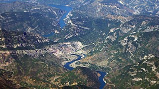
Lake Koman is a reservoir on the Drin River in northern Albania. Lake Koman is surrounded by dense forested hills, vertical slopes, deep gorges, and a narrow valley, completely taken up by the river. Besides the Drin, it is fed by the Shala and Valbona Rivers. The lake stretches in an area of 34 km2 (13 sq mi), its width being 400 m (0.25 mi). The narrowest gorge, which is surrounded by vertical canyon walls, is more than 50 m (0.031 mi) wide. The reservoir was constructed between 1979 and 1988 near the village of Koman with a height of 115 m (377 ft).

Pelican Island is a small island located within the confines of the Karavasta Lagoon, in the municipality of Divjakë, western Albania.
