Nemunas Delta

Last updated
Nemunas Delta
Atmata River.jpg
Atmata River
Location Lithuania
Area28,952 ha (71,540 acres)
Designated20 August 1993
Reference no.629 [1]

Nemunas Delta is the Lithuanian name for the Neman (Nemunas) River Delta, in Lithuania. Prior to post-World War II border changes, it was known in German as the Memel Niederung, as the Neman was for centuries called the Memel in German.

Contents

When it reaches the Baltic Sea, the Neman splits into a maze of river branches and canals, forming polders and wetlands that make it a very attractive destination for eco-tourism. The four main distributaries are Atmata, Pakalnė, Skirvytė and Gilija. In the centre of the delta lies Lithuania's largest island, Rusnė Island (5 km²), and its eponymous village. Although it is the largest human settlement in the delta, its population is only about 2,500.

Delta

The Nemunas Delta wetlands are considered globally significant and are protected under the Ramsar Convention. To safeguard the delta's wildlife and facilitate research, the Nemunas Delta Regional Park [2] was created in 1992. It covers 239.5 km² and consists of 14 reserves and one water reservoir. About 20% of the area is covered by water. Since 1999, the Lithuanian Society of Ornithologists [3] and the Nemunas Delta Regional Park Administration have been organizing bird counts every October. The rally is an open, international, and non-professional attempt to tally as many bird species as possible. Bird counts assist in identifying environmental threats to the well-being of birds or, conversely, in assessing the outcomes of environmental management initiatives intended to ensure the survival of at-risk species or encourage the breeding of species for aesthetic or ecological reasons. The delta undergoes annual flooding, but the greatest threats to its integrity are posed by pollution, agriculture, the fishing industry, and tourism.

The delta hosts many rare varieties of birds during the spring breeding season (the total reported number of species is about 200; about 40 species are listed in the Lithuanian Red Book of Endangered Species). It is also the most important layover for migrating birds in Lithuania. Millions of birds and hundreds of species travel through this area each year, including some internationally endangered species: the white-tailed eagle, the barnacle goose, cranes, dunlins and aquatic warblers. The principal research facilities are located in Ventė Cape (Lithuanian : Ventės ragas, sometimes referred to as the Ventė Peninsula). One of the first bird ringing stations in Europe was opened there in 1929 by a Lithuanian zoologist, Tadas Ivanauskas. Birds ringed at the Cape have been found migrating to Iran, Egypt and even to the Republic of South Africa.

Mammals found in the delta include fox, beaver, elk, wild boar and otter.

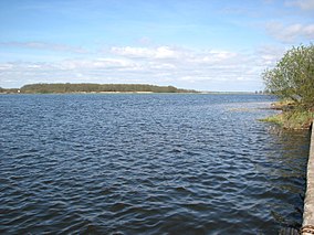
Another of the delta's special features is Lake Krokų Lanka (near where the Nemunas debouches), which formed when the river's outwash separated it from the Curonian Lagoon. It is the largest lake in the delta region, covering 7.93 km², and the only lake of marine origin in Lithuania.

Cape Vente.jpg
Ventė Cape, formerly Windenburg, in autumn morning, Heligoland traps visible

Kursenieki

Curonian-populated area in 1649 Curonians kursenieki in 1649.png
Curonian-populated area in 1649

While today the Kursenieki, also known as Kuršininkai are a nearly extinct Baltic ethnic group living along the Curonian Spit, in 1649 Kuršininkai settlement spanned from Memel (Klaipėda) to Danzig (Gdańsk). The Kuršininkai were eventually assimilated by the Germans, except along the Curonian Spit where some still live. The Kuršininkai were considered Latvians until after World War I when Latvia gained independence from the Russian Empire, a consideration based on linguistic arguments. This was the rationale for Latvian claims over the Curonian Spit, Memel, and other territories of East Prussia which would be later dropped.

Maps

Related Research Articles

<span class="mw-page-title-main">Geography of Lithuania</span>

Lithuania is a country in the Baltic region of Europe. The most populous of the Baltic states, Lithuania has 262 km (163 mi) of coastline consisting of the continental coast and the "Curonian Spit" coast. Lithuania's major warm-water port of Klaipėda (Memel) lies at the narrow mouth of Curonian Lagoon, a shallow lagoon extending south to Kaliningrad and separated from the Baltic sea by Curonian Spit, where Kuršių Nerija National Park was established for its remarkable sand dunes.

<span class="mw-page-title-main">Neman</span> River in Northeast Europe

The Neman,Niemen, Nioman, Nemunas or Memel is a river in Europe that rises in central Belarus and flows through Lithuania then forms the northern border of Kaliningrad Oblast, Russia's western exclave, which specifically follows its southern channel. It drains into the Curonian Lagoon, narrowly connected to the Baltic Sea. It flows about 937 km (582 mi), so is considered a major Eastern European river. It flows generally west to Grodno within 12 kilometres (7.5 mi) of the Polish border, north to Kaunas, then westward again to the sea.

<span class="mw-page-title-main">Gdańsk Bay</span> Bay in the Baltic Sea adjoining the port of Gdańsk and stretching to Kaliningrad

Gdańsk Bay or the Gulf of Gdańsk is a southeastern bay of the Baltic Sea. It is named after the adjacent port city of Gdańsk in Poland.

<span class="mw-page-title-main">Curonian Spit</span> Sand dune spit on the Baltic

The Curonian (Courish) Spit is a 98-kilometre (61 mi) long, thin, curved sand-dune spit that separates the Curonian Lagoon from the Baltic Sea. Its southern portion lies within Kaliningrad Oblast, Russia, and its northern within southwestern Klaipėda County, Lithuania. It is a UNESCO World Heritage Site shared by Lithuania and Russia.

<span class="mw-page-title-main">Klaipėda County</span> County of Lithuania

Klaipėda County is one of ten counties in Lithuania, bordering Tauragė County to the southeast, Telšiai County to the northeast, Kurzeme in Latvia to the north, and Kaliningrad Oblast in Russia to the south. To the west is the Baltic Sea. It lies in the west of the country and is the only county to have a coastline and not be landlocked. Its capital is Klaipėda. On 1 July 2010, the county administration was abolished, and since that date, Klaipėda County remains as the territorial and statistical unit.

<span class="mw-page-title-main">Šilutė District Municipality</span> Municipality in Lithuania Minor/ Samogitia, Lithuania

Šilutė District Municipality is one of 60 municipalities in Lithuania. It is known for spring floods when ice on Nemunas River starts melting. This is the only municipality in Lithuania that gets flooded on regular basis.

<span class="mw-page-title-main">Ventė Cape</span> Cape in Lithuania

Ventė Cape, sometimes referred to as Ventė Horn or Ventė Peninsula, is a headland in the Nemunas Delta, in Šilutė district, Lithuania. It is known as a resting place for birds during their migration, particularly in autumn. Ventė Cape Ornithological Station – one of the first bird ringing stations in Europe still in operation – was opened here by Tadas Ivanauskas in 1929.

<span class="mw-page-title-main">Rambynas Regional Park</span>

Rambynas Regional Park is one of the Regional Parks in Lithuania, situated at Pagėgiai municipality on the right Nemunas river bend in Lithuanian Republic near the border of Kaliningrad Oblast. The park was founded in 1992 with its area of 4,786 ha.

... Life is a constant movement. A Wide variety of different forms emerge and disappear... Over the thousand years, stones grow and decay. Life explodes, animals and people are born and so lost... These days, people learn how to look at nature at more calmed glance. And life effects are clearly visible in a strong relationship with nature as if the person opens the whole mystery of nature, all of the Mysteries...

The Kursenieki are a nearly extinct Baltic ethnic group living along the Curonian Spit. "Kuršiai" refers only to inhabitants of Lithuania and former East Prussia that speak a southwestern dialect of Latvian. Some autochthonous inhabitants of Šventoji in Lithuania call themselves "kuršiai" as well.

<span class="mw-page-title-main">Minija (village)</span> Village in Lithuania Minor, Lithuania

Minija or Mingė is a small fishermen's village in Šilutė District Municipality, Lithuania on Minija river, and is part of Nemunas Delta Regional Park. This village is unique in Lithuania as the main "road" is the river. Houses are situated on both banks and there is no bridge to connect them. The only way to get around is to use a boat. In 1997 it had 48 residents.

<span class="mw-page-title-main">Żuławy Wiślane</span> River delta of the Vistula

Żuławy Wiślane, in English known as the Vistula Fens, is the alluvial delta area of the river Vistula, in the northern part of Poland. It is a flat and deforested region comprising wetlands and agricultural plains that cover approximately 1,700 squared kilometres, with much of the land being situated below sea level. Poland's lowest point is located at Raczki Elbląskie in the Żuławy region.

<span class="mw-page-title-main">Krokų Lanka</span> Marine / lagoon lake in Lithuania

Krokų Lanka is the only lake of marine origin in Lithuania and the largest lake in the Šilutė District Municipality. It is located in the Nemunas Delta Regional Park on the Baltic Sea shore near Nemunas Delta and Ventė Cape. It covers a territory of 788 ha. Aukštumala bog, covering 3018 ha and used for peat production since 1882, is located just north of the lake and Mingė village is located on the western bank. In the south a narrow strip of water connects the lake with Atmata, a branch of the Neman River.

Nemunas Delta Regional Park, established in 1994, is located in Lithuania within the Nemunas Delta where the Nemunas flows into the Baltic Sea. The park covers 29,013 ha.

<span class="mw-page-title-main">Curonian Lagoon</span> Freshwater lagoon separated from the Baltic Sea by the Curonian Spit

The Curonian Lagoon is a freshwater lagoon separated from the Baltic Sea by the Curonian Spit. Its surface area is 1,619 square kilometers (625 sq mi). The Neman River supplies about 90% of its inflows; its watershed consists of about 100,450 square kilometres in Lithuania and Russia's Kaliningrad Oblast.

<span class="mw-page-title-main">Seaside Regional Park</span>

Seaside Regional Park is a regional park located on the coast of the Baltic Sea in Western Lithuania. 54% of its 5,602 ha is sea and 36% forest. The administration offices are in Karklė. The park was founded in order to preserve the continental coastal landscapes/seascapes, the natural and cultural heritage properties, the biological diversity of the Baltic Sea, and the marine boulder beds.

<span class="mw-page-title-main">Rusnė Island</span> Lithuanias largest island

Rusnė Island is an island in Nemunas Delta, Šilutė District Municipality, Lithuania. It is located between Atmata and Skirvytė, distributaries of the Neman River, and the Curonian Lagoon. At 45 or 46 square kilometers, Rusnė is often considered Lithuania's largest island.

<span class="mw-page-title-main">Curonian Spit National Park (Russia)</span>

Curonian Spit National Park covers the Russian-owned southern 41 km of the 98 km long, curved Curonian Spit – a type of depositional sandbar. The spit separates the salt-water Baltic Sea from the freshwater Curonian Lagoon to the east. The southern portion of the spit lies within Zelenogradsky District in Kaliningrad Oblast, Russia; the northern portion lies within southwestern Lithuania. It is a UNESCO World Heritage Site shared by the two countries.

References

  1. "Nemunas Delta". Ramsar Sites Information Service. Retrieved 25 April 2018.
  2. "Nemunas Delta Regional Park". Archived from the original on 2006-11-01. Retrieved 2006-09-29.
  3. The Lithuanian Society of Ornithologists