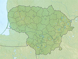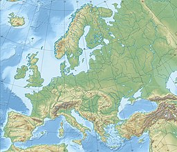
Kaliningrad Oblast is the westernmost federal subject of the Russian Federation, in Central and Eastern Europe. It is a semi-exclave situated on the Baltic Sea. The oblast is surrounded by two European Union and NATO members: Poland to the south and Lithuania to the north and east. The largest city and administrative centre of the province (oblast) is the city of Kaliningrad, formerly known as Königsberg. Half of the population of the oblast lives in Kaliningrad City proper. The port city of Baltiysk is Russia's only port on the Baltic Sea that remains ice-free in winter. Kaliningrad Oblast had a population of roughly 1 million in the Russian Census of 2021. The area of Kaliningrad oblast is 15,125 square kilometers.

Sambia or Samland or Kaliningrad Peninsula is a peninsula in the Kaliningrad Oblast of Russia, on the southeastern shore of the Baltic Sea. The peninsula is bounded by the Curonian Lagoon to the north-east, the Vistula Lagoon in the southwest, the Pregolya River in the south, and the Deyma River in the east. As Sambia is surrounded on all sides by water, it is technically an island. Historically it formed an important part of the historic region of Prussia.

East Prussia was a province of the Kingdom of Prussia from 1772 to 1829 and again from 1878 ; following World War I it formed part of the Weimar Republic's Free State of Prussia, until 1945. Its capital city was Königsberg. East Prussia was the main part of the region of Prussia along the southeastern Baltic Coast.

Klaipėda, historically also Memel, is a city in Lithuania on the Baltic Sea coast. It is the third largest city in Lithuania, the fifth largest city in the Baltic States and the capital of Klaipėda County, as well as the only major seaport in the country.

The Neman,Niemen or Nẽmunas is a river in Europe that rises in central Belarus and flows through Lithuania then forms the northern border of Kaliningrad Oblast, Russia's western exclave, which specifically follows its southern channel. It drains into the Curonian Lagoon, narrowly connected to the Baltic Sea. The 937 km (582 mi) long Neman is a major Eastern European river. It flows generally west to Grodno within 12 kilometres (7.5 mi) of the Polish border, north to Kaunas, then westward again to the sea.

Neringa or Neringa Municipality is a municipality of Klaipėda County in westernmost Lithuania, comprising several villages in the Curonian Spit. In terms of population, it is the smallest municipality of the country. Nida is the seat of government and largest town in Neringa Municipality.
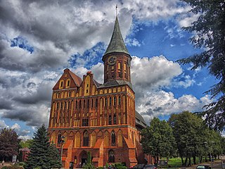
Prussia is a historical region in Central Europe on the south-eastern coast of the Baltic Sea, that ranges from the Vistula delta in the west to the end of the Curonian Spit in the east and extends inland as far as Masuria, divided between Poland, Russia and Lithuania. This region is often also referred to as Old Prussia.
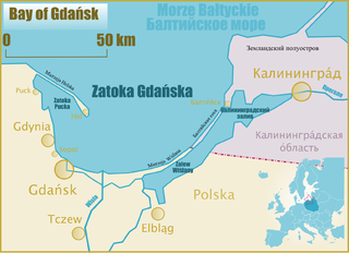
Gdańsk Bay or the Gulf of Gdańsk is a southeastern bay of the Baltic Sea. It is named after the adjacent port city of Gdańsk in Poland.

The Curonian (Courish) Spit is a 98-kilometre (61 mi) long, thin, curved sand-dune spit that separates the Curonian Lagoon from the Baltic Sea. It is a UNESCO World Heritage Site shared by Lithuania and Russia. Its southern portion lies within Kaliningrad Oblast of Russia, and its northern within southwestern Klaipėda County of Lithuania.

The Vistula Spit is an aeolian sand spit, or peninsular stretch of land, separating Vistula Lagoon from Gdańsk Bay, in the Baltic Sea, with its tip separated from the mainland by the Strait of Baltiysk. The border between Poland and Kaliningrad Oblast, an exclave of Russia, bisects it, politically dividing the spit into two pieces between the two countries. The westernmost geographical point of Russia is located on the Vistula Spit. The Polish part contains a number of tourist resorts, incorporated administratively as the town of Krynica Morska.

Klaipėda County is one of ten counties in Lithuania, bordering Tauragė County to the southeast, Telšiai County to the northeast, Kurzeme in Latvia to the north, and Kaliningrad Oblast in Russia to the south. To the west is the Baltic Sea. It lies in the west of the country and is the only county to have a coastline and not be landlocked. Its capital is Klaipėda. On 1 July 2010, the county administration was abolished, and since that date, Klaipėda County remains as the territorial and statistical unit.

Old Prussians, Baltic Prussians or simply Prussians were a Baltic people that inhabited the region of Prussia, on the southeastern shore of the Baltic Sea between the Vistula Lagoon to the west and the Curonian Lagoon to the east. As Balts, they spoke an Indo-European language of the Baltic branch now known as Old Prussian and worshipped pre-Christian deities. Their ethnonym was later adopted by predominantly Low German-speaking inhabitants of the region.
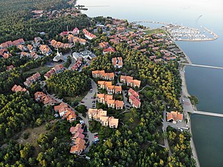
Nida is a resort town in Lithuania, the administrative centre of Neringa municipality. Located on the Curonian Spit between the Curonian Lagoon and the Baltic Sea, it is the westernmost point of Lithuania and the Baltic states, close to the border with the Russian Kaliningrad Oblast exclave. It currently has about 2,385 residents.

Lithuania Minor or Prussian Lithuania is a historical ethnographic region of Prussia, where Prussian Lithuanians lived, now located in Lithuania and the Kaliningrad Oblast of Russia. Lithuania Minor encompassed the northeastern part of the region and got its name from the territory's substantial Lithuanian-speaking population. Prior to the invasion of the Teutonic Knights in the 13th century, the main part of the territory later known as Lithuania Minor was inhabited by the tribes of Skalvians and Nadruvians. The land depopulated during the incessant war between Lithuania and the Teutonic Order. The war ended with the Treaty of Melno and the land was repopulated by Lithuanian newcomers, returning refugees, and the remaining indigenous Baltic peoples; the term Lithuania Minor appeared for the first time between 1517 and 1526.
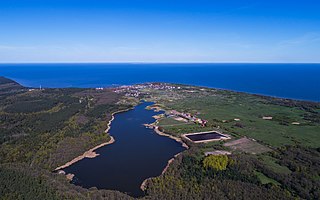
Rybachy is a rural settlement in Zelenogradsky District of Kaliningrad Oblast, Russia, located on the Curonian Spit. As of 2010 it has about 839 residents. It was formerly known for the Rossitten Bird Observatory and the Rossitten gliding school.

Natangians or Notangians was a Prussian clan, which lived in the region of Natangia, an area that is now mostly part of the Russian exclave Kaliningrad Oblast, whereas the southern portion lies in the Polish Warmian-Masurian Voivodeship.
Scalovia or Skalvia was the area of Prussia originally inhabited by the now extinct Baltic tribe of Skalvians or Scalovians which according to the Chronicon terrae Prussiae of Peter of Dusburg lived to the south of the Curonians, by the lower Nemunas river, in the times around 1240.
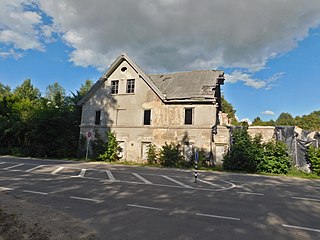
Nemirseta is a district of the Lithuanian seaside resort Palanga, located on the Baltic coast north of Klaipėda. The place, which consists mainly of two deserted buildings which were formerly an inn and customs house, is notable for having marked for about five centuries the northernmost point of Prussia and the northeastern tip of the German Empire from 1871 to 1920.

The Vistula Lagoon is a brackish water lagoon on the Baltic Sea roughly 56 miles (90 km) long, 6 to 15 miles wide, and up to 17 feet (5 m) deep, separated from the Gdańsk Bay by the Vistula Spit.

Curonian Spit National Park covers the Russian-owned southern 41 km of the 98 km long, curved Curonian Spit – a type of depositional sandbar. The spit separates the salt-water Baltic Sea from the freshwater Curonian Lagoon to the east. The southern portion of the spit lies within Zelenogradsky District in Kaliningrad Oblast, Russia; the northern portion lies within southwestern Lithuania. It is a UNESCO World Heritage Site shared by the two countries.

