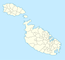
Malta, officially the Republic of Malta, is an island country in Southern Europe, located in the Mediterranean Sea. It consists of an archipelago between Italy, Tunisia and Libya. It lies 80 km (50 mi) south of Sicily and Italy, 284 km (176 mi) east of Tunisia, and 333 km (207 mi) north of Libya. The two official languages are Maltese, the only Semitic language with official status in a European country and the European Union, and English. The country's capital is Valletta.

The geography of Malta is dominated by water. Malta is an archipelago of coralline limestone, located in Europe, in the Mediterranean Sea, 81 kilometres south of Sicily, Italy, and nearly 300 km north (Libya) and northeast (Tunisia) of Africa. Although Malta is situated in Southern Europe, it is located farther south than Tunis, capital of Tunisia, Algiers, capital of Algeria, Tangier in Morocco and also Aleppo in Syria, and Mosul in Iraq in the Middle East. Only the three largest islands – Malta, Gozo and Comino – are inhabited. Other (uninhabited) islands are: Cominotto, Filfla and the St.Paul's Islands. The country is approximately 316 km2 (122 sq mi) in area. Numerous bays along the indented coastline of the islands provide harbours. The landscape of the islands is characterised by high hills with terraced fields. The highest point, at 253 metres, Ta' Zuta on mainland Malta. The capital is Valletta.
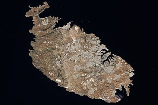
Malta is an island in Southern Europe. It is the largest and most populous of the three major islands that constitute the Maltese Archipelago.The island is situated in the Mediterranean Sea directly south of Italy and north of Libya. It lies south-east of the smaller islands of Gozo and Comino.The island is 27 kilometres (17 mi) long and 14.5 kilometres (9 mi) wide, with a total area of 246 square kilometres (95 sq mi). The capital is Valletta, while the largest locality is Rabat. The island is made up of many small towns, which together form one larger urban zone with a population of 409,259. The landscape is characterised by low hills with terraced fields.
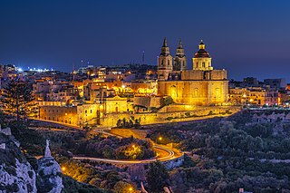
Mellieħa is a large village in the Northern Region of Malta. It has a population of 10,087 as of March 2014. Mellieħa is also a tourist resort, popular for its sandy beaches, natural environment, and Popeye Village nearby.

Comino is a small island of the Maltese archipelago between the islands of Malta and Gozo in the Mediterranean Sea, measuring 3.5 square kilometres (1.4 sq mi) in area. Named after the cumin seed, the island has a permanent population of only two residents and is part of the municipality of Għajnsielem, in southeastern Gozo, from where one priest and one policeman commute. The island is a bird sanctuary and nature reserve.

Birkirkara is a city in the eastern region of Malta. It is the second most populous on the island, with 24,356 inhabitants as of 2020. The town consists of five autonomous parishes: Saint Helen, Saint Joseph the Worker, Our Lady of Mount Carmel, Saint Mary and San Gorg Preca. The city's motto is In hoc signo vinces, and its coat of arms is a plain red cross, surmounted by a crown.

Għajnsielem, meaning "Peaceful Spring", is a municipality on the southeastern coast of the island of Gozo in Malta, including the entire island of Comino. It has a population of 3,200 residents, and is the first Gozitan village that greets the visitor on leaving Mġarr Harbour towards the Gozitan heartland. Its name originated from the water spring, around which in 1700, Grandmaster Perellos built an arcade containing public wash basins and fresh water spouts. Attractions include Lourdes Chapel with its sharp steeple and underlying niche of Our Lady of Lourdes, Fort Chambray and the towering of Ghajnsielem Parish Church.
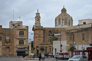
Nadur is an administrative unit of Malta, located in the eastern part of the island of Gozo. Nadur is built on a plateau and is one of the largest localities in Gozo. Known as the 'second city', it spreads along a high ridge to the east of Victoria. It had a population of 4,509 as of March 2014.

Qala is an administrative unit of Malta, on the island of Gozo, with a population of 1,929 as of September 2019. Nearby is Ħondoq ir-Rummien, a coastline with salt pans and caves.
The Ringgold Isles are an archipelago in Fiji, forming an outlier group to Vanua Levu. The Budd, Nukusemanu, and Heemskercq Reefs form part of the group. The group is mostly uninhabited, but Qelelevu has a small village. In 2008 Pacific rats were eradicated from seven islands of the group in an endeavour facilitated by BirdLife International's Fiji Programme.

Malta is for non-local government purposes divided into districts as opposed to the local government localities. The three main types of such districts – statistical, electoral at national level, and policing – have no mainstream administrative effect as the local councils form the first-tier – moreover only administrative tier – divisions of the country.

Armier Bay, is situated in the locality of Mellieħa, Malta. Armier Bay consists of two beaches, the biggest beach is known as Armier and the other one as Little Armier. The sea of this bay is crystal blue, like the water of the Blue Lagoon. This is because it is situated exactly in the opposite direction of Comino, like Ħondoq ir-Rummien in Gozo, and so this makes it the most crystal blue sea on the island of Malta.
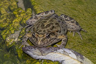
Discoglossus pictus, the Mediterranean painted frog or simply painted frog, is a species of frog in the family Alytidae.

Gozo Region is one of five regions of Malta. The region includes the islands of Gozo, Comino and several little islets such as Cominotto. The region does not border any other regions, but it is close to the Northern Region.

Ħalfa Rock(Maltese: Il-Ġebla tal-Ħalfaor Il-Blata tal-Ħalfa) is a deserted small islet and limestone rock on the south-east coast of the island of Gozo in the Maltese archipelago. The small islet is typified by a small maritime labiate garrigue environment, with germander and prasium shrubs, with the occurrence of the endemic Maltese Pyramidal Orchid as well as endemic coastal communities based on the Maltese Sea-Lavender and the sub-endemic Maltese Crosswort.

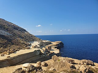
The Geology of Malta consists of a sequence of sedimentary rocks of late Oligocene to late Miocene age cut through by a set of extensional faults of Pliocene age.

The geographyof Gozo, is dominated by water as it is the second largest island in the Maltese archipelago and is made up out of limestone. There are several islands which fall under Gozitan jurisdiction and thus are additions to the overarching Maltese archipelago. The main island of Gozo is located 7 kilometres (4.3 mi) northwest of the main island of Malta. It is mostly known for its multitude of low-lying hills. The highest point in Gozo is Ta' Dbiegi hill, which falls under the San Lawrenz local council. The island of Comino, which is also the third largest island in Malta, falls under Gozo.
Il-Blata tal-Melħ is a landmark in the north-western region of the island of Malta, close to Rabat and Mġarr. The name Il-Blata tal-Melħ can be translated as the Salt Rock, named after a series of salt deposits in the limestone at this location.