
The Alps are the highest and most extensive mountain range system that lies entirely in Europe, stretching approximately 1,200 km (750 mi) across seven Alpine countries : France, Switzerland, Italy, Liechtenstein, Austria, Germany, and Slovenia.

Liechtenstein, officially the Principality of Liechtenstein, is a German-speaking microstate located in the Alps between Austria and Switzerland. Liechtenstein is a semi-constitutional monarchy headed by the Prince of Liechtenstein.

Austria is a predominantly mountainous country in Central Europe, approximately between Germany, Italy and Hungary. It has a total area of 83,871 square kilometres (32,383 sq mi), about 2.031706 times the size of Switzerland.

The valleys of the Alps have been inhabited since prehistoric times. The Alpine culture, which developed there, centers on transhumance.

Vorarlberg is the westernmost state of Austria. It has the second-smallest geographical area after Vienna and, although it also has the second-smallest population, it is the state with the second-highest population density. It borders three countries: Germany, Switzerland, and Liechtenstein. The only Austrian state that shares a border with Vorarlberg is Tyrol, to the east.

The Bregenz Forest is one of the main regions in the state of Vorarlberg (Austria). It overlaps, but is not coterminous with, the Bregenz Forest Mountains, which belong to a range of the Northern Limestone Alps, specifically the northern flysch zone. It is the drainage basin of the Bregenzer Ach river.

The Alpine Rhine Valley is a glacial alpine valley, formed by the part of the Alpine Rhine between the confluence of the Anterior Rhine and Posterior Rhine at Reichenau and the Alpine Rhine's mouth at Lake Constance. It covers three countries and the full length of the Alpine Rhine is 93.5 km.

The Rätikon is a mountain range of the Central Eastern Alps, located at the border between Vorarlberg, Liechtenstein and Graubünden. It is the geological border between the Eastern and Western Alps and stretches from the Montafon as far as the Rhine. In the south, the Prättigau is its limit, and in the north, it is the Walgau. In the east, it borders the Silvretta groups. The Rätikon mountain range derives its name from Raetia, a province of the Roman Empire, named after the Rhaetian people.

Montafon is a 39 km long valley in the westernmost Austrian federal state of Vorarlberg.

Drei Schwestern is a mountain located on the border of Austria and Liechtenstein. It forms a natural boundary between Liechtenstein and the Austrian state of Vorarlberg.

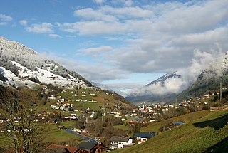
Schwarzenberg is a municipality in the Bregenz Forest in the western Austrian state of Vorarlberg, part of the district of Bregenz. Schwarzenberg has an area of 25.76 km². It lies south of Lake Constance. The village center is heritage-protected for its traditional rustic wooden houses.

Planken is a municipality in Oberland, Liechtenstein. It has four exclaves, two enclaves and a population of 473. Thus by population it is the smallest municipality of Liechtenstein.

Eastern Alps is the name given to the eastern half of the Alps, usually defined as the area east of a line from Lake Constance and the Alpine Rhine valley up to the Splügen Pass at the Alpine divide and down the Liro River to Lake Como in the south. The peaks and mountain passes are lower than the Western Alps, while the range itself is broader and less arched.

Alpine transhumance is transhumance as practiced in the Alps, that is, a seasonal droving of grazing livestock between the valleys in winter and the high mountain pastures in summer. Transhumance is a traditional practice that has shaped much of the landscape in the Alps, as without it, most areas below 2,000 m (6,600 ft) would be forests. While tourism and industry contribute today much to Alpine economy, seasonal migration to high pastures is still practiced in Bavaria, Austria, Slovenia, Italy, France and Switzerland, except in their most frequented tourist centers. In some places, cattle are taken care of by local farmer families who move to higher places. In others, this job is for herdsmen who are employees of the cooperative owning the pastures.
Gemeinde Gaschurn-Partenen is a municipality in the district of Bludenz in the westernmost Austrian state of Vorarlberg. The two largest villages are Gaschurn Dorf and Partenen.

The Lechquellen Mountains or Lechquellen range is a small mountain group within the Northern Limestone Alps of the Eastern Alps. It lies entirely within the Austrian state of Vorarlberg and includes the upper reaches of the river Lech with its headstreams in a horseshoe shape as well as the Upper Großwalsertal valley.

The Großes Walsertal is a valley located in the Austrian state of Vorarlberg. It is a side valley of the Walgau and stretches from there north to the mountainous center of the country. The end of the valley borders on the Bregenz Forest.

The Brandnertal is a valley in the Austrian province of Vorarlberg as well as a ski resort named after the valley.

The KäseStrasse Bregenzerwald is a non-profit organisation and route which links cheese-producing businesses of the Bregenz Forest in Vorarlberg (Austria).

Vorarlberger Bergkäse is a regional cheese specialty from the Austrian state of Vorarlberg. It is protected within the framework of the European designation of origin (PDO).
